Gjøvik is a municipality in Innlandet county, Norway. It is located in the traditional district of Toten. The administrative centre of the municipality is the town of Gjøvik. Some of the villages in Gjøvik include Biri, Bybrua, and Hunndalen.

is a municipality in Innlandet county, Norway. It is located in the traditional district of Gudbrandsdal. The administrative centre of the municipality is the village of Vålebru.

Østre Toten is a municipality in Innlandet county, Norway. It is located in the traditional district of Toten. The administrative centre of the municipality is the village of Lena. Other villages in the municipality include Kapp, Kolbu, Kraby, Lensbygda, Nordlia, Skreia, and Sletta.

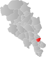
Vestre Toten is a municipality in Innlandet county, Norway. It is located in the traditional district of Toten. The administrative centre of the municipality is the village of Raufoss. Other villages in the municipality include Bøverbru, Eina, and Reinsvoll.

is a municipality in Innlandet county, Norway. It is located in the traditional district of Hadeland. The administrative centre of the municipality is the village of Jaren. Other villages in Gran include Bjoneroa, Brandbu, Egge, Gran, and Ringstad.

Søndre Land is a municipality in Innlandet county, Norway. It is located in the traditional district of Land. The administrative centre of the municipality is the village of Hov. Other villages in the municipality include Fluberg and Odnes.

Nordre Land is a municipality in Innlandet county, Norway. It is located in the traditional district of Land. The administrative centre of the municipality is the village of Dokka. Other villages in the municipality include Vest-Torpa, Nord-Torpa, Aust-Torpa, Fagerlund, and Nordsinni.

Etnedal is a municipality in Innlandet county, Norway. It is located in the traditional district of Valdres. The administrative centre of the municipality is the village of Bruflat.

Vestre Slidre is a municipality in Innlandet county, Norway. It is located in the traditional district of Valdres. The administrative centre of the municipality is the village of Slidre. Other villages in Vestre Slidre include Lomen and Røn.

Øystre Slidre is a municipality in Innlandet county, Norway. It is located in the traditional district of Valdres. The administrative centre of the municipality is the village of Heggenes. Other villages in the municipality include Hegge, Rogne, Volbu, Moane, Skammestein, Beito, and Beitostølen.

Østre Gausdal is a former municipality in the old Oppland county, Norway. The 227-square-kilometre (88 sq mi) municipality existed from 1879 until its dissolution in 1962. The area is now part of Gausdal Municipality. The administrative centre was the village of Segalstad bru.

Vestre Gausdal is a former municipality in the old Oppland county, Norway. The 959-square-kilometre (370 sq mi) municipality existed from 1879 until its dissolution in 1962. The area is now part of Gausdal Municipality. The administrative centre was the village of Forset.
Snertingdal is a former municipality in the old Oppland county, Norway. The 220-square-kilometre (85 sq mi) municipality existed from 1910 until its dissolution in 1964. The area is now part of Gjøvik Municipality in the traditional district of Vestoppland. The administrative centre was the village of Seegård.
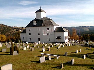
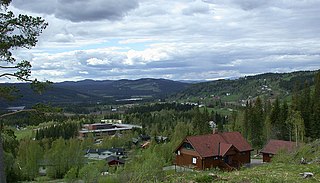
Torpa is a former municipality in the old Oppland county, Norway. The 561-square-kilometre (217 sq mi) municipality existed from 1914 until its dissolution in 1962. The area is now part of Nordre Land Municipality. The administrative centre was the village at Åmot where the Åmot Church is located. Torpa currently constitutes the northern part of the Nordre Land, bordering the municipalities of Etnedal and Nord-Aurdal in the west, Gausdal, Lillehammer, and Gjøvik in the east.

Heidal is a former municipality in the old Oppland county, Norway. The 349-square-kilometre (135 sq mi) municipality existed from 1908 until its dissolution in 1965. The former municipality is now part of the present-day Sel Municipality in Innlandet county. The administrative centre of the old municipality was the village of Bjølstad where the Heidal Church is located. The municipality encompassed the whole Heidal valley area.

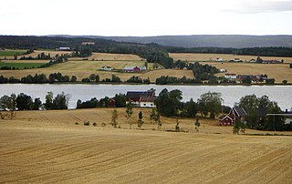
Fluberg is a former municipality in the old Oppland county, Norway. The municipality existed from 1914 until its dissolution in 1962. The area is now divided between Nordre Land Municipality and Søndre Land Municipality. It encompassed both sides of the northern part of the large lake Randsfjorden. The administrative centre was the village of Fluberg.

Brandbu is a former municipality in the old Oppland county, Norway. The 471-square-kilometre (182 sq mi) municipality existed from 1897 until its dissolution in 1962. The area is now part of Gran Municipality in the traditional district of Hadeland. The administrative centre was the village of Brandbu. The municipality included land on both sides of the large lake Randsfjorden, although most of the municipal residents lived on the east side of the lake.

Kolbu is a former municipality in the old Oppland county, Norway. The 132-square-kilometre (51 sq mi) municipality existed from 1908 until its dissolution in 1964. The area is now part of Østre Toten Municipality in the traditional district of Toten. The administrative centre was the village of Kolbu.
Eina is a former municipality in the old Oppland county, Norway. The 104-square-kilometre (40 sq mi) municipality existed from 1908 until its dissolution in 1964. The area is now part of Vestre Toten Municipality in the traditional district of Toten. The administrative centre was the village of Eina.

Biri is a former municipality in the old Oppland county, Norway. The 188-square-kilometre (73 sq mi) municipality existed from 1838 until its dissolution in 1964. The area is now part of Gjøvik Municipality in the traditional district of Vestoppland. The administrative centre was the village of Biri.