
Gjøvik is a municipality in Innlandet county, Norway. It is located in the traditional district of Toten. The administrative centre of the municipality is the town of Gjøvik. Some of the villages in Gjøvik include Biri, Bybrua, and Hunndalen.

Sør-Fron is a municipality in Innlandet county, Norway. It is located in the traditional district of Gudbrandsdal. The administrative centre of the municipality is the village of Hundorp. Other villages in the municipality include Gålå, Harpefoss, and Lia.

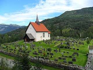
is a municipality in Innlandet county, Norway. It is located in the traditional district of Gudbrandsdal. The administrative centre of the municipality is the village of Vålebru.

Gausdal is a municipality in Innlandet county, Norway. It is located in the traditional district of Gudbrandsdal. The administrative centre of the municipality is the village of Follebu. Other villages in Gausdal include Segelstad, Forset, and Svingvoll.

Østre Toten is a municipality in Innlandet county, Norway. It is located in the traditional district of Toten. The administrative centre of the municipality is the village of Lena. Other villages in the municipality include Kapp, Kolbu, Kraby, Lensbygda, Nordlia, Skreia, and Sletta.

Vestre Toten is a municipality in Innlandet county, Norway. It is located in the traditional district of Toten. The administrative centre of the municipality is the village of Raufoss. Other villages in the municipality include Bøverbru, Eina, and Reinsvoll.

is a municipality in Innlandet county, Norway. It is located in the traditional district of Hadeland. The administrative centre of the municipality is the village of Jaren. Other villages in Gran include Bjoneroa, Brandbu, Egge, Gran, and Ringstad.

Søndre Land is a municipality in Innlandet county, Norway. It is located in the traditional district of Land. The administrative centre of the municipality is the village of Hov. Other villages in the municipality include Fluberg and Odnes.

Nordre Land is a municipality in Innlandet county, Norway. It is located in the traditional district of Land. The administrative centre of the municipality is the village of Dokka. Other villages in the municipality include Vest-Torpa, Nord-Torpa, Aust-Torpa, Fagerlund, and Nordsinni.

Sør-Aurdal is a municipality in Innlandet county, Norway. It is located in the traditional district of Valdres. The administrative centre of the municipality is the village of Bagn. Other villages in the municipality include Begna, Hedalen, and Begnadalen.

Etnedal is a municipality in Innlandet county, Norway. It is located in the traditional district of Valdres. The administrative centre of the municipality is the village of Bruflat.

Nord-Aurdal is a municipality in Innlandet county, Norway. It is located in the traditional district of Valdres. The administrative centre of the municipality is the town Fagernes. Other urban centres in Nord-Aurdal include the villages of Aurdal, Leira, and Skrautvål. The municipality is served by Fagernes Airport, Leirin. In Nord-Aurdal, there is an alpine skiing center called Valdres Alpinsenter.

Vestre Slidre is a municipality in Innlandet county, Norway. It is located in the traditional district of Valdres. The administrative centre of the municipality is the village of Slidre. Other villages in Vestre Slidre include Lomen and Røn.

Øystre Slidre is a municipality in Innlandet county, Norway. It is located in the traditional district of Valdres. The administrative centre of the municipality is the village of Heggenes. Other villages in the municipality include Hegge, Rogne, Volbu, Moane, Skammestein, Beito, and Beitostølen.

Vang is a municipality in Innlandet county, Norway. It is located in the traditional district of Valdres. The administrative centre of the municipality is the village of Vang i Valdres. Other villages in Vang include Hænsgardane, Nystuen, Øye, Ryfoss, and Tyinkrysset.

Hjartdal is a municipality in Telemark county, Norway. It is located in the traditional district of Upper Telemark and Aust-Telemark. The administrative centre of the municipality is the village of Sauland. Other villages in the municipality include Tuddal and Hjartdalsbygda.

Kviteseid is a municipality in Telemark county, Norway. It is located in the traditional districts of Vest-Telemark and Upper Telemark. The administrative centre of the municipality is the village of Kviteseidbyen. Other villages in Kviteseid include Åsgrend, Brunkeberg, Eidstod, Fjågesund, Kilen, Morgedal, and Vrådal.
Seljord is a municipality in Telemark county, Norway. It is located in the traditional districts of Upper Telemark and Vest-Telemark. The administrative centre of the municipality is the village of Seljord. Other villages in the municipality include Flatdal and Åmotsdal.
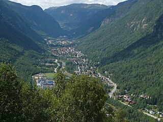
Tinn is a municipality in Telemark county, Norway. It is located in the traditional districts of Aust-Telemark and Upper Telemark. The administrative centre of the municipality is the town of Rjukan. Some of the villages in Tinn include Atrå, Austbygde, Hovin, and Miland.

Hof is a former municipality in Vestfold county, Norway. The 163-square-kilometre (63 sq mi) municipality existed from 1838 until its dissolution in 2018. The area is now part of Holmestrand Municipality in the traditional district of Jarlsberg. The administrative centre was the village of Hof. Other villages in the municipality included Eidsfoss and Sundbyfoss.


