Thurgau, anglicized as Thurgovia, more formally the Canton of Thurgau, is one of the 26 cantons forming the Swiss Confederation. It is composed of five districts and its capital is Frauenfeld.
Bremgarten District is a Swiss district in the Canton of Aargau, corresponding to the valleys of the Reuss and Bünz rivers in the area known as the Freiamt.
Zofingen District is a district in the Swiss canton of Aargau. It is located in the southwest corner of the Canton. The seat is Zofingen. The largest municipality in population is Oftringen, the smallest is Wiliberg. It has a population of 73,843.
Muri District is a district in the Swiss Canton of Aargau with the administrative capital of Muri. It covers the central and southern part of Freiamt and has a population of 37,379.

Moesa District, often referred to as Moesano, is a former administrative district in the canton of Graubünden, Switzerland. It had an area of 473.74 km2 (182.91 sq mi) corresponding to the Val Mesolcina, the valley of the eponymous Moesa River. It was replaced with the Moesa Region on 1 January 2017 as part of a reorganization of the Canton.
Nyon District is a district in the canton of Vaud, Switzerland. The seat of the district is the city of Nyon.
Horgen District is a district of Canton of Zürich in Switzerland. The district is located in the Zimmerberg and Sihl Valley region on the left shore of Lake Zürich; its district capital is Horgen. In the northern part of the district, the municipalities have grown together with the city of Zürich, while in the south-western part, the Sihlwald is the largest contiguous natural mixed deciduous forest on the Swiss Plateau. The district consists of 11 municipalities and has a population of 127,263 and an area of 104.16 km2 (40.22 sq mi).
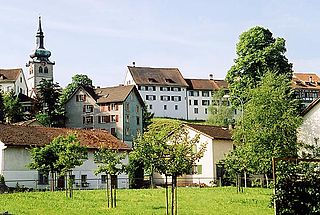
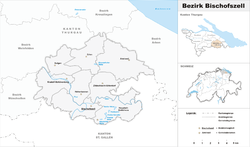
Bischofszell is a village and a municipality in Weinfelden District in the canton of Thurgau in Switzerland. It is the seat of the district. In 1987, the city was awarded the Wakker Prize for the preservation of its architectural heritage. So was its neighboring city Hauptwil-Gottshaus in 1999.
Hauptwil-Gottshaus is a municipality in Weinfelden District in the canton of Thurgau in Switzerland.
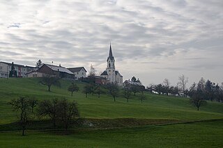
Hohentannen is a municipality in Weinfelden District in the canton of Thurgau in Switzerland.
Münchwilen District is one of the five districts of the canton of Thurgau, Switzerland. It has a population of 48,285. Its capital is the town of Münchwilen.
Arbon District is one of the five districts of the canton of Thurgau in Switzerland. It has a population of 58,414. Its capital is the town of Arbon.
Frauenfeld District is one of the five districts of the canton of Thurgau, Switzerland. It has a population of 69,773. Its capital, and the capital of Thurgau, is the city of Frauenfeld. The district shares borders with canton Zurich and canton Schaffhausen as well a river border with the German enclave of Büsingen am Hochrhein.
Kreuzlingen District is one of the five districts of the canton of Thurgau in Switzerland. It has a population of 49,760. Its capital is the city of Kreuzlingen.
Weinfelden District is one of the five districts of the canton of Thurgau, Switzerland. It has a population of 56,677. Its capital is the town of Weinfelden.
Winterthur District is one of the twelve districts of the German-speaking canton of Zürich, Switzerland. It has a population of 173,053. Its capital is the city of Winterthur.
The district of Monthey is a district of the canton of Valais in Switzerland. It has a population of 47,912.
The district of Saint-Maurice is a district in the canton of Valais in Switzerland. It has a population of 14,102.

Biel/Bienne District is an administrative district in the Canton of Bern, Switzerland. It is located along both shores of the northeastern half of Lake Biel and is part of the Seeland administrative region, and its capital is Biel/Bienne. It contains 19 municipalities with an area of 97.63 km2 (37.70 sq mi) and a population of 90,536, over half of which lives in the district's capital. While it is the smallest district in surface area, it has the third largest population in the canton.
The Moesa Region is one of the eleven administrative districts in the Canton of the Grisons in Switzerland. It had an area of 473.74 square kilometers (182.91 sq mi) and a population of 8,770 .. It was created on 1 January 2017 as part of a reorganization of the Canton.