
The Blackdown Hills, or Blackdowns, are a range of hills along the Somerset-Devon border in south-western England. The plateau is dominated by hard chert bands of Upper Greensand with some remnants of chalk, and is cut through by river valleys.
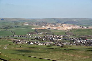
Dove Holes is a village in the High Peak district of Derbyshire, England. It has a population of about 1,200 (2001), shown in the 2011 Census as being included in the population of Chapel-en-le-Frith. It straddles the A6 road, approximately three miles north of Buxton and three miles south of Chapel-en-le-Frith.

The Minera Limeworks were extensive lime quarries and kilns at Minera in Wrexham, Wales. It was located at grid reference SJ253520, near the villages of Gwynfryn, Minera, and Coedpoeth and was locally referred to as The Calch.
Browne's Folly, or Brown's Folly, is a folly tower sitting within a 39.9 hectare biological and geological Site of Special Scientific Interest (SSSI) near the English village of Bathford in Somerset, notified in 1974: the site itself is known as the Farleigh Down Stone Quarry and is managed as a nature reserve by the Avon Wildlife Trust (AWT). The tower was built in 1848 and is a Grade II listed building.

The Cheddar Complex is a 441.3-hectare (1,090-acre) biological Site of Special Scientific Interest near Cheddar around the Cheddar Gorge and north east to Charterhouse in the Mendip Hills, Somerset, England, notified in 1952.
The Griggsville Landing Lime Kiln is located near the village of Valley City, Illinois in Pike County. The periodic lime kiln is listed on the National Register of Historic Places, a designation it gained in August 1999. It is actually within the boundaries of the Ray Norbut State Fish and Wildlife Area. The kiln represents an example of an 1850s lime kiln, one of the best-preserved examples of such a kiln. In its heyday the kiln's raw product would have been quicklime. The kiln is one of twelve Pike County sites included in the National Register of Historic Places. Some other examples are the Lyman Scott House, in Summer Hill and the New Philadelphia Town Site, somewhere near Barry, Illinois.

Batts Combe quarry, grid reference ST460550 is a limestone quarry on the edge of Cheddar village on the Mendip Hills, Somerset, England.

Penwyllt is a hamlet located in the upper Swansea Valley in Powys, Wales, lying within the Brecon Beacons National Park.
There are several nature reserves in the surroundings of Nailsea, North Somerset, England, which is located at 51°25′55″N2°45′49″W.

Wotton Hill is a hill on the edge of the Cotswold Hills in Gloucestershire, England, 0.5 miles (0.80 km) north of Wotton-under-Edge. The Cotswold Way passes over the hill.

Hobbs Quarry, Longhope is a 1-hectare (2.5-acre) geological and biological Site of Special Scientific Interest in Gloucestershire, England, notified in 1966. It is situated midway between Longhope and Dursley Cross in the Forest of Dean. Adjacent woods are Kiln Wood and Coleman's Wood. The site was managed by the Gloucestershire Wildlife Trust. Ownership changed to an independent Charitable Trust - Hobbs Nature Reserve Trust - on 1 August 2023. The Management Plan is similar to the one GWT had agreed with Natural England, combining conservation and research work on the geological exposures and preservation of the valuable natural environment. An explanatory website is under development to aid any groups planning educational visits. Local specialists are available to assist with these if required.
Swift's Hill is a 9.15-hectare (22.6-acre) biological and geological Site of Special Scientific Interest in Gloucestershire, notified in 1966 and renotified in 1984.

Harpur Hill Quarry is a disused limestone quarry on Harpur Hill, Derbyshire, England. Limestone was extracted there from 1835 to 1952 for lime burning at lime kilns to produce quicklime. The quarry was used by the Royal Air Force as a chemical weapons storage depot during the Second World War, the largest such depot in the United Kingdom. Afterwards a number of captured German chemical munitions were disposed of at the site by burning, which was only partially successful. The RAF depot closed in 1960 and the site is now vacant.
Ridley Bottom is a 1.1-hectare (2.7-acre) nature reserve in Gloucestershire. The site is listed in the 'Forest of Dean Local Plan Review' as a Key Wildlife Site (KWS).

The Milwaukee Falls Lime Company is the former owner of a limestone quarry and lime kilns located in Grafton, Wisconsin. It was added to the National Register of Historic Places in 2012. The quarry and kilns are now Lime Kiln Park, which also features a pavilion, playground, walking paths, sledding hill, horseshoe pits, and disc golf course.

Betchworth Quarry and Lime Kilns is a 27-hectare (67-acre) nature reserve north of Betchworth in Surrey. Betchworth Quarry only is managed by Surrey Wildlife Trust. It is part of the Mole Gap to Reigate Escarpment Site of Special Scientific Interest and Special Area of Conservation.

Howell Hill is a 5-hectare (12-acre) nature reserve east of Ewell in Surrey. It is owned by Surrey County Council and managed by the Surrey Wildlife Trust.

A limepit is either a place where limestone is quarried, or a man-made pit used to burn lime stones in the same way that modern-day kilns and furnaces constructed of brick are now used above ground for the calcination of limestone (calcium carbonate, CaCO3) and by which quicklime (calcium oxide, CaO) is produced, an essential component in waterproofing and in wall plastering (plaster skim).

Quarry Moor is a Site of Special Scientific Interest, or SSSI, at the south edge of Ripon, North Yorkshire, England, and adjacent to the A61 road. It contains an outcrop of Magnesian Limestone, exposed by former quarrying. 255 million years ago this limestone was the peripheral sediment of a tropical sea. The land was donated in 1945 to the people of Ripon by the town's mayor, Alderman Thomas Fowler Spence, a varnish manufacturer. The land was notified as an SSSI in 1986 because its calcareous grassland supported a large diversity of plant species. The site features a Schedule 8 protected plant, thistle broomrape. The land is protected as a nature reserve, and it is also managed as a recreational area. Therefore, its calcareous grass area is fenced off for protection and study, but it also contains a car park, information signs, a children's play area, accessible paths, benches, and dog waste bins.

The Buxton lime industry has been important for the development of the town of Buxton in Derbyshire, England, and it has shaped the landscape around the town.


