
Mount Diablo is a mountain of the Diablo Range, in Contra Costa County of the eastern San Francisco Bay Area in Northern California. It is south of Clayton and northeast of Danville. It is an isolated upthrust peak of 3,849 feet, visible from most of the San Francisco Bay Area. Mount Diablo appears from many angles to be a double pyramid and has many subsidiary peaks. The largest and closest is North Peak, the other half of the double pyramid, which is nearly as high in elevation at 3,557 feet (1,084 m), and is about one mile northeast of the main summit.

The Wenatchee Mountains are a range of mountains in central Washington State, United States of America. A major subrange of the Cascade Range, extending east 50 miles (80 km) from the Cascade crest, the Wenatchee Mountains separate the drainage basins of the Yakima River from the Wenatchee River. The crest of the range forms part of the boundary between Chelan and Kittitas Counties.
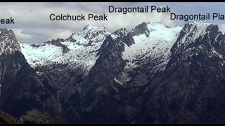
The Stuart Range is a mountain range in central Washington, United States. The range lies within the eastern extent of the Cascade Range immediately southwest of Leavenworth and runs east–west. The western peaks make up a single sharp ridge. The eastern half of the range splits into two parallel ridges, the northern of which is known as the Enchantment Peaks. Between these ridges lies the Enchantment Basin, which holds the dozens of tarns known as the Enchantment Lakes. Collectively, the basin and the encircling eastern peaks of the Stuart Range make up The Enchantments, a well-known backpacking destination. The south face of the Stuart Range falls off steeply to Ingalls Creek, beyond which rise the roughly parallel Wenatchee Mountains.

Black Mountain, also known as Mount Day, is a mountain in the Diablo Range of eastern Santa Clara County, California, east of Poverty Ridge and Arroyo Hondo, and about 10 miles (16 km) from Milpitas.

The Diablo Range is a mountain range in the California Coast Ranges subdivision of the Pacific Coast Ranges in northern California, United States. It stretches from the eastern San Francisco Bay area at its northern end to the Salinas Valley area at its southern end.
The Anticline Ridge is a ridge, southeast of Joaquin Ridge, declining from its 3,629 foot / 1,106 meter high point, Black Mountain in the north at 36°18′16″N120°24′12″W, to the southeast into low hills bound on the southeast by Los Gatos Creek that divides it from the Guijarral Hills. It is located in the inner California Coast Ranges, in Fresno County, California, east of the town of Coalinga. Anticline Ridge and Guijarral Hills divides Pleasant Valley from the San Joaquin Valley to the east. California State routes 33 and 198, which join together for the stretch through and north of Coalinga, cut across the Coalinga field and cross Anticline Ridge.
Oak Mountain is a mountain in the northern Peninsular Ranges System, in Riverside County, in southern California.
Mount Wallace is a summit in the Diablo Range, in Alameda County, California. Mount Wallace rises to and elevation of 3,091 feet.
Brushy Peak, also known as Brushy Knob or Las Cuevas, is a summit in Alameda County, California that overlooks the Livermore Valley. North of the valley, it is part of the Diablo Range. It rises to an elevation of 1,686 feet (514 m) and is the location of Brushy Peak Regional Preserve; there are guided tours to the peak itself.
Red Hill is a summit on the eastern slope of the Diablo Range, in Merced County, California. Its highest elevation is 2,326 feet. The summit is part of a long ridge where its high point is between 37°07′35″N121°11′31″W and 37°07′27″N121°11′50″W. The Red Mountain Road, runs over this ridge between Fifield Road on the divide of the Diablo Range and McCabe Road on Romero Creek.
Joaquin Ridge is a ridge in the Diablo Range in Fresno County, California. The ridge is named for Joaquin Murietta (1830-1853), a California Gold Rush bandit, leader of the Five Joaquins Gang, who used this region as a rendezvous and camp that overlooked the gangs base at the Rancho de Cantua. The ridge is ten miles long, running from its high point at 36°19′48″N120°34′09″W, east of Spanish Lake, eastward to Joaquin Rocks 36°19′11″N120°27′32″W, and then southwestward to 36°18′15″N120°24′11″W near 3,629-foot Black Mountain at 36°18′16″N120°24′12″W the high point on the south southeast trending Anticline Ridge. Joaquin Ridge is bound on the northeast by the Ragged Valley and the Big Blue Hills and on the southwest by Portuguese Canyon. Its highest elevation is 4,701 feet, 0.64 km (0.40 mi) east of Spanish Lake.
Mustang Peak is a summit in the Diablo Range on the northwest - southeast trending range of mountains marking the boundary of Monterey County and Fresno County, California. This summit rises to an elevation of 3,596 feet. It overlooks the Kreyenhagen Hills and Kettleman Plain beyond it to the east, and the Jacalitos Hills and Pleasant Valley beyond it to the north. To the south is Joaquin Canyon, tributary to Cholame Creek and to the west is Mine Mountain and Cholame Creek beyond it, below its summit.
