Gloucestershire is a county in South West England. The county comprises part of the Cotswold Hills, part of the flat fertile valley of the River Severn and the entire Forest of Dean.

Dymock is a village and civil parish in the Forest of Dean district of Gloucestershire, England, about four miles south of Ledbury. In 2014 the parish had an estimated population of 1,205.
Tadley is a town and civil parish in the English county of Hampshire.

The Forest of Dean is a geographical, historical and cultural region in the western part of the county of Gloucestershire, England. It forms a roughly triangular plateau bounded by the River Wye to the west and northwest, Herefordshire to the north, the River Severn to the south, and the City of Gloucester to the east.

Wickwar is a village and civil parish in Gloucestershire, England, located between Yate and Charfield. At the 2001 census, the parish had a population of 1,943.

Forest of Dean is a local government district in Gloucestershire, England, named after the Forest of Dean. Its council is based in Coleford. Other towns and villages in the district include Blakeney, Cinderford, Drybrook, English Bicknor, Huntley, Littledean, Longhope, Lydbrook, Lydney, Mitcheldean, Newnham and Newent.

Forest of Dean is a constituency in Gloucestershire represented in the House of Commons of the UK Parliament since 2005 by Mark Harper, a Conservative who has served as Secretary of State for Transport since 2022.

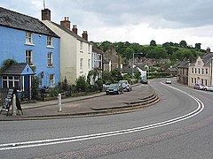
Tidenham is a village and civil parish in the Forest of Dean of west Gloucestershire, England, adjoining the Welsh border. Tidenham is bounded by the River Wye to the west and the River Severn to the south. Offa's Dyke runs through the western part of the parish, terminating at Sedbury cliff above the River Severn.
Alvington is a village and civil parish in the Forest of Dean in Gloucestershire, England, situated on the A48 road, six miles north-east of Chepstow in Wales. The parish had a total population of 506 at the 2011 census.
Arlingham is a village and civil parish in the Stroud District of Gloucestershire, England. The 2001 Census recorded a parish population of 410, increasing to 459 at the 2011 census. The parish contains the hamlets of Milton End, Overton and Priding. The next parish to the east is Fretherne with Saul.

Awre is a village, civil parish and electoral ward in the Forest of Dean District of Gloucestershire, England, near the River Severn.

Broadwell is a village and civil parish in the English county of Gloucestershire. It is about 1.5 miles (2.4 km) north of Stow-on-the-Wold, In the 2001 United Kingdom census, the parish had a population of 384. decreasing to 355 at the 2011 census.

Dumbleton is a village and civil parish in the English county of Gloucestershire. The village is roughly 20 miles from the city of Gloucester. The village is known to have existed in the time of Æthelred I who granted land to Abingdon Abbey, and it is mentioned in the Domesday Book.

Redmarley D'Abitot is a civil parish and village in the Forest of Dean district, Gloucestershire, South West England. In addition to the village of Redmarley, the civil parish also includes the settlements of Lowbands, Haw Cross, Playley Green, Kings Green and Durbridge. At the 2001 census the parish had a population of 705, increasing to 756 at the 2011 census.

Littledean is a village in the Forest of Dean, west Gloucestershire, England. The village has a long history and formerly had the status of a town. Littledean Hall was originally a Saxon hall, although it has been rebuilt and the current house dates back to 1612. The remains of a Roman temple are situated in the grounds. Neither the hall or Roman remains are open to the public.

Hartpury is a civil parish in Gloucestershire, England. It has an area of about 3,500 acres (1,400 ha), about 270 homes and a population of about 700 people, increasing to 1,642 at the 2011 census. The village is about 5 miles (8 km) north of Gloucester. Geographically the parish is in Leadon Vale; administratively it is in the Forest of Dean. The Hartpury University and Hartpury College campus is based in the village.

Woolaston is a village and civil parish in the Forest of Dean district of Gloucestershire in South West England. It lies on the north side of the Severn Estuary approximately 5 miles from the Welsh border at Chepstow and is surrounded by woodland and agricultural land.

Purton is a hamlet on the west bank of the River Severn, in the civil parish of Lydney in Gloucestershire, England. It lies opposite the village of Purton near Berkeley on the east bank of the river.
Awre for Blakeney railway station is a closed railway station in Gloucestershire, England, which served both the village of Awre and the town of Blakeney.

Bledisloe was an ancient hundred of Gloucestershire, England. It comprised the ancient parishes of