
In physical geography, tundra is a type of biome where the tree growth is hindered by frigid temperatures and short growing seasons. The term tundra comes through Russian тундра from the Kildin Sámi word тӯндар meaning "uplands", "treeless mountain tract". There are three regions and associated types of tundra: Arctic tundra, alpine tundra, and Antarctic tundra.
National nature reserves in England were established by English Nature, now Natural England, which manages them either directly or through non-governmental organisations such as the Royal Society for the Protection of Birds or the National Trust.

A bog or bogland is a wetland that accumulates peat as a deposit of dead plant materials – often mosses, typically sphagnum moss. It is one of the four main types of wetlands. Other names for bogs include mire, mosses, quagmire, and muskeg; alkaline mires are called fens. A baygall is another type of bog found in the forest of the Gulf Coast states in the United States. They are often covered in heath or heather shrubs rooted in the sphagnum moss and peat. The gradual accumulation of decayed plant material in a bog functions as a carbon sink.

At 1,493 metres (4,898 ft) the Feldberg in the Black Forest is the highest mountain in Baden-Württemberg, and the highest in Germany outside of the Alps. The local municipality of Feldberg was named after the mountain.

A kettle is a depression/hole in an outwash plain formed by retreating glaciers or draining floodwaters. The kettles are formed as a result of blocks of dead ice left behind by retreating glaciers, which become surrounded by sediment deposited by meltwater streams as there is increased friction. The ice becomes buried in the sediment and when the ice melts, a depression is left called a kettle hole, creating a dimpled appearance on the outwash plain. Lakes often fill these kettles; these are called kettle hole lakes. Another source is the sudden drainage of an ice-dammed lake. When the block melts, the hole it leaves behind is a kettle. As the ice melts, ramparts can form around the edge of the kettle hole. The lakes that fill these holes are seldom more than 10 m (33 ft) deep and eventually fill with sediment. In acid conditions, a kettle bog may form but in alkaline conditions, it will be kettle peatland.

Malham Tarn is a glacial lake near the village of Malham in the Yorkshire Dales, England. The lake is one of only eight upland alkaline lakes in Europe. At an altitude of 377 metres (1,237 ft) above sea level it is the highest marl lake in the United Kingdom. Its geology, flora and fauna have led to it being listed under a number of conservation designations. The site is currently owned by the National Trust, who lease part of the site to the Field Studies Council who offer residential and non-residential field courses there. The site was the inspiration for Charles Kingsley's 1863 novel The Water-Babies, A Fairy Tale for a Land Baby.

Volo Bog State Natural Area is a nature reserve in Illinois, United States, preserving Volo Bog. The bog was designated a National Natural Landmark in 1973 as the only remaining open-water quaking bog in Illinois. The site also contains woodlands, savanna, marshes, prairie restoration areas, shrubland and old fields. Maintained by the Illinois Department of Natural Resources, the site is located about a mile west of U.S. Route 12 between the towns of Volo and Fox Lake, Illinois.

Cors Caron is a raised bog in Ceredigion, Wales. Cors is the Welsh word for "bog". Cors Caron covers an area of approximately 349 hectares. Cors Caron represents the most intact surviving example of a raised bog landscape in the United Kingdom. About 44 different species groups inhabit the area including various land and aquatic plants, fish, insects, crustaceans, lichen, fungi, terrestrial mammals and birds.
The Protected areas of Portugal are classified under a legal protection statute that allows for the adequate protection and maintenance of biodiversity, while providing services for ecosystem that maintains the natural and geological patrimony.
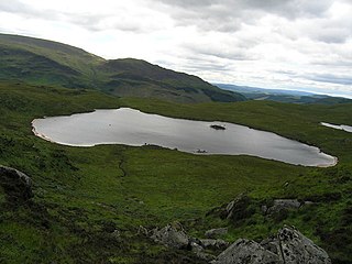
The Round Loch of Glenhead is a small upland single basin loch in Dumfries and Galloway. It is situated within Galloway Forest Park to the west of the hill Craiglee. It forms a pair with the nearby Long Loch of Glenhead. Both lochs are of similar sizes and each have a small island. The two lochs are separated from Loch Valley and Loch Naroch to the north by the Rig of the Jarkness. The loch is drained to the southwest by Round Loch Burn, which after joining into Glenhead Burn flows into Loch Trool.

Azas Nature Reserve is a Russian 'Zapovednik', located in the central part of the Todzha basin of south-central Asia about 500 km west of Lake Baikal. The reserve stretches along the Azas River, and is situated in the Todzhinsky District of Tuva.

Central Tsernozemsky Nature Reserve is a Russian 'zapovednik' that protects for scientific study a collection of selected sites of black soil prairie in the southwestern part of the Central Uplands within the middle of the forest-steppe zone. The six sites of the reserve spread out to the southeast of the city of Kursk, in the Medvensky District, Manturovsky District, Gorshechensky District of Kursk Oblast. Officially, the site is named after the biologist VV Alekhine. The reserve was created in 1935, and covers an area of 5,287 ha (20.41 sq mi). In 1978 it was included in the World Network of Biosphere Reserves.

Khanka Nature Reserve is a Russian 'zapovednik' that covers portions of the shore and waters of Lake Khanka, the largest freshwater lake in the Russian Far East. It is an important area for nesting and migrating waterfowl and other birds. The reserve is divided into five distinct sectors on the southern and eastern shores of the lake. The reserve is situated in the Spassky District, in the southwest of Primorsky Krai. It was formally established in 1990, and covers an area of 437 km2 (169 sq mi). It is part of a UNESCO Biosphere Reserve.

Lower Sula National Nature Park is a national park of Ukraine that covers the lower reaches of the Sula River as it enters the Kremenchuk Reservoir, 120 km southeast of Kyiv. The extensive marshes, swamps, and other wetlands of the area are important habitats for fish, waterfowl, and floodplain plants. The park is administratively in the Hlobyne, Orzhytsia, and Semenivka raions of Poltava Oblast, and Zolotonosha Raion of Cherkasy Oblast.

Polissia Nature Reserve is a protected nature reserve of Ukraine dedicated to the conservation and scientific study of representative woodland marshes of the Pinsk Marshes in the Polissia region. The reserve is in the administrative districts of Olevsk and Ovruch in Zhytomyr Oblast

Cheremske Nature Reserve is a protected nature reserve of Ukraine that covers forest and wetlands of the Western Polesia region, in the northwest of the country. The area is one of high biodiversity because of the varied habitat in transitional ecological zones. The reserve is in the administrative district of Manevychi in Volyn Oblast
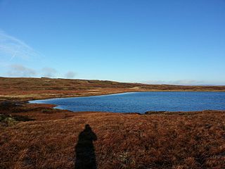
Fountains Fell Tarn, is an upland lake between the two peaks of Fountains Fell, in North Yorkshire, England. The tarn is close to the Pennine Way, some 4.3 miles (7 km) north west of Malham Tarn, and 4.3 miles (7 km) east of Horton in Ribblesdale. Water from the tarn flows eastwards through Cowside Beck, which is a tributary of the River Skirfare in Littondale. Whilst the water in the lake is acidic, as it runs off the mountain, it flows over Yoredale beds limestone and so becomes a harder water.


