
The Monongahela National Forest is a national forest located in the Allegheny Mountains of eastern West Virginia, US. It protects over 921,000 acres of federally managed land within a 1,700,000 acres proclamation boundary that includes much of the Potomac Highlands Region and portions of 10 counties.

The George Washington and Jefferson National Forests is an administrative entity combining two U.S. National Forests into one of the largest areas of public land in the Eastern United States. The forests cover 1.8 million acres (2,800 sq mi) of land in the Appalachian Mountains of Virginia, West Virginia, and Kentucky. Approximately 1 million acres (1,600 sq mi) of the forest are remote and undeveloped and 139,461 acres (218 sq mi) have been designated as wilderness areas, which prohibits future development.

The Conecuh National Forest in southern Alabama covers 83,000 acres (340 km2), along the Alabama - Florida line in Covington and Escambia counties. Topography is level to moderately sloping, broad ridges with stream terraces and broad floodplains.
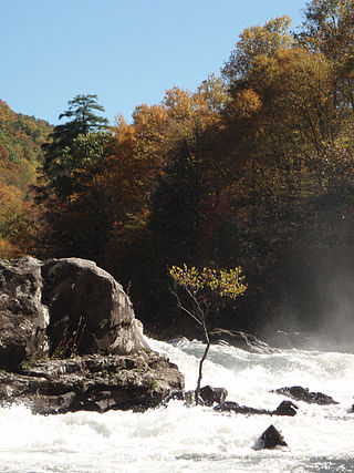
The Gauley River is a 105-mile-long (169 km) river in West Virginia. It merges with the New River to form the Kanawha River, a tributary of the Ohio River. The river features numerous recreational whitewater areas, including those in Gauley River National Recreation Area downstream of the Summersville Dam.

Prince William Forest Park is a National Park Service (NPS) site in the U.S. state of Virginia within Prince William County, located adjacent to the Marine Corps Base Quantico near the town of Dumfries. Established as Chopawamsic Recreational Demonstration Area in 1936, the park is the largest protected natural area in the Washington, D.C. metropolitan region at over 13,000 acres (5,300 ha).

Seneca Rocks is a large crag and local landmark in Pendleton County in the Eastern Panhandle of West Virginia, United States. The south peak is the only peak inaccessible except by technical rock climbing techniques on the East Coast of the United States. One of the best-known scenic attractions in West Virginia, the sheer rock faces are a popular challenge for rock climbers.
The Potomac Highlands of West Virginia centers on five West Virginian counties in the upper Potomac River watershed in the western portion of the state's eastern panhandle, bordering Maryland and Virginia. Because of geographical proximity, similar topography and landscapes, and shared culture and history, the Potomac Highlands region is also considered to include Pocahontas, Randolph, and Tucker Counties, even though they are in the Monongahela River or New River watersheds and not the Potomac River watershed.

Seneca Rocks is an unincorporated community located in Pendleton County, West Virginia, United States. The community of Seneca Rocks — formerly known as Mouth of Seneca — lies at the junction of US 33, WV 28 and WV 55 near the confluence of Seneca Creek and the North Fork South Branch Potomac River. The community also lies near Seneca Rocks, the crag from which it takes its name. Both lie within the Spruce Knob–Seneca Rocks National Recreation Area of the Monongahela National Forest.

Kanawha State Forest is a 9,300-acre (38 km2) recreation area located near the community of Loudendale, West Virginia, which is about 7 miles (11 km) from downtown Charleston, West Virginia, United States. It is managed by the West Virginia Department of Natural Resources.

Prickett's Fort State Park is a 188-acre (76.1 ha) West Virginia state park north of Fairmont, near the confluence of Prickett's Creek and the Monongahela River. The park features a reconstructed refuge fort and commemorates life on the Virginia frontier during the late 18th century.

Coopers Rock State Forest is a 12,747-acre (52 km2) state forest in Monongalia and Preston counties in the U.S. state of West Virginia. Its southern edge abuts Cheat Lake and the canyon section of Cheat River, a popular whitewater rafting river in the eastern United States.

White Top is a knob and spur of Cheat Mountain in southeastern Randolph County, West Virginia, USA. Sitting at an elevation of 4,085 feet (1,245 m), it is located just west of the Shavers Fork of Cheat River and Cheat Bridge. While White Top was originally crossed by the Staunton–Parkersburg Turnpike, modern-day U.S. Route 250 skirts the base of the knob beside Shavers Fork to the north and east.
Bulltown is an extinct town in Braxton County, West Virginia, United States. The GNIS classifies it as a populated place.

Spruce Mountain, located in eastern West Virginia, is the highest ridge of the Allegheny Mountains. The whale-backed ridge extends for only 16 miles (26 km) from northeast to southwest, but several of its peaks exceed 4,500 feet (1,400 m) in elevation. The summit, Spruce Knob, is the highest Allegheny Mountain point both in the state and the entire range, which spans four states.

Middle Mountain Cabins are a set of three historic cabins located in the Monongahela National Forest near Wymer, Randolph County, West Virginia. They were built in 1931, and consist of the Main Cabin and Cabins 1 and 2. The Main Cabin is a one-story, rectangular, stained log building measuring approximately 22 feet by 20 feet. It has a gable roof and full-length porch. Cabins 1 and 2 are mirror-images of each other. They are one-story, frame buildings with gable roofs measuring approximately 25 feet by 14 feet. They were built to provide quarters for fire lookouts and to serve as a base for conducting other Forest Service operations. They have since been converted for recreational use, and are available for rental as a group.

The Goodwill Historic District, Chopawamsic RDA Camp 1 near Triangle, Virginia dates from 1934. It has also been known as Prince William Forest Park, as Camp Lichtman, and as Boys' Camp. It was listed as a historic district on the National Register of Historic Places on June 12, 1989. The listing included eight contributing buildings, one contributing structure and one contributing site on 13 acres (5.3 ha).

The Big Draft Wilderness is a 5,144-acre (2,082 ha) U.S. Wilderness area in the Monongahela National Forest of southeast West Virginia, USA. Its name derives from the nearby Big Draft, a tributary of Anthony Creek which is a tributary of the Greenbrier River. Big Draft Wilderness occupies the southernmost acreage of the Monongahela National Forest and is located just south of the Blue Bend Recreation Area. The town White Sulphur Springs lies about 5 miles south of the Wilderness and about 15 miles northeast of Lewisburg.

The GW Jeep Site is an archaeological site which spans the border between Pocahontas County, West Virginia, and Highland County, Virginia. The site is located in two national forests; the West Virginia portion is within the Monongahela National Forest, while the Virginia portion is within the George Washington National Forest. A Native American camp where stone tools were made was located at the site between 1,000 and 5,000 years ago. The site was named after a Jeep owned by the George Washington National Forest, which was in the area when forest employees first noted the site.

Booker T. Washington State Park is a former state park near the community of Institute in the U.S. state of West Virginia. The park was operated by the West Virginia Conservation Commission, Division of State Parks, from 1949 until the late 1950s.

