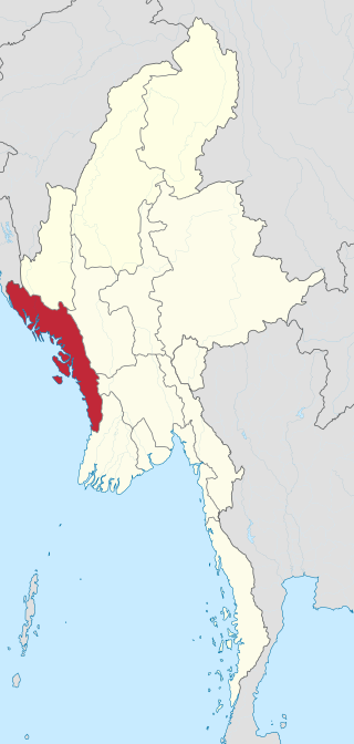
Rakhine State, formerly known as Arakan State, is a state in Myanmar (Burma). Situated on the western coast, it is bordered by Chin State to the north, Magway Region, Bago Region and Ayeyarwady Region to the east, the Bay of Bengal to the west and the Chittagong Division of Bangladesh to the northwest. It is located approximately between latitudes 17°30' north and 21°30' north and longitudes 92°10' east and 94°50' east. The Arakan Mountains or Rakhine Yoma separated Rakhine State from central Burma from North to South. Off the coast of Rakhine State there are some fairly large islands such as Ramree, Cheduba and Myingun. Rakhine State has an area of 36,762 square kilometres (14,194 sq mi) and its capital is Sittwe.

Myanmar is divided into 21 administrative divisions, which include seven regions, seven states, one union territory, one self-administered division, and five self-administered zones.

Myeik is a rural city in Tanintharyi Region, Myanmar, located in the extreme south of the country on the coast off an island on the Andaman Sea. As of 2010, the estimated population was over 209,000. Myeik is the largest city in Tanintharyi Region, and serves as the regional headquarters of Myanmar Navy's Tanintharyi Regional Command. The area inland from the city is a major smuggling corridor into Thailand. The Singkhon Pass, also known as the Maw-daung Pass, has an international cross-border checkpoint.
Tanintharyi or Taninthayi is a small town in Tanintharyi Township, Myeik District, in the Tanintharyi Region of south-western Myanmar. It is the administrative seat for the township. The town is located on the Great Tenasserim River which eventually enters the sea at Myeik. The town is located at the confluence of this river and a tributary known as the "Little Tenasserim River" which runs south.

Kawthaung is a border town located in the southernmost part of Myanmar, in the Tanintharyi Region. During British rule in Burma between 1824 and 1948, it was known as Victoria Point. As of 2021, it has a population of 57,949. Facing Ranong in Thailand, Kawthaung is one of 7 official border trade posts with Thailand.
Bokepyin is a town in Taninthayi Division, Myanmar.

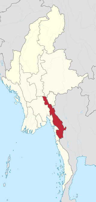
Tanintharyi Region is a region of Myanmar, covering the long narrow southern part of the country on the northern Malay Peninsula, reaching to the Kra Isthmus. It borders the Andaman Sea to the west and the Tenasserim Hills, beyond which lie Thailand, to the east. To the north is the Mon State. There are many islands off the coast, the large Mergui Archipelago in the southern and central coastal areas and the smaller Moscos Islands off the northern shores. The capital of the division is Dawei (Tavoy). Other important cities include Myeik (Mergui) and Kawthaung. The division covers an area of 43,344.9 square kilometres (16,735.6 sq mi), and had a population of 1,406,434 at the 2014 Census.

Thayetchaung Township is a township of Dawei District in the Taninthayi Division of Burma (Myanmar). The principal town is Thayetchaung.

Taninthayi Township is a township of Myeik District in the Taninthayi Division of Myanmar. The principal town is Taninthayi.

Palaw Township is a township of Myeik District in the Taninthayi Region of Burma (Myanmar). The principal town and administrative seat is Palaw. The township has two other towns - Palauk and Pala.
Myeik District is a district in the Tanintharyi Region of Burma (Myanmar). The district covers an area of 18,121 km2, and had a population of 693,087 at the 2014 Census.

Kawthoung District is a district of Tanintharyi Region, Myanmar. The district covers an area of 9,178 km2, and had a population of 221,738 at the 2014 census.
Burmese Malays, primarily live in Tanintharyi Region in the southern part of Myanmar. There are some dispersed Malay from the northernmost states of Malaysia and from southern Thailand. They are believed to be of Kedahan Malay descent. Some of the Moken people in the Mergui Archipelago speak a dialect of Malay.

Launglon is a town in Dawei District, in Tanintharyi Division, Burma. It is about 13 miles from Dawei.
Palauk is a town in Palaw Township, Taninthayi Region, Myanmar. It is located on the main coastal road, Route 8, between Dawei and Palaw. Palauk is the administrative seat of the Palauk Subtownship.
Tanintharyi may refer to:
Kayin State, formerly known as Karen State, is a state of Myanmar. The capital city is Hpa-An, also spelled Pa-An.

Lei Lei Maw is a Burmese politician and a medical doctor who served as Chief Minister of Tanintharyi Region and Taninthayi Region Parliament MP for Thayetchaung Township Constituency No. 1. She was removed from her chief minister position for corruption on 11 March 2019. She is one of only two women chief ministers appointed by President Htin Kyaw. People called her Jayalalitha of Myanmar.
The Karen–Mon conflict is a series of armed clashes between the ethnic rebel armies of the Karen and Mon peoples. The Karen National Liberation Army and the Mon National Liberation Army have clashed sporadically since 1988, mostly around the Myanmar–Thailand border at Three Pagodas Pass.
Myint Maung is a Burmese politician who currently serves as Chief Minister of Taninthayi Region and Taninthayi Region Parliament MP for Kawthaung Township Constituency No. 2.


