The German Empire, also known as Imperial Germany, was the German nation state that existed from the unification of Germany in 1871 until the abdication of Kaiser Wilhelm II in 1918.

The Germany national football team is the men's football team that has represented Germany in international competition since 1908. It is governed by the German Football Association, founded in 1900. Ever since the DFB was reinaugurated in 1949 the team has represented the Federal Republic of Germany. Under Allied occupation and division, two other separate national teams were also recognised by FIFA: the Saarland team representing the Saarland (1950–1956) and the East German team representing the German Democratic Republic (1952–1990). Both have been absorbed along with their records by the current national team. The official name and code "Germany FR (FRG)" was shortened to "Germany (GER)" following the reunification in 1990.

The Our is a river in Belgium, Luxembourg and Germany. It is a left-hand tributary of the river Sauer/Sûre. Its total length is 78 kilometres (48 mi).

Limburger Domsingknaben is the name of the boys' choir at the Limburg Cathedral in Limburg, Hesse, Germany. The choir was founded in 1967 by the then bishop of Limburg, Wilhelm Kempf. Its conductors were Hans Bernhard, Mathias Breitschaft, Klaus Knubben and, since 2014, Andreas Bollendorf.

Berdorf is a commune and small town in eastern Luxembourg. It is part of the canton of Echternach, which is part of the district of Grevenmacher. Berdorf is known for the sandstone rocks surrounding it.

World War I, also known as the First World War or the Great War, was a global war originating in Europe that lasted from 28 July 1914 to 11 November 1918. Contemporaneously described as "the war to end all wars", it led to the mobilisation of more than 70 million military personnel, including 60 million Europeans, making it one of the largest wars in history. It is also one of the deadliest conflicts in history, with an estimated nine million combatants and seven million civilian deaths as a direct result of the war, while resulting genocides and the 1918 influenza pandemic caused another 50 to 100 million deaths worldwide.
Bollendorf-Pont is a village in the commune of Berdorf, in eastern Luxembourg. As of 2001, the village had a population of 165. It lies opposite the German town of Bollendorf.

The Holocaust, also known as the Shoah, was a genocide during World War II in which Nazi Germany, aided by local collaborators, systematically murdered some six million European Jews—around two-thirds of the Jewish population of Europe—between 1941 and 1945. Jews were targeted for extermination as part of a larger event during the Holocaust era, in which Germany and its collaborators persecuted and murdered other groups, including Slavs, the Roma, the "incurably sick", political and religious dissenters such as communists and Jehovah's Witnesses, and gay men. Taking into account all the victims of Nazi persecution, the death toll rises to over 17 million.

Bykowo is a village in the administrative district of Gmina Korsze, within Kętrzyn County, Warmian-Masurian Voivodeship, in northern Poland. It lies approximately 6 kilometres (4 mi) north-west of Korsze, 24 km (15 mi) north-west of Kętrzyn, and 63 km (39 mi) north-east of the regional capital Olsztyn.
The South Eifel refers to that part of the Eifel mountain region around the Bitburg-Prüm district in the German state of Rhineland-Palatinate.
The following is a list of Luxembourgish exonyms, that is to say names for towns and cities that do not speak Luxembourgish that have been adapted to Luxembourgish standard spelling rules, or are simply native names from ancient times.
The LRAC de 73mm Mle 1950 was a French antitank rocket launcher produced and fielded in the 1950s. The LRAC fired a 73-mm high explosive antitank projectile that was capable of penetrating over 11 inches of rolled homogenous armor when struck at a 90-degree angle of impact. The LRAC 73-50 was replaced in French service by the 3.5-inch M20 Bazooka. Used during the Korean War for the French Battalion of the United Nations Organisation, it pierced the armor of T-34 tanks.
Südeifel is a Verbandsgemeinde in the district Bitburg-Prüm, in Rhineland-Palatinate, Germany. The seat of the Verbandsgemeinde is in Neuerburg. It was formed on 1 July 2014 by the merger of the former Verbandsgemeinden Irrel and Neuerburg.

The Ferschweiler Plateau, which is home to the villages of Ferschweiler and Ernzen among others, is an extensive highland area made from sandstone and is located in the collective municipality of Irrel in the county of Bitburg-Prüm in the German state of Rhineland-Palatinate. From a landscape perspective the Ferschweiler Plateau lies within the South Eifel, a region in the Eifel Mountains.

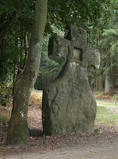
The Fraubillen cross is a menhir, which has been resculpted into a cross. It stands by a wayside on the Ferschweiler Plateau in the Eifel mountains in Germany, between Ferschweiler, Schankweiler, Nusbaum-Rohrbach and Bollendorf.


