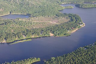
The Fond du Lac River is one of the upper branches of the Mackenzie River system, draining into the Arctic Ocean, located in northern Saskatchewan, Canada. The river is 277 kilometres (172 mi) long, has a watershed of 66,800 square kilometres (25,792 sq mi), and its mean discharge is 300 cubic metres per second (10,594 cu ft/s).

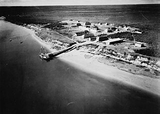
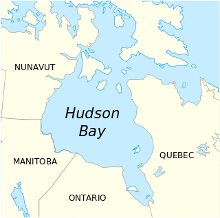
The Hayes River is a river in Northern Region, Manitoba, Canada that flows from Molson Lake to Hudson Bay at York Factory. It was an historically important river in the development of Canada, and is today a Canadian Heritage River and the longest naturally flowing river in Manitoba.

The Magpie River is a river in Algoma District, northeastern Ontario, Canada, The river empties into Michipicoten Bay on Lake Superior near the town of Wawa. The river drains an area of about 1,900 square kilometres (734 sq mi).

Winisk Lake is a large, irregularly-shaped lake in the Winisk River and Hudson Bay drainage basins in northern Kenora District in northwestern Ontario, Canada.

The Mink River is a river in the Hudson Bay drainage basin in Census Division No. 22 - Thompson-North Central, Northern Region, Manitoba, Canada. It is about 14.7 kilometres (9.1 mi) long and begins at Aswapiswanan Lake at an elevation of 186 metres (610 ft). The river takes in one significant tributary, an unnamed river from the Colen Lakes, from the left at 54°29′57″N95°13′06″W before emptying into Touchwood Lake at an elevation of 184 metres (604 ft). The Mink River's waters eventually flow into Gods Lake, and via the Gods River and the Hayes River into Hudson Bay.
Aswapiswanan Lake is a lake in the Hayes River drainage basin in Census Division No. 22 - Thompson-North Central, Northern Region, Manitoba, Canada. The lake is about 22 kilometres (14 mi) long and 2.6 kilometres (1.6 mi) wide and lies at an elevation of 186 metres (610 ft). The primary inflows from west to east are the Hungry River, Porcupine Creek, the Bolton River and the Joint River. The primary outflow is the Mink River. The lake's waters eventually flow into Gods Lake, and via the Gods River and the Hayes River into Hudson Bay.
Musketasonan Lake is a lake in the Hayes River drainage basin in Census Division No. 22 - Thompson-North Central, Northern Region, Manitoba, Canada. The lake is about 4.5 kilometres (2.8 mi) long and 1.6 kilometres (1.0 mi) wide and lies at an elevation of 249 metres (817 ft). It is the source of the Bolton River, whose waters eventually flow into Gods Lake, and via the Gods River and the Hayes River into Hudson Bay.
Touchwood Lake is a lake in the Hayes River drainage basin in Census Division No. 22 - Thompson-North Central, Northern Region, Manitoba, Canada. The lake is about 20.9 kilometres (13.0 mi) long and 4.4 kilometres (2.7 mi) wide and lies at an elevation of 184 metres (604 ft). The primary inflows are the Mink River, Wanless Creek, and the Wapawukaw River, and the primary outflow is a channel to Vermilyea Lake. The lake's waters eventually flow into Gods Lake, and via the Gods River and the Hayes River into Hudson Bay.
Vermilyea Lake is a lake in the Hayes River drainage basin in Census Division No. 22 - Thompson-North Central, Northern Region, Manitoba, Canada. It is shaped like the letter "L" on its side, is about 9.3 kilometres (5.8 mi) long and 8.2 kilometres (5.1 mi) wide, and lies at an elevation of 184 metres (604 ft). The primary inflow is a channel from Touchwood Lake, and the primary outflows are the twin channels of the Wesachewan River to Gods Lake. The lake's waters eventually flow via the Gods River and the Hayes River into Hudson Bay.

The Wesachewan River is a short river in the Hudson Bay drainage basin in Census Division No. 22 - Thompson-North Central, Northern Region, Manitoba, Canada. It flows 2.5 kilometres (1.6 mi) out of Vermilyea Lake via twin channels which combine at 54°30′31″N94°44′28″W, then flows over the Namaykos Rapids, and empties into Wesachewan Bay on Gods Lake. The main channel from Vermilyea Lake is the east channel, given as the primary source in the Infobox at right, which is straighter and 1.8 kilometres (1.1 mi) shorter than its twin, the west channel, given as the secondary source. The length of the river given in the Infobox is the length using the shorter east channel.

Bolton Lake is a lake in the James Bay drainage basin in the municipality of Black River-Matheson in Cochrane District, Ontario, Canada. It is about 1,200 metres (3,937 ft) long and 800 metres (2,625 ft) wide, and lies at an elevation of 288 metres (945 ft) near the community of Wavell, 1.3 kilometres (0.8 mi) northeast of Ontario Highway 11 and the Ontario Northland Railway main line, and 33 kilometres (21 mi) northwest of the town of Kirkland Lake. The primary outflow is Burdick creek to the Black River, which flows via the Abitibi River and the Moose River to James Bay.
Little Bolton Lake is a lake in the Hayes River drainage basin in Census Division No. 22 - Thompson-North Central, Northern Region, Manitoba, Canada. The lake is about 15 kilometres (9.3 mi) long and 4 kilometres (2.5 mi) wide and lies at an elevation of 224 metres (735 ft). The primary inflow and outflow is the Bolton River, whose waters eventually flow into Gods Lake, and via the Gods River and the Hayes River into Hudson Bay.
Bolton Lake is a lake in the Hayes River drainage basin in Census Division No. 22 - Thompson-North Central, Northern Region, Manitoba, Canada. The lake is at an elevation of 212 metres (696 ft); the main body of the lake is about 15 kilometres (9.3 mi) long and 8 kilometres (5.0 mi) wide, but an arm extends a further 11 kilometres (6.8 mi) for a total width of 19 km as well. The primary inflows are the Bolton River from the west and the Nikik River from the south, and the primary outflow is Bolton River, whose waters eventually flow into Gods Lake, and via the Gods River and the Hayes River into Hudson Bay.
Kakwusis Lake is a lake in the Hayes River drainage basin in Census Division No. 22 - Thompson-North Central, Northern Region, Manitoba, Canada. The lake is about 3.6 kilometres (2.2 mi) long and 1.6 kilometres (1.0 mi) wide and lies at an elevation of 208 metres (682 ft). The primary inflow and outflow is the Bolton River, whose waters eventually flow into Gods Lake, and via the Gods River and the Hayes River into Hudson Bay.
Rushforth Lake is a lake in the Hayes River drainage basin in Census Division No. 22 - Thompson-North Central, Northern Region, Manitoba, Canada. The lake is about 11 kilometres (6.8 mi) long and 1.4 kilometres (0.9 mi) wide and lies at an elevation of 218 metres (715 ft). The primary inflow and outflow is the Bolton River, whose waters eventually flow into Gods Lake, and via the Gods River and the Hayes River into Hudson Bay.

The Ekwan River is a river in Kenora District in northwestern Ontario, Canada. It travels about 500 kilometres (311 mi) from its source at Zumar Lake on the Canadian Shield, through the Hudson Bay Lowlands, northeast and then east, to its mouth on James Bay.

Bluejay Creek is a river in the east part of Thunder Bay District in northwestern Ontario, Canada. It is in the Lake Superior drainage basin and is a tributary of the Pic River.

The Whitefish River is a river in Census division No. 18 in northern Saskatchewan, Canada. It is in the Hudson Bay and Churchill River drainage basins.

Southern Indian Lake is a large lake in Manitoba, Canada. It has an area of 2,247 km2 (868 sq mi) with a surface elevation of 258 m (846 ft).

The Rivière de Puvirnituq is a river in Kativik, Nord-du-Québec, Quebec, Canada. The river flows 389 kilometres (242 mi) from its source at an unnamed lake to Hudson Bay at the village of Puvirnituq. Its watershed encompasses 28,500 square kilometres (11,000 sq mi). The name of the river comes from the Inuktitut "smells like rotten meat."


