
Manipal is a suburb and university town within Udupi, in coastal Karnataka, India. It is one of the cleanest towns in India. Manipal is located five kilometres away from the centre of Udupi City, in Udupi District, Karnataka (state) in south western India. It is administered by the Udupi City Municipality. The suburb is located in coastal Karnataka, 62 km north of Mangalore and 8 km east of the Arabian Sea. From its location on a plateau, at an altitude of about 75 m above sea level, it commands a panoramic view of the Arabian Sea to the west and the Western Ghats to the east.

Osmanabad, officially known as Dharashiv, is a city and a municipal council in Osmanabad district in the Indian state of Maharashtra. Osmanabad derived its name from the last ruler of Hyderabad, Mir Osman Ali Khan. This city is the administrative headquarter of Osmanabad district. It is the seventh largest city in Marathwada While 39th largest city in Maharashtra by population.
Ambaji (Ambājī) is a census town in Banaskantha district in the state of Gujarat, India. It is known for its historical connections with sites of cultural heritage.
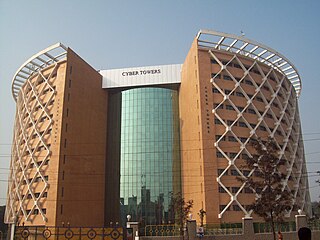
Madhapur is a suburb of Hyderabad, India. It is noted as a centre of information technology activity. The heart of this area is called HITEC City which has the highest concentration of IT/ITES establishments in the city. Located in Ranga Reddy district of Telangana, It is administered as Ward No. 107 of Greater Hyderabad Municipal Corporation.

Shamshabad is a city in the Indian state of Telangana. It is located in Shamshabad mandal of Rajendranagar revenue division. Sri Vendikonda Siddalingeshwara Devastanam temple is sitauted in Siddulagutta Road in Shamshabad mandal. The international airport of Hyderabad is located here.

Rajiv Gandhi International Airport is an international airport that serves Hyderabad, the capital of the Indian state of Telangana. It is located in Shamshabad, about 24 kilometres (15 mi) south of Hyderabad and it was opened on 23 March 2008 to replace Begumpet Airport, which was the sole civilian airport serving Hyderabad. It is named after Rajiv Gandhi, former Prime Minister of India. Built over an area of 5,500 acres (2,200 ha), it is the largest airport of India by area. It is owned and operated by GMR Hyderabad International Airport Limited (GHIAL), a public–private consortium. It has also ranked in AirHelp's list of top 10 airports in the world. The fourth busiest airport in India by passengers traffic, it handled over 12 million passengers and over 140,000 tonnes of cargo between both April 2021 and March 2022.
Nitte Meenakshi Institute of Technology (NMIT) is an autonomous engineering college in Bangalore, Karnataka, India affiliated to the Visvesvaraya Technological University, Belagavi.
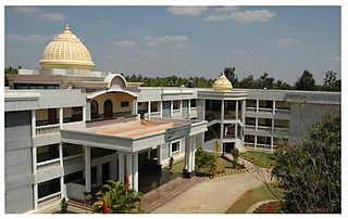
Sir Mokshagundam Visvesvaraya Institute of Technology is an Indian educational institution located in Bengaluru, Karnataka. The institute is affiliated to Visvesvaraya Technological University and approved by All India Council for Technical Education, New Delhi. Sir MVIT is an ISO 9001:2008 certified institution. It offers programs in the field of technical education.
Ichoda is a town in Adilabad district in the state of Telangana in India.
Chevella is a town, mandal and suburb of Hyderabad in Ranga Reddy district of the Indian state of Telangana. It is the headquarters of surrounding villages with many government establishments like Judicial court, Revenue Division Office, Acp office under Cyberabad Metropolitan Police. It is also an educational hub with many schools, junior colleges, engineering colleges, business schools etc. There are many hospitals located along with a medical college, the Dr. Patnam Reddy Institute of Medical Sciences. It has become a part of Hyderabad Metropolitan Development Authority.
S J C Institute of Technology (SJCIT), or in its full name Sri Jagadguru Chandrashekaranatha Swamiji Institute of Technology, is an Engineering college located in the city of Chikballapur, Chikballapur district, Karnataka, India, about 20 Kilometers from Bangalore International Airport. It was established in 1986 by the Sri Adichunchanagiri Shikshana Trust under Sri Balagangadharanatha Swamiji and is operated by that trust, which also operates various sister colleges across Karnataka. The college is affiliated to Visvesvaraya Technological University. The total area of the college campus is 53 acres (210,000 m2) with an instructional area of 23000 sq.m.it is one of the affiliated to VTU
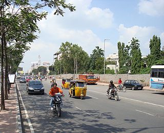
Sanjeeva Reddy Nagar or SR Nagar is predominantly a residential area in Hyderabad, Telangana, India. It is close to Ameerpet, a commercial suburb. It is named after the sixth President of India, Neelam Sanjeeva Reddy.
Jawaharnagar is a city of and a municipal corporation located in Medchal-Malkajgiri district in the Indian state of Telangana. It was upgraded to Municipal corporation in 2019. Previously, it was a part of Shamirpet mandal but now it falls under newly formed Kapra mandal.
Kondapur is a suburb in western part of Hyderabad, Telangana, India. It falls under Serilingampally mandal of Ranga Reddy district. The locality has emerged as a prominent commercial and residential hub, owing to its close proximity to IT corridor of Hyderabad. It is administered as Ward No. 104 of Greater Hyderabad Municipal Corporation.
Pedda Amberpet is a Municipality in Rangareddy district, Telangana, India. It comes under Hayathnagar Mandal.
Tukkuguda is a municipality in Rangareddy district, Telangana, India. It falls under Maheswaram mandal.

Sir Mokshagundam Visvesvaraya,, also referred to by his initials, MV, was an Indian civil engineer, administrator, and statesman, who served as the 19th Diwan of Mysore from 1912 to 1918.
Navodaya Institute of Technology (NIT) is a college in Raichur, India, under the VTU Visvesvaraya Technological University recognized by the Government of Karnataka and approved by the All India Council of Technical Education AICTE, New Delhi.
Dahitane is a village in Barshi Taluka of Solapur district in Maharashtra, India. The village is located between Town Vairag and Tehsil Mohol. Dahitane is a village panchayat located in the Solapur district of Maharashtra state, India. The latitude 18.0079127 and longitude 75.7683995 are the geocoordinate of the Dahitane. Mumbai is the state capital for Dahitane village. It is located around 328.5 kilometer away from Dahitane. The other nearest state capital from Dahitane is Hyderabad and its distance is 295.1 km. The other surrounding state capitals are Hyderabad 295.1 km, Daman 408.8 km, Bangalore 591.6 km.
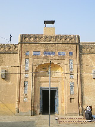
Dhingana, is a village/ town of Mankera Tehsil, of Bhakkar District, in the Punjab province of Pakistan. It is situated about 280 kilometers west of the city of Lahore.