Choszczno County is a unit of territorial administration and local government (powiat) in West Pomeranian Voivodeship, north-western Poland. It came into being on January 1, 1999, as a result of the Polish local government reforms passed in 1998. Its administrative seat and largest town is Choszczno, which lies 62 kilometres (39 mi) south-east of the regional capital Szczecin. The county contains three other towns: Recz, 15 km (9 mi) north-east of Choszczno, Pełczyce, 16 km (10 mi) south-west of Choszczno, and Drawno, 24 km (15 mi) east of Choszczno.
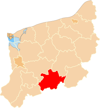
Gmina Drawno is an urban-rural gmina in Choszczno County, West Pomeranian Voivodeship, in north-western Poland. Its seat is the town of Drawno, which lies approximately 24 kilometres (15 mi) east of Choszczno and 81 km (50 mi) east of the regional capital Szczecin.

Barnimie is a village in the administrative district of Gmina Drawno, within Choszczno County, West Pomeranian Voivodeship, in north-western Poland. It lies approximately 7 kilometres (4 mi) south-east of Drawno, 27 km (17 mi) east of Choszczno, and 86 km (53 mi) east of the regional capital Szczecin.

Brzeziny is a village in the administrative district of Gmina Drawno, within Choszczno County, West Pomeranian Voivodeship, in north-western Poland. It lies approximately 10 kilometres (6 mi) south-west of Drawno, 20 km (12 mi) east of Choszczno, and 80 km (50 mi) east of the regional capital Szczecin.
Dobrojewo is a village in the administrative district of Gmina Drawno, within Choszczno County, West Pomeranian Voivodeship, in north-western Poland. It lies approximately 2 kilometres (1 mi) north-west of Drawno, 24 km (15 mi) east of Choszczno, and 80 km (50 mi) east of the regional capital Szczecin.

Dominikowo is a village in the administrative district of Gmina Drawno, within Choszczno County, West Pomeranian Voivodeship, in north-western Poland. It lies approximately 6 kilometres (4 mi) east of Drawno, 30 km (19 mi) east of Choszczno, and 87 km (54 mi) east of the regional capital Szczecin.
Drawnik is a village in the administrative district of Gmina Drawno, within Choszczno County, West Pomeranian Voivodeship, in north-western Poland. It lies approximately 2 kilometres (1 mi) south-east of Drawno, 25 km (16 mi) east of Choszczno, and 82 km (51 mi) east of the regional capital Szczecin.
Jaźwiny is a village in the administrative district of Gmina Drawno, within Choszczno County, West Pomeranian Voivodeship, in north-western Poland. It lies approximately 12 kilometres (7 mi) south-east of Drawno, 33 km (21 mi) east of Choszczno, and 92 km (57 mi) east of the regional capital Szczecin.
Kawczyn is a village in the administrative district of Gmina Drawno, within Choszczno County, West Pomeranian Voivodeship, in north-western Poland. It lies approximately 3 kilometres (2 mi) north of Drawno, 25 km (16 mi) east of Choszczno, and 81 km (50 mi) east of the regional capital Szczecin.
Kępa is a village in the administrative district of Gmina Drawno, within Choszczno County, West Pomeranian Voivodeship, in north-western Poland. It lies approximately 3 kilometres (2 mi) north-west of Drawno, 24 km (15 mi) east of Choszczno, and 80 km (50 mi) east of the regional capital Szczecin.
Kolonia Kniewo is a village in the administrative district of Gmina Drawno, within Choszczno County, West Pomeranian Voivodeship, in north-western Poland. It lies approximately 2 kilometres (1 mi) west of Drawno, 23 km (14 mi) east of Choszczno, and 80 km (50 mi) east of the regional capital Szczecin.
Konotop is a village in the administrative district of Gmina Drawno, within Choszczno County, West Pomeranian Voivodeship, in north-western Poland. It lies approximately 10 kilometres (6 mi) south-east of Drawno, 30 km (19 mi) east of Choszczno, and 89 km (55 mi) east of the regional capital Szczecin.
Maciejów is a village in the administrative district of Gmina Drawno, within Choszczno County, West Pomeranian Voivodeship, in north-western Poland. It lies approximately 3 kilometres (2 mi) north-west of Drawno, 24 km (15 mi) east of Choszczno, and 80 km (50 mi) east of the regional capital Szczecin.
Niemieńsko is a village in the administrative district of Gmina Drawno, within Choszczno County, West Pomeranian Voivodeship, in north-western Poland. It lies approximately 9 kilometres (6 mi) south-east of Drawno, 31 km (19 mi) east of Choszczno, and 89 km (55 mi) east of the regional capital Szczecin. Before 1945 the village was German-settled and part of the German state of Prussia.
Rogoźnica is a village in the administrative district of Gmina Drawno, within Choszczno County, West Pomeranian Voivodeship, in north-western Poland. It lies approximately 18 kilometres (11 mi) south-east of Drawno, 38 km (24 mi) east of Choszczno, and 98 km (61 mi) east of the regional capital Szczecin.
Rościn is a village in the administrative district of Gmina Drawno, within Choszczno County, West Pomeranian Voivodeship, in north-western Poland. It lies approximately 7 kilometres (4 mi) north of Drawno, 28 km (17 mi) north-east of Choszczno, and 81 km (50 mi) east of the regional capital Szczecin.
Sieniawa is a village in the administrative district of Gmina Drawno, within Choszczno County, West Pomeranian Voivodeship, in north-western Poland. It lies approximately 4 kilometres (2 mi) east of Drawno, 28 km (17 mi) east of Choszczno, and 84 km (52 mi) east of the regional capital Szczecin.
Wiśniewo is a village in the administrative district of Gmina Drawno, within Choszczno County, West Pomeranian Voivodeship, in north-western Poland. It lies approximately 3 kilometres (2 mi) east of Drawno, 27 km (17 mi) east of Choszczno, and 83 km (52 mi) east of the regional capital Szczecin.
Zacisze is a village in the administrative district of Gmina Drawno, within Choszczno County, West Pomeranian Voivodeship, in north-western Poland. It lies approximately 3 kilometres (2 mi) west of Drawno, 22 km (14 mi) east of Choszczno, and 79 km (49 mi) east of the regional capital Szczecin.
Brac is a village in the administrative district of Gmina Drawno, within Choszczno County, West Pomeranian Voivodeship, in north-western Poland. It lies approximately 3 kilometres (2 mi) north-west of Drawno, 23 km (14 mi) east of Choszczno, and 79 km (49 mi) east of the regional capital Szczecin.

