Shilka is a town and the administrative center of Shilkinsky District in Zabaykalsky Krai, Russia, located on the Shilka River, 248 kilometers (154 mi) east of Chita, the administrative center of the krai. Population: 13,947 (2010 Census); 14,748 (2002 Census); 18,057 (1989 Census).
Akshinsky District is an administrative and municipal district (raion), one of the thirty-one in Zabaykalsky Krai, Russia. It is located in the south of the krai and borders with Ononsky, Ulyotovsky, and Kyrinsky Districts of Zabaykalsky Krai, as well as with Mongolia. The area of the district is 7,400 square kilometers (2,900 sq mi). Administrative center is the rural locality of Aksha. Population: 10,682 (2010 Census); 12,080 ; 14,695 (1989 Census). The population of Aksha accounts for 36.9% of the district's total population.

Tungiro-Olyokminsky District is an administrative and municipal district (raion), one of the thirty-one in Zabaykalsky Krai, Russia. It is located in the northeast of the krai, and borders with Kalarsky District in the north, Mogochinsky District in the south, and with Tungokochensky District in the west. The area of the district is 42,900 square kilometers (16,600 sq mi). Its administrative center is the rural locality of Tupik. Population: 1,432 (2010 Census); 1,643 ; 1,899 (1989 Census). The population of Tupik accounts for 67.8% of the district's total population.

Karymsky District is an administrative and municipal district (raion), one of the thirty-one in Zabaykalsky Krai, Russia. It is located in the center of the krai and borders Tungokochensky District in the north, Shilkinsky District in the east, Aginsky District in the south, and Chitinsky District in the west. The area of the district is 7,800 square kilometers (3,000 sq mi). Its administrative center is the urban locality of Karymskoye. As of the 2010 Census, the total population of the district was 37,161, with the population of Karymskoye accounting for 35.1% of that number.
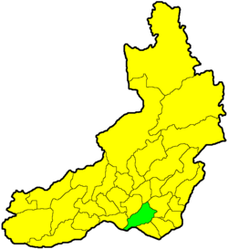
Baleysky District is an administrative and municipal district (raion), one of the thirty-one in Zabaykalsky Krai, Russia. It is located in the southern central part of the krai, and borders Nerchinsky District in the north, Shelopuginsky District in the east, Borzinsky District in the south, and with Olovyanninsky District in the west. The area of the district is 5,000 square kilometers (1,900 sq mi). Its administrative center is the town of Baley. As of the 2010 Census, the total population of the district was 20,500, with the population of Baley accounting for 61.1% of that number.
Kalgansky District is an administrative and municipal district (raion), one of the thirty-one in Zabaykalsky Krai, Russia. It is located in the southeast of the krai and borders Nerchinsko-Zavodsky District in the north, Priargunsky District in the south, and Alexandrovo-Zavodsky District in the west. The area of the district is 2,900 square kilometers (1,100 sq mi). Its administrative center is the rural locality of Kalga. As of the 2010 Census, the total population of the district was 8,771, with the population of Kalga accounting for 39.1% of that number.

Krasnochikoysky District is an administrative and municipal district (raion), one of the thirty-one in Zabaykalsky Krai, Russia. It is located in the southwest of the krai, and borders with Khiloksky District in the north, Ulyotovsky District in the east, and Kyrinsky District in the south. The area of the district is 28,600 square kilometers (11,000 sq mi). Its administrative center is the rural locality of Krasny Chikoy. Population: 19,453 (2010 Census); 21,576 ; 23,061 (1989 Census). The population of Krasny Chikoy accounts for 36.3% of the district's total population.

Krasnokamensky District is an administrative and municipal district (raion), one of the thirty-one in Zabaykalsky Krai, Russia. It is located in the southeast of the krai, and borders with Priargunsky District in the north, and with Zabaykalsky District in the west. The area of the district is 5,300 square kilometers (2,000 sq mi). Its administrative center is the town of Krasnokamensk. Population: 64,597 (2010 Census); 9,987 ; 71,037 (1989 Census). The population of Krasnokamensk accounts for 86.2% of the district's total population.
Kyrinsky District is an administrative and municipal district (raion), one of the thirty-one in Zabaykalsky Krai, Russia. It is located in the southwest of the krai, and borders with Ulyotovsky District in the north. The area of the district is 16,200 square kilometers (6,300 sq mi). Its administrative center is the rural locality of Kyra. Population: 13,650 (2010 Census); 16,016 ; 19,593 (1989 Census). The population of Kyra accounts for 33.4% of the district's total population.

Mogochinsky District is an administrative and municipal district (raion), one of the thirty-one in Zabaykalsky Krai, Russia. It is located in the east of the krai and borders China in the east and south. The area of the district is 25,500 square kilometers (9,800 sq mi). Its administrative center is the town of Mogocha. As of the 2010 Census, the total population of the district was 25,508, with the population of Mogocha accounting for 52.0% of that number.

Nerchinsko-Zavodsky District is an administrative and municipal district (raion), one of the thirty-one in Zabaykalsky Krai, Russia. It is located in the east and southeast of the krai, and borders with Gazimuro-Zavodsky District in the north, and Kalgansky District in the south. The area of the district is 9,700 square kilometers (3,700 sq mi). Its administrative center is the rural locality of Nerchinsky Zavod. Population: 10,782 (2010 Census); 12,499 ; 15,605 (1989 Census). The population of Nerchinsky Zavod accounts for 26.4% of the district's total population.
Olovyanninsky District is an administrative and municipal district (raion), one of the thirty-one in Zabaykalsky Krai, Russia. It is located in the south of the krai, and borders with Baleysky District in the north, Borzinsky District in the south, and with Mogoytuysky District in the west. The area of the district is 6,300 square kilometers (2,400 sq mi). Its administrative center is the urban locality of Olovyannaya. Population: 43,494 (2010 Census); 49,426 ; 60,810 (1989 Census). The population of Olovyannaya accounts for 19.3% of the district's total population.

Ononsky District is an administrative and municipal district (raion), one of the thirty-one in Zabaykalsky Krai, Russia. It is located in the south of the krai, and borders Aginsky District in the north, Borzinsky District in the east, and Akshinsky District in the west. The area of the district is 5,800 square kilometers (2,200 sq mi). Its administrative center is the rural locality of Nizhny Tsasuchey. As of the 2010 Census, the total population of the district was 11,199, with the population of Nizhny Tsasuchey accounting for 30.0% of that number.
Sretensky District is an administrative and municipal district (raion), one of the thirty-one in Zabaykalsky Krai, Russia. It is located in the east of the krai, and borders with Mogochinsky District in the north, Gazimuro-Zavodsky District in the east, and with District in the west. The area of the district is 15,600 square kilometers (6,000 sq mi). Its administrative center is the town of Sretensk. Population: 23,311 (2010 Census); 27,524 ; 33,236 (1989 Census). The population of Sretensk accounts for 29.4% of the district's total population.

Tungokochensky District is an administrative and municipal district (raion), one of the thirty-one in Zabaykalsky Krai, Russia. It is located in the central northern part of the krai, and borders with Kalarsky District in the north, Tungiro-Olyokminsky District in the east, and with Chernyshevsky District in the south. The area of the district is 50,900 square kilometers (19,700 sq mi). Its administrative center is the rural locality of Verkh-Usugli. Population: 12,685 (2010 Census); 14,207 ; 19,357 (1989 Census). The population of Verkh-Usugli accounts for 20.7% of the district's total population.

Mogoytuysky District is an administrative and municipal district (raion) of Agin-Buryat Okrug of Zabaykalsky Krai, Russia, one of the thirty-one in the krai, and borders with Shilkinsky District in the north, Olovyanninsky District in the east, Ononsky District in the south, and with Aginsky District in the west. The area of the district is 6,300 square kilometers (2,400 sq mi). Its administrative center is the urban locality of Mogoytuy. Population: 27,463 (2010 Census); 27,386 ; 28,647 (1989 Census). The population of Mogoytuy accounts for 37.3% of the district's total population.

Aksyonovo-Zilovskoye is an urban locality in Chernyshevsky District of Zabaykalsky Krai, Russia. Population: 3,443 (2010 Census); 4,283 (2002 Census); 5,904 (1989 Census).
Sherlovaya Gora is an urban locality in Borzinsky District of Zabaykalsky Krai, Russia. Population: 12,489 (2010 Census); 14,623 (2002 Census); 17,509 (1989 Census).
Bukachacha is an urban locality in Chernyshevsky District of Zabaykalsky Krai, Russia. Population: 2,359 (2010 Census); 3,525 (2002 Census); 7,941 (1989 Census).
Novopavlovka is an urban locality in Petrovsk-Zabaykalsky District of Zabaykalsky Krai, Russia. Population: 3,941 (2010 Census); 4,288 (2002 Census); 4,775 (1989 Census).