
The Saône is a river of eastern France. It is a right tributary of the Rhône, rising at Vioménil in the Vosges department and joining the Rhône in Lyon, at the southern end of the Presqu'île.

The Aude is a river of southern France that is 224 kilometres (139 mi) long. Its source is in the Pyrenees mountains then runs to Carcassonne and finally reaches the Mediterranean Sea near Narbonne. The river is navigable by raft or canoe for nearly all of its length. It is registered as essential to the Languedoc-Roussillon region.

The Moselle is a river that rises in the Vosges mountains and flows through north-eastern France and Luxembourg to western Germany. It is a left bank tributary of the Rhine, which it joins at Koblenz. A small part of Belgium is in its basin as it includes the Sauer and the Our.
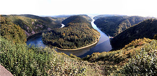
The Saar is a river in northeastern France and western Germany, and a right tributary of the Moselle. It rises in the Vosges mountains on the border of Alsace and Lorraine and flows northwards into the Moselle near Trier. It has two headstreams, that both start near Mont Donon, the highest peak of the northern Vosges. After 246 kilometres (153 mi) the Saar flows into the Moselle at Konz (Rhineland-Palatinate) between Trier and the Luxembourg border. It has a catchment area of 7,431 square kilometres (2,869 sq mi).

The Orne is a river in Grand Est, north-eastern France, which is a left tributary of the Moselle and sub-tributary of the Rhine. Its source is in the hills northeast of Verdun. It flows east and joins the Moselle near Mondelange, between Metz and Thionville.

The arrondissement of Saint-Dié-des-Vosges is an arrondissement of France in the Vosges department in the Grand Est région. It has 96 communes. Its population is 111,750 (2016), and its area is 1,458.2 km2 (563.0 sq mi).
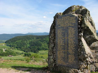
Basse-sur-le-Rupt is a commune in the Vosges department in Grand Est in northeastern France. Its inhabitants are called Bassurois. It is a mountainous commune of seven hamlets, crossed by the river Rupt. Its landmarks include Le Haut du Roc, Le Pierre des Communes, Le Piquante Pierre and the memorial of Le Croix des Moinats. Its historical industries were textiles, sawmills and granite.

The Vologne is a river of the Vosges department in France. It is a right tributary of the Moselle. Its source is in the Vosges Mountains, on the northwestern slope of the Hohneck. It flows through the lakes of Retournemer and Longemer, and passes the villages of Xonrupt-Longemer, Granges-sur-Vologne, Lépanges-sur-Vologne and Docelles, finally flowing into the Moselle in Pouxeux.
The Orbe is a river of the Rhine basin. It starts in France and flows to Switzerland where it forms the river Thielle at its confluence with the river Talent. Not to be mistaken with the Orbe, which is a tributary of the Arrats.
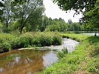
The Neuné is a river which flows in the Vosges department of France. It is a right tributary of the Vologne, and therefore a sub-tributary of the Moselle. It is 24.5 km (15.2 mi) long.

The Cleurie or rupt de Cleurie is a river in Lorraine in France, which flows in the Vosges department. It is a right tributary of the Moselotte, and thus a sub-tributary of the Rhine, via the Moselotte and the Moselle. It is 18.9 km (11.7 mi) long.

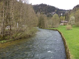
The Moselotte is a river in Lorraine, in the French department of Vosges. It is a direct right tributary of the Moselle, and thus a sub-tributary of the Rhine.

The Xoulces is a small but abundant river in France which flows in Lorraine in the Vosges department. It is a left tributary of the Moselotte, and thus a sub-tributary of the Rhine via the Moselotte and the Moselle. It is 9.4 km (5.8 mi) long.
The Lanterne is a river in the east of France, a substantial left tributary of the Saône, and sub-tributary of the Rhône. It is 64.3 km (40.0 mi) long.

The Apance is a river in the East of France. It is one of the main tributaries to the Upper Saône from the Grand Est region. It is 34.4 km (21.4 mi) long.
The Aulnois is a Franco-Belgian river which flows in the French Ardennes département and in the province of Luxembourg in the far south of Belgian Wallonia. It is about 18 km (11 mi) long, of which 7 km in France. It is a fairly fast-flowing right tributary of the Chiers.

The Fave is a river in France in the eastern region of Lorraine. It flows in the Vosges département. It is a tributary of the Meurthe, thus a sub-tributary of the Moselle and of the Rhine. It is 22.2 km (13.8 mi) long.
The Gier is a French river that flows in a northeast direction through the Loire and Rhône departments. It is a tributary of the Rhône, which it enters from the right bank. The Gier valley was formerly heavily industrialized with coal and iron mines and factories.
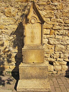
The Fensch or Fentsch is a river in the Moselle department of the Grand Est region of France. It is a left tributary of the Moselle, and thus a sub-tributary of the Rhine.

The Erco is a stream in the department of Haute-Corse, Corsica, France. It is a tributary of the Golo.


