
Ballycastle is a small seaside town in County Antrim, Northern Ireland. It is on the north-easternmost coastal tip of Ireland, in the Antrim Coast and Glens Area of Outstanding Natural Beauty. The harbour hosts the ferry to Rathlin Island, which can be seen from the coast. The Ould Lammas Fair is held each year in Ballycastle on the last Monday and Tuesday of August. Ballycastle is the home of the Corrymeela Community.
Carrick Rangers Football Club is a semi-professional Northern Irish football club playing in NIFL Premiership. The club, founded in 1939, hails from Carrickfergus, County Antrim and plays its home matches at Taylors Avenue which is known as the Belfast Loughshore Hotel Arena due to sponsorship reasons. Carrick Rangers main rivals are Larne, with matches between the sides being known as, "The East Antrim Derby." Ballyclare Comrades are also local rivals.

Ballymena is a town in County Antrim, Northern Ireland. It is part of the Borough of Mid and East Antrim.
Larne Borough Council was a Local Council in County Antrim in Northern Ireland. It merged with Ballymena Borough Council and Carrickfergus Borough Council in May 2015 under the reorganisation of local government in Northern Ireland to become Mid and East Antrim Borough Council.

The Six Mile Water is a river in southern County Antrim, Northern Ireland. It is an indirect tributary of the River Bann, via Lough Neagh.

Portglenone is a village and civil parish in County Antrim, Northern Ireland. It lies 8.5 miles (14 km) west of Ballymena. It had a population of 1,174 people in the 2011 Census. Portglenone is beside the smaller village of Glenone, from which it is separated by the River Bann.
Cullybackey or Cullybacky is a large village in County Antrim, Northern Ireland. It lies 3 miles north-west of Ballymena, on the banks of the River Main, and is part of Mid and East Antrim district. It had a population of 2,569 people in the 2011 Census.
Cloughmills or Cloghmills is a village in County Antrim, Northern Ireland. Ballymoney is 9 miles to the north-west and Ballymena is 10 miles to the south. It had a population of 1,309 people in the 2011 Census. It is in Causeway Coast and Glens District Council.

Cargan is a hamlet and townland in County Antrim, Northern Ireland. It lies at the foot of Slievenanee in Glenravel – locally known as "The Tenth Glen" along with the more widely known nine Glens of Antrim. It is part of Mid and East Antrim district. It had a population of 588 people in the 2011 Census.
Martinstown is a small village in County Antrim, Northern Ireland. Located 6 miles from Ballymena, it is situated in Glenravel, locally known as "The Tenth Glen", alongside the widely known nine Glens of Antrim.

The Kells Water is a small river in County Antrim, Northern Ireland. It flows through Moorfields and Kells and is a tributary to the River Main. The river rises above Glenwherry. It is a continuation of the Glenwhirry River and eventually joins the Main, which in turn flows into Lough Neagh. The hamlet of Kellswater is nearby. An old stone bridge crosses the Kells Water, separating Kells from the adjacent village of Connor.

The A26 is a road in Northern Ireland. It travels in a north–south direction from Coleraine, County Londonderry to Banbridge, County Down.

Mid Antrim was a constituency of the Northern Ireland House of Commons.
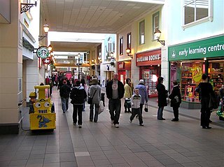
The Fairhill Centre is a shopping centre located in Ballymena, County Antrim, Northern Ireland. It contains over 50 stores and a food court and has parking for over 1,100 cars in a multi-storey car park. It is open seven days a week. Anchor tenants include Next, New Look and Marks & Spencer. In 2007 Debenhams opened its first Desire fashion store in Ireland at the Centre.

Randalstown is a townland and small town in County Antrim, Northern Ireland, between Antrim and Toome. It has a very prominent disused railway viaduct and lies beside Lough Neagh and the Shane's Castle estate. The town is bypassed by the M22 motorway with junctions at both the eastern and western ends of the town. It had a population of 5,126 people in the 2011 Census.

The Blackstaff River is a watercourse in County Antrim, Northern Ireland. It rises on the eastern slope of the Black Mountain before flowing down into the Bog Meadows and passing under the city of Belfast, where it enters the River Lagan. Much of its course has been culverted and built upon since the 19th century, making it largely invisible today. Its tributaries include the Forth or Clowney River, which meets it beneath the Broadway Roundabout in West Belfast.

Mid and East Antrim is a local government district in Northern Ireland. The district was created on 1 April 2015 by merging the Borough of Ballymena, the Borough of Larne and the Borough of Carrickfergus. The local authority is Mid and East Antrim Borough Council.
The River Main or Maine is a river in Northern Ireland, flowing through County Antrim.
The Springmount Bog Tablets are a set of six wooden wax tablets dating to the late 7th or early 8th century that were discovered in 1914 in the Springmount bog near Ballyhutherland, County Antrim, Northern Ireland. The tablets form a booklet with text from the Book of Psalms inscribed on the wax surface of the wooden pages. The tablets are considered to be the earliest surviving example of Irish writing in the Latin script, and were included as no. 25 in a set of 100 items representing A History of Ireland in 100 Objects compiled by The Irish Times, the National Museum of Ireland, and the Royal Irish Academy.

William James Knowles was an Irish amateur archaeologist.
