
Armagh is the county town of County Armagh and a city in Northern Ireland, as well as a civil parish. It is the ecclesiastical capital of Ireland – the seat of the Archbishops of Armagh, the Primates of All Ireland for both the Roman Catholic Church and the Church of Ireland. In ancient times, nearby Navan Fort was a pagan ceremonial site and one of the great royal capitals of Gaelic Ireland. Today, Armagh is home to two cathedrals and the Armagh Observatory, and is known for its Georgian architecture.
Benburb ) is a village and townland in County Tyrone, Northern Ireland. It lies 7.5 miles from Armagh and 8 miles from Dungannon. The River Blackwater runs alongside the village as does the Ulster Canal.
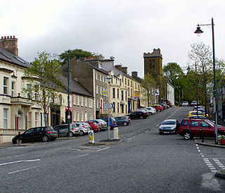
Richhill is a large village and townland in County Armagh, Northern Ireland. It lies between Armagh and Portadown. It had a population of 2,821 people in the 2011 Census.

Tynan is a village, townland and civil parish in County Armagh, Northern Ireland. It is situated largely in the historic barony of Tiranny, with some areas in the barony of Armagh, around 11 kilometres (7 mi) west of Armagh City.

Acton is a hamlet and townland of 22 acres in County Armagh, Northern Ireland, about a half mile north of Poyntzpass. It is situated in the civil parish of Ballymore and the historic barony of Orior Lower and within the Armagh City, Banbridge and Craigavon Borough Council area. It had a population of 72 people in the 2011 Census.
Mountnorris is a small village and townland in County Armagh, Northern Ireland. The village also extends into the townland of Tullyherron. It lies about six miles south of Markethill. It is within the Armagh, Banbridge and Craigavon local government area. It had a population of 155 people in the 2011 Census.
Tartaraghan is a small village and civil parish in County Armagh, Northern Ireland. In the 2001 Census it had a population of 90 people. It is within Craigavon Borough Council area. Tartaraghan is also the name of the parish of which the village is part. The name was formerly spelt Taghterraghan and is thought to come from Irish: Teach Tíreacháin, meaning 'Tíreachán's house'. However, the origin Tart Aracháin has also been put forth.

Caledon is a small village and townland in County Tyrone, Northern Ireland. It is in the Clogher Valley on the banks of the River Blackwater, 10 km from Armagh. It lies in the southeast of Tyrone and near the borders of County Armagh and County Monaghan. It is situated in the historic barony of Dungannon Lower and the civil parish of Aghaloo. In the 2001 Census it had a population of 387 people. It is a designated conservation area. It was historically known as Kinnaird (Irish: Cionn Aird, meaning "head/top of the height or hill".
Ballydugan or Ballydougan is a townland in County Armagh, Northern Ireland. It lies on the County Armagh–County Down border, between Lurgan and Gilford. Ballydougan is within the Armagh City, Banbridge and Craigavon Borough Council area.

Derrynoose is a village and civil parish in south County Armagh, Northern Ireland, 4.5 km south-west of Keady.
Creeveroe is a townland in County Armagh, Northern Ireland. It is about three-and-a-half miles west of Armagh, and is situated within the civil parish of Eglish. The townland derives its name from the Irish an Chraobh Rua, referring to the Red Branch, one of the three royal houses of Conchobar mac Nessa, legendary king of the Ulaid, at nearby Navan Fort.
Killeen or Killean is a small village and townland in the civil parish of Killeavy, County Armagh, Northern Ireland. It lies about four miles (6.5 km) south of Newry, near the border with County Louth in the Republic of Ireland.

Aughanduff is a small village and townland in the civil parish of Forkhill, in the former barony of Orior Upper, and County of Armagh, Northern Ireland. The townland is roughly co-existent with Upper and Lower Aughanduff Mountains, both of which form part of the Ring of Gullion geological formation, which has been described as the most spectacular example of a ring-dyke intrusion in the British Isles, and was the first ring dyke in the world to be geologically mapped. Aughanduff has been populated since prehistoric times and has been recorded as a distinct district since at least the early 1600s. The area's history is both well documented and reflects its location both in rural Ireland and on the borderlands of the Pale, the Plantation of Ulster, and latterly Northern Ireland; indeed, part of the district's northern boundary was proposed for forming part of the northern border of the Irish Free State by the Irish Boundary Commission in its final report of 1925. The Boundary Commission's report was never implemented and today, the area remains within Northern Ireland, some five miles from the border with the Republic of Ireland. Part of the area has been designated by the Northern Ireland Environment Agency as an Area of Special Scientific Interest, and the district lies within the Ring of Gullion Area of Outstanding Natural Beauty.
Ballynagarrick is a townland situated outside Craigavon, County Armagh, Northern Ireland. The literal translation of the name means town (land) of the rocks, and indeed in bygone days two quarries were situated on the small townland.
Derrycrew is a townland of 444 acres in County Armagh, Northern Ireland. It is situated in the civil parish of Loughgall and the historic barony of Oneilland West.

Oneilland West is a barony in County Armagh, Northern Ireland. It is also called Clancann, after the Mac Cana clan. It lies in the north of the county on the south-western shore of Lough Neagh and the border of County Tyrone. Oneilland West is bordered by five other baronies: Armagh to the west; Dungannon Middle to the north-west; Oneilland East to the north-east; Orior Lower to the south-east; and Kinelarty to the south.

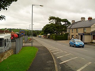
Poyntzpass is a small village on the border between southern County Armagh and County Down in Northern Ireland. It is situated in the civil parish of Ballymore and the historic barony of Orior Lower within the Armagh City, Banbridge and Craigavon area. It had a population of 552 people in the 2011 Census. It was a part of the South Armagh constituency and is now part of the Newry and Armagh constituency.
Ballymore is a civil parish and townland in County Armagh, Northern Ireland. It is situated in the historic barony of Orior Lower.
