Related Research Articles

Keady is a village and civil parish in County Armagh, Northern Ireland. It is south of Armagh and near the border with the Republic of Ireland. It is situated mainly in the historic barony of Armagh with six townlands in the barony of Tiranny. It had a population of 3,051 people in the 2011 Census.
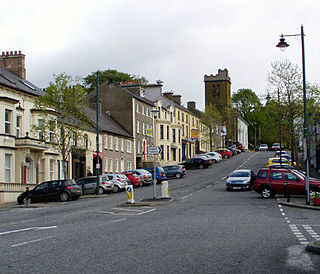
Richhill is a large village and townland in County Armagh, Northern Ireland. It lies between Armagh and Portadown. It had a population of 2,738 people in the 2021 Census.

Middletown is a small village and townland in County Armagh, Northern Ireland. It lies near the border with County Monaghan, between Armagh and Monaghan along the A3. It had a population of 237 people in the 2011 Census.

Acton is a hamlet and townland of 22 acres in County Armagh, Northern Ireland, about a half mile north of Poyntzpass. It is situated in the civil parish of Ballymore and the historic barony of Orior Lower and within the Armagh City, Banbridge and Craigavon Borough Council area. It had a population of 72 people in the 2011 Census.
Tartaraghan is a small village and civil parish in County Armagh, Northern Ireland. In the 2001 Census it had a population of 90 people. It is within Craigavon Borough Council area. Tartaraghan is also the name of the parish of which the village is part. The name was formerly spelt Taghterraghan and is thought to come from Irish Teach Tíreacháin, meaning 'Tíreachán's house'. However, the origin Tart Aracháin has also been put forth.

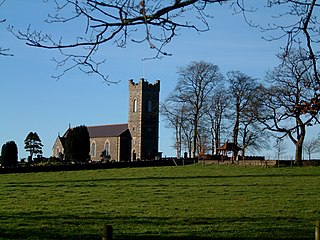
Caledon is a small village and townland in County Tyrone, Northern Ireland. It is in the Clogher Valley on the banks of the River Blackwater, 10 km from Armagh. It lies in the southeast of Tyrone and near the borders of County Armagh and County Monaghan. It is situated in the historic barony of Dungannon Lower and the civil parish of Aghaloo. In the 2001 Census it had a population of 387 people. It is a designated conservation area. It was historically known as Kinnaird.

Derrynoose is a village and civil parish in south County Armagh, Northern Ireland, 4.5 km south-west of Keady.

Killyman is a small village and a civil parish in Northern Ireland, situated on the eastern boundary of County Tyrone and extending into County Armagh. The majority of townlands are in the historic barony of Dungannon Middle in County Tyrone, the rest being in the barony of Oneilland West in County Armagh.

Granemore is a townland of 785 acres in County Armagh, Northern Ireland, about seven miles from Armagh and three miles from Keady. It is situated in the civil parish of Keady and historic barony of Armagh.
Derrycrew is a townland of 444 acres in County Armagh, Northern Ireland. It is situated in the civil parish of Loughgall and the historic barony of Oneilland West.

Poyntzpass is a small village on the border between southern County Armagh and County Down in Northern Ireland. It is situated in the civil parish of Ballymore and the historic barony of Orior Lower within the Armagh City, Banbridge and Craigavon area. It had a population of 552 people in the 2011 census. It was a part of the South Armagh constituency and is now part of the Newry and Armagh constituency.
Monclone is a townland of 245 acres in County Armagh, Northern Ireland. It is situated in the civil parish of Ballymore and the historic barony of Orior Lower.
Shaneglish is a townland of 239 acres in County Armagh, Northern Ireland. It is situated in the civil parish of Ballymore and the historic barony of Orior Lower.
Tullylinn is a townland of 189 acres in County Armagh, Northern Ireland. It is situated in the civil parish of Ballymore and the historic barony of Orior Lower.
Lisnagree is a townland of 241 acres in County Armagh, Northern Ireland. It is situated in the civil parish of Ballymore and the historic barony of Orior Lower.
Druminargal is a townland of 389 acres in County Armagh, Northern Ireland. It is situated in the civil parish of Ballymore and the historic barony of Orior Lower, near Poyntzpass.
Tannyoky is a townland of 181 acres in County Armagh, Northern Ireland. It is situated in the civil parish of Ballymore and the historic barony of Orior Lower.
Carrickbrack is a townland of 213 acres in County Armagh, Northern Ireland. It is situated in the civil parish of Ballymore and the historic barony of Orior Lower.
Brannock is a townland in Poyntzpass, County Armagh. It comes from the Irish name Bran Cnoc which translates as Hill of the Raven. It is situated in the Barony of Orior Lower and the Parish of Ballymore. A number of well-known local families and people were from, or lived in, Brannock such as MacCulla, Calvert, McComb, McGivern, Morrow, Alexander and Mackle.
References
- ↑ "Federnagh". Place Names NI. Archived from the original on 18 May 2015. Retrieved 14 May 2015.
- ↑ "Federnagh". IreAtlas Townlands Database. Retrieved 14 May 2015.

| | This article related to the geography of County Armagh, Northern Ireland is a stub. You can help Wikipedia by expanding it. |