Brassiere Hills

Last updated
Brassiere Hills
Highest point
Elevation 2,333 ft (711 m)
Coordinates 58°27′38″N134°02′44″W / 58.46056°N 134.04556°W / 58.46056; -134.04556 Coordinates: 58°27′38″N134°02′44″W / 58.46056°N 134.04556°W / 58.46056; -134.04556
Geography
Location Juneau, Alaska, United States
Parent range Juneau Icefield / Boundary Ranges
Topo map USGS Juneau B-1

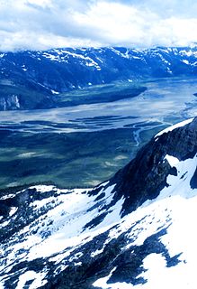
The Brassiere Hills are a pair of summits in the City and Borough of Juneau, Alaska, United States. It is located at the northern end of Taku Inlet, 4.5 miles (7.2 km) north of Taku Point and 18 miles (29 km) northeast of the city of Juneau. The peaks are 2,405 feet (733 m) and 2,360 feet (719 m) high and a stream named Zipper Creek runs between them. [1]

Juneau, Alaska State capital city and borough in Alaska, United States

The City and Borough of Juneau, commonly known as Juneau, is the capital city of Alaska. It is a unified municipality on Gastineau Channel in the Alaskan panhandle, and it is the second largest city in the United States by area. Juneau has been the capital of Alaska since 1906, when the government of what was the District of Alaska was moved from Sitka as dictated by the U.S. Congress in 1900. The municipality unified on July 1, 1970, when the city of Juneau merged with the city of Douglas and the surrounding Greater Juneau Borough to form the current municipality, which is larger by area than both Rhode Island and Delaware.

Alaska State of the United States of America

Alaska is a U.S. state in the northwest extremity of North America, just across the Bering Strait from Asia. The Canadian province of British Columbia and territory of Yukon border the state to the east, its most extreme western part is Attu Island, and it has a maritime border with Russia to the west across the Bering Strait. To the north are the Chukchi and Beaufort seas—southern parts of the Arctic Ocean. The Pacific Ocean lies to the south and southwest. It is the largest U.S. state by area and the seventh largest subnational division in the world. In addition, it is the 3rd least populous and the most sparsely populated of the 50 United States; nevertheless, it is by far the most populous territory located mostly north of the 60th parallel in North America: its population—estimated at 738,432 by the United States Census Bureau in 2015— is more than quadruple the combined populations of Northern Canada and Greenland. Approximately half of Alaska's residents live within the Anchorage metropolitan area. Alaska's economy is dominated by the fishing, natural gas, and oil industries, resources which it has in abundance. Military bases and tourism are also a significant part of the economy.

Taku Inlet

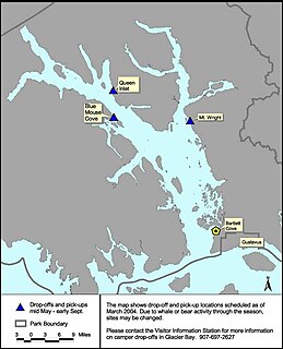
Taku Inlet is an inlet located in the U.S. state of Alaska. It extends 18 miles (29 km) in a northeast direction from Stephens Passage in the Alexander Archipelago, about 12 kilometres (7.5 mi) southeast of Juneau, widening to a basin where discharge from the Taku River and Taku Glacier emerges.

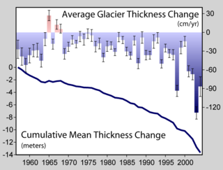
Ice thickness studies of Taku Glacier were conducted near the hills in 1989, 1990, and 1993. [2]

Taku Glacier glacier in the United States

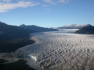
Taku Glacier is a tidewater glacier located in Taku Inlet in the U.S. state of Alaska, just southeast of the city of Juneau. Recognized as the deepest and thickest alpine temperate glacier known in the world, the Taku Glacier is measured at 4,845 feet (1,477 m) thick. It is about 58 kilometres (36 mi) long, and is largely within the Tongass National Forest.

Nancy Bartley of The Seattle Times attributes the naming to photographer Austin Post. [3]

<i>The Seattle Times</i> newspaper

The Seattle Times is a daily newspaper serving Seattle, Washington, United States. It has the largest circulation of any newspaper in the state of Washington and in the Pacific Northwest region.

Austin Post American photographer

Austin S. Post was a photographer, glaciologist, and mountaineer known for his aerial photography of the mountains and glaciers of North America, particularly the North Cascades of Washington and Glacier Bay, Alaska.

The name was noted by the United States Geological Survey on 1948 and 1962 topographical maps of the Juneau area, but it was removed prior to the latter edition's publication. It later appeared on a 1997 USGS map. [4] It was entered into the Geographic Names Information System on March 31, 1981. [5]

United States Geological Survey scientific agency of the United States government

The United States Geological Survey is a scientific agency of the United States government. The scientists of the USGS study the landscape of the United States, its natural resources, and the natural hazards that threaten it. The organization has four major science disciplines, concerning biology, geography, geology, and hydrology. The USGS is a fact-finding research organization with no regulatory responsibility.

Geographic Names Information System geographical database

The Geographic Names Information System (GNIS) is a database that contains name and locative information about more than two million physical and cultural features located throughout the United States of America and its territories. It is a type of gazetteer. GNIS was developed by the United States Geological Survey in cooperation with the United States Board on Geographic Names (BGN) to promote the standardization of feature names.

Related Research Articles

Glacier Bay Basin bay in Alaska with its surrounding mountains and glaciers

Glacier Bay Basin in southeastern Alaska, in the United States, encompasses the Glacier Bay and surrounding mountains and glaciers, which was first proclaimed a U.S. National Monument on February 25, 1925, and which was later, on December 2, 1980, enlarged and designated as the Glacier Bay National Park and Preserve under the Alaska National Interest Lands Conservation Act, covering an area of 3,283,000 acres. In 1986, UNESCO declared an area of 57,000 acres within a World Biosphere Reserve. This is the largest UNESCO protected biosphere in the world. In 1992, UNESCO included this area as a part of a World Heritage site, extending over an area of 24,300,000-acre (98,000 km2) which also included the Wrangell-St. Elias National Park, Kluane National Park (Canada) and Tatshenshini-Alsek Park (Canada). Part of the National Park is also designated a Wilderness area covering 2,658,000 acres.

Mount Sanford (Alaska) mountain

Mount Sanford is a shield volcano in the Wrangell Volcanic Field, in eastern Alaska near the Copper River. It is the sixth highest mountain in the United States and the third highest volcano behind Mount Bona and Mount Blackburn. The south face of the volcano, at the head of the Sanford Glacier, rises 8,000 feet (2,400 m) in 1 mile (1,600 m) resulting in one of the steepest gradients in North America.

Taku River

The Taku River is a river running from British Columbia, Canada, to the northwestern coast of North America, at Juneau, Alaska. The river basin spreads across 27,500 square kilometres (10,600 sq mi). The Taku is a very productive salmon river and its drainage basin is primarily wilderness.

Juneau International Airport

Juneau International Airport is a city-owned, public-use airport and seaplane base located seven nautical miles northwest of the central business district of Juneau, a city and borough in the U.S. state of Alaska that has no direct road access to the outside world. The airport serves as a regional hub for all air travel, from bush carriers to a major U.S. air carrier, Alaska Airlines.

MV <i>Taku</i>

M/V Taku is a Malaspina-class mainline vessel built for the Alaska Marine Highway System. The ship has been retired and was sold to a Dubai-based company for $171,000. The owner sought to sell the ferry internationally, and was unsuccessful, and it was last seen beached in Alang, India, to be scrapped.

Juneau Icefield glacier in Canada

The Juneau Icefield is an ice field located just north of Juneau, Alaska, continuing north through the border with British Columbia, extending through an area of 3,900 square kilometres (1,500 sq mi) in the Coast Range ranging 140 km (87 mi) north to south and 75 km (47 mi) east to west. The icefield is the source of many glaciers including the Mendenhall Glacier and the Taku Glacier. The icefield is home to over 40 large valley glaciers and 100 smaller ones. The Icefield serves as a tourist attraction with many travellers flown in by helicopter for quick walks on the 240-to-1,400-metre deep ice and the massive, awe-inspiring moist crevasses. The icefield, like many of its glaciers, reached its maximum glaciation point around 1700 and has been in retreat since. In fact, of the icefield's 19 notable glaciers, the Taku Glacier is the only one presently advancing. Much of the icefield is contained within the Tongass National Forest. Since 1948, the Juneau Icefield Research Program has monitored glaciers of the Juneau Icefield. On the west side of the icefield, from 1946-2009, the terminus of the Mendenhall Glacier has retreated over 700 metres (0.43 mi).

Glacier mass balance

Crucial to the survival of a glacier is its mass balance or surface mass balance (SMB), the difference between accumulation and ablation. Climate change may cause variations in both temperature and snowfall, causing changes in the surface mass balance. Changes in mass balance control a glacier's long-term behavior and are the most sensitive climate indicators on a glacier. From 1980–2012 the mean cumulative mass loss of glaciers reporting mass balance to the World Glacier Monitoring Service is −16 m. This includes 23 consecutive years of negative mass balances.

Stikine Icecap glacier in Canada

The Stikine Icecap is a large icefield straddled on the Alaska–British Columbia boundary in the Alaska Panhandle region. It lies in the Boundary Ranges of the Coast Mountains. Within the United States, most of it is under the administration of the Tongass National Forest and is part of the Stikine-LeConte Wilderness within the national forest.

Tidewater glacier cycle

The tidewater glacier cycle is the typically centuries-long behavior of tidewater glaciers that consists of recurring periods of advance alternating with rapid retreat and punctuated by periods of stability. During portions of its cycle, a tidewater glacier is relatively insensitive to climate change.

Amherst Peak is a mountain in the city and borough of Juneau, Alaska, United States. It is a part of the Boundary Ranges of the Coast Mountains in western North America. It is near the Taku Glacier, 0.2 miles (0.32 km) northwest of Echo Pass and 14 miles (23 km) north of the city of Juneau.

Table Top Mountain is a mountain in the city and borough of Juneau, Alaska, United States. It is a peak of the Boundary Ranges, located on Douglas Island 2 miles (3.2 km) northeast of Cropley Lake and 3.5 miles (5.6 km) west of the city of Juneau.

Elevenmile Creek is a river on Douglas Island in the City and Borough of Juneau (CBJ), Alaska, United States. Its origin is in hills to the southeast and it flows northwest to Fritz Cove, a part of Stephens Passage; it is 1.6 miles (2.6 km) southwest of Entrance Point and 8.6 miles (13.8 km) west of the city of Juneau.

Zipper Creek is a river in the City and Borough of Juneau, Alaska, United States. Located 19 miles (31 km) northeast of the city of Juneau, its origin is in the Brassiere Hills. It flows southward past Taku Glacier and ends at the head of Taku Inlet.

Camp 15 Peak is a mountain in the borough of Juneau, Alaska, United States. It is part of the Boundary Ranges of the Coast Mountains in western North America. On the divide east of Battle Glacier, it is located 3 miles southwest of The Tusk and 28 miles north-northwest of the city of Juneau.

Gulkana Glacier

Gulkana Glacier is a glacier that flows from the ice fields of the south flank of the eastern Alaska Range. It is accessible by gravel roads from the Richardson Highway near mile post 197 at the Richardson Monument, just two miles north of Summit Lake and 12 miles north of Paxson and the junction with Denali Highway. Closer to the glacier, a suspension bridge allows pedestrians to cross over Phelan Creek. Wildlife includes moose and bears. The peak of a hill just southwest of Gulkana Glacier has a post labeled PEWE 1975. The Arctic Man competition takes place near Gulkana Glacier every spring.

Twin Glacier Camp

The Twin Glacier Camp, also known as the Twin Glacier Lodge and now Taku Glacier Lodge, is a historic wilderness recreation complex in Juneau Borough, Alaska. It is located on the southern banks of the Taku River, about 30 miles (48 km) from the city of Juneau. The camp consists of thirteen buildings on 12 acres (4.9 ha), about half of which were built in the first ten years of the camp's existence. The main lodge house is a log and stone structure measuring 40 by 20 feet. It is one of the few surviving camps established in Alaska during the 1920s.

References

  1. Monmonier, Mark. ""Get these inflammatory toponyms before they're gone"" (PDF). (150.75 KB) 2006. Accessed June 9, 2010.
  2. Nolan, et al. ""Ice-thickness measurements of Taku Glacier, Alaska, U.S.A., and their relevance to its recent behavior"" (PDF). (2.12 MB)Journal of Glaciology. 1995. Accessed June 9, 2010.
  3. Bartley, Nancy (July 21, 2004). "Vashon Island scientist's lifelong love affair with glaciers". The Seattle Times. The Seattle Times Company. Retrieved June 9, 2010.
  4. Monmonier, Mark S. From Squaw Tit to Whorehouse Meadow: How Maps Name, Claim, and Inflame. 2006.
  5. USGS GNIS Feature Detail Report: Brassiere Hills