Related Research Articles
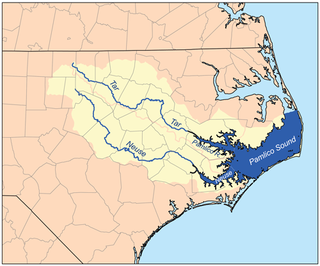
The PamlicoRiver is a tidal river that flows into Pamlico Sound, in North Carolina in the United States. It is formed by the confluence of the Tar River and Tranters Creek.

New Kent is a census-designated place (CDP) in and the county seat of New Kent County, Virginia, United States. The population as of the 2010 Census was 239.
Currioman Landing is an unincorporated community in Westmoreland County, in the U. S. state of Virginia.
Hinnom is an unincorporated community in Westmoreland County, in the Commonwealth of Virginia. It lies about five miles from Montross, Virginia, at the end of Zacata Road, and consists of the region south of Nomini Bay and west of Nomini Creek. It no longer has a Post Office or a ferry landing.
Leedstown is an unincorporated community in Westmoreland County, in the U. S. state of Virginia. It is the site of the signing of the Leedstown Resolutions.

Greyhound Rock State Marine Conservation Area (SMCA) is one of two adjoining marine protected areas off the coast of San Mateo County and Santa Cruz County, on California’s central coast. The area is approximately 55 miles (89 km) south of San Francisco. The SMCA is 11.81 square miles (30.6 km2). Within the SMCA fishing and take of all living marine resources is prohibited except the recreational take of giant kelp, squid, salmon, and other finfish, subject to various conditions. Also permitted is the commercial take of giant kelp, salmon, and squid, subject to various conditions.
Highland Landing is an unincorporated community in Northumberland County, in the U.S. state of Virginia.
Lara is an unincorporated community in Northumberland and Richmond counties, in the U.S. state of Virginia.
Luttrellville is an unincorporated community in Northumberland and Richmond counties, in the U.S. state of Virginia.
Mila is an unincorporated community in Northumberland County, in the U.S. state of Virginia. Mila is located at 37°50′32″N76°19′39″W.
Rainswood is an unincorporated community in Northumberland and Richmond counties, in the U.S. state of Virginia.
Walkers Corner is an unincorporated community in Northumberland and Richmond counties, in the U.S. state of Virginia.
Oakley Landing is an unincorporated community in Richmond County, in the U.S. state of Virginia. It is located eight miles south of Farnham at the southern tip of Hales Point, close to Tarpley Point, on the Rappahannock river.
Ryan is a populated place in Roane County, West Virginia, United States. The name was collected by the United States Geological Survey between 1976 and 1980, and entered into the Geographic Names Information System on June 27, 1980.
Scotts Fork is an unincorporated community located in Amelia County, in the U.S. state of Virginia.
Fleeburg is an unincorporated community in Page County, in the U.S. state of Virginia.
Miller Creek is a stream in the U.S. state of West Virginia. It is a tributary of Tug Fork.
Sweetwater Creek is a stream in western Reynolds and northeastern Shannon counties of the Ozarks of southern Missouri. It is a tributary of the Logan Creek.
Forkners Hill is an unincorporated community in northern Webster County, in the Ozarks of southern Missouri. The community is situated at the intersection of routes WW and Y, north of the Niangua River, at an elevation of 1250 feet. Conway is four miles to the northeast, in Laclede County.
References

Coordinates: 37°19′06″N76°28′22″W / 37.31833°N 76.47278°W
| This Gloucester County, Virginia state location article is a stub. You can help Wikipedia by expanding it. |