Brecljevo

Last updated
Brecljevo
Sveti Tomaž pri Šmarju (until 1955)
Slovenia location map.svg
Red pog.svg
Brecljevo
Location in Slovenia
Coordinates: 46°13′11.67″N15°31′55.56″E / 46.2199083°N 15.5321000°E / 46.2199083; 15.5321000 Coordinates: 46°13′11.67″N15°31′55.56″E / 46.2199083°N 15.5321000°E / 46.2199083; 15.5321000
Country Flag of Slovenia.svg Slovenia
Traditional region Styria
Statistical region Savinja
Municipality Šmarje pri Jelšah
Area
  Total 1.23 km2 (0.47 sq mi)
Elevation 297.5 m (976.0 ft)
Population (2002)
  Total 167
[1]

Brecljevo (pronounced  [ˈbɾeːtsljɛʋɔ] ) is a settlement in the Municipality of Šmarje pri Jelšah in eastern Slovenia. It lies in the hills south of Šmarje. The area was traditionally part of Styria. The municipality is now included in the Savinja Statistical Region. [2]

Municipality An administrative division having corporate status and usually some powers of self-government or jurisdiction

A municipality is usually a single administrative division having corporate status and powers of self-government or jurisdiction as granted by national and regional laws to which it is subordinate. It is to be distinguished (usually) from the county, which may encompass rural territory or numerous small communities such as towns, villages and hamlets.

Šmarje pri Jelšah Town and Municipality in Slovenia

Šmarje pri Jelšah is a town and a municipality in eastern Slovenia. The area was part of the traditional region of Styria. The municipality is now included in the Savinja Statistical Region. The development of the settlement is associated with a medieval mansion known as Jelšingrad on a slight hill northwest of the town.

Slovenia republic in Central Europe

Slovenia, officially the Republic of Slovenia, is a sovereign state located in southern Central Europe at a crossroads of important European cultural and trade routes. It is bordered by Italy to the west, Austria to the north, Hungary to the northeast, Croatia to the southeast, and the Adriatic Sea to the southwest. It covers 20,273 square kilometers (7,827 sq mi) and has a population of 2.07 million. One of the successor states of the former Yugoslavia, Slovenia is a parliamentary republic and a member of the United Nations, of the European Union, and of NATO. The capital and largest city is Ljubljana.

Contents

Name

The name of the settlement was changed from Sveti Tomaž pri Šmarju (literally, 'Saint Thomas near Šmarje') to Brecljevo in 1955. The name was changed on the basis of the 1948 Law on Names of Settlements and Designations of Squares, Streets, and Buildings as part of efforts by Slovenia's postwar communist government to remove religious elements from toponyms. [3] [4] [5]

Church

The local church is dedicated to Saint Thomas and belongs to the Parish of Šmarje pri Jelšah. It dates originally to the 15th century but was extensively rebuilt in the 17th and 18th centuries. [6]

Church (building) building constructed for Christian worship

A church building or church house, often simply called a church, is a building used for Christian religious activities, particularly for Christian worship services. The term is often used by Christians to refer to the physical buildings where they worship, but it is sometimes used to refer to buildings of other religions. In traditional Christian architecture, the church is often arranged in the shape of a Christian cross. When viewed from plan view the longest part of a cross is represented by the aisle and the junction of the cross is located at the altar area.

Thomas the Apostle Early Christian, one of the twelve apostles and a saint

Thomas the Apostle (Biblical Hebrew: תומאס הקדוש‎; Greek: Θωμάς; Coptic: ⲑⲱⲙⲁⲥ; Classical Syriac: ܬܐܘܡܐ ܫܠܝܚܐ‎ Ṯaumā s̲h̲liḥā ; also called Didymus which means Twin was one of the Twelve Apostles of Jesus, according to the New Testament.

A parish is a territorial entity in many Christian denominations, constituting a division within a diocese. A parish is under the pastoral care and clerical jurisdiction of a parish priest, who might be assisted by one or more curates, and who operates from a parish church. Historically, a parish often covered the same geographical area as a manor. Its association with the parish church remains paramount.

Related Research Articles

Straža pri Raki in Lower Carniola, Slovenia

Straža pri Raki is a settlement east of Raka in the Municipality of Krško in eastern Slovenia. The area was traditionally part of Lower Carniola. It is now included with the rest of the municipality in the Lower Sava Statistical Region.

Gora pri Pečah Place in Upper Carniola, Slovenia

Gora pri Pečah is a settlement in the Municipality of Moravče in central Slovenia. Traditionally the area was part of Upper Carniola. It is now included with the rest of the municipality in the Central Slovenia Statistical Region.

Lemberg pri Novi Cerkvi in Styria, Slovenia

Lemberg pri Novi Cerkvi is a village in the Municipality of Vojnik in eastern Slovenia. The area was traditionally part of the Styria region. It is now included with the rest of the municipality in the Savinja Statistical Region.

Gorenje pri Zrečah in Styria, Slovenia

Gorenje pri Zrečah is a settlement in the Municipality of Zreče in northeastern Slovenia. The area was traditionally part of the Styria region. It is now included with the rest of the municipality in the Savinja Statistical Region.

Sveti Štefan, Šmarje pri Jelšah in Styria, Slovenia

Sveti Štefan is a small settlement in the Municipality of Šmarje pri Jelšah in eastern Slovenia. It lies in the hills south of Šmarje in the Kozje region. The area is part of the traditional region of Styria. The municipality is now included in the Savinja Statistical Region.

Lemberg pri Šmarju Place in Styria, Slovenia

Lemberg pri Šmarju is a settlement in the Municipality of Šmarje pri Jelšah in eastern Slovenia. It lies in the hills northeast of Šmarje. The area was traditionally part of Styria. The municipality is now included in the Savinja Statistical Region.

Šentvid pri Grobelnem in Styria, Slovenia

Šentvid pri Grobelnem is a village in the Municipality of Šmarje pri Jelšah in eastern Slovenia. It lies on the regional road from Šmarje to Celje. The area was traditionally part of Styria. The municipality is now included in the Savinja Statistical Region.

Vršna Vas in Styria, Slovenia

Vršna Vas is a dispersed settlement in the hills south of Šmarje pri Jelšah in eastern Slovenia. The area is part of Styria and is included in the Savinja Statistical Region. It is a scattered village on a ridge and slope on either side of Zibika Creek. It includes the hamlets of Planinca and Sveta Magdalena.

Vinski Vrh pri Šmarju in Styria, Slovenia

Vinski Vrh pri Šmarju is a small settlement in the Municipality of Šmarje pri Jelšah in eastern Slovenia. It lies in the hills south of Šmarje. The area is part of the historical Styria region. The municipality is now included in the Savinja Statistical Region.

Močle in Styria, Slovenia

Močle is a village in the Municipality of Šmarje pri Jelšah in eastern Slovenia. It lies in the hills west of Šmarje. The area is part of the historical Styria region. The municipality is now included in the Savinja Statistical Region. It is a clustered village on the south side of a gentle slope. It includes the hamlets of Erpoge and Sveti Lovrenc.

Orehovec, Šmarje pri Jelšah in Styria, Slovenia

Orehovec is a settlement in the Municipality of Šmarje pri Jelšah in eastern Slovenia. The area is part of the historical Styria region. The municipality is now included in the Savinja Statistical Region.

Pečica in Styria, Slovenia

Pečica is a settlement in the Municipality of Šmarje pri Jelšah in eastern Slovenia. It lies in the hills north of Sladka Gora. The area is part of the historical Styria region. The municipality is now included in the Savinja Statistical Region.

Sotensko pri Šmarju in Styria, Slovenia

Sotensko pri Šmarju is a settlement in the Municipality of Šmarje pri Jelšah in eastern Slovenia. It lies in the hills north of Šmarje. The area is part of the historical Styria region. The municipality is now included in the Savinja Statistical Region.

Jakob pri Šentjurju in Styria, Slovenia

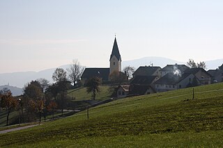
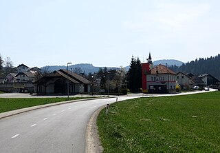
Jakob pri Šentjurju is a settlement south of Šentjur in eastern Slovenia. The area is part of the historical region of Styria. The Municipality of Šentjur is now included in the Savinja Statistical Region.

Šentvid pri Planini Place in Styria, Slovenia

Šentvid pri Planini is a village east of Planina pri Sevnici in the Municipality of Šentjur in eastern Slovenia. The area is part of the historical Styria region. The municipality is now included in the Savinja Statistical Region.

Primož pri Šentjurju in Styria, Slovenia

Primož pri Šentjurju is a settlement in the Municipality of Šentjur in eastern Slovenia. The area is part of the historical Styria region. The municipality is now included in the Savinja Statistical Region. The settlement includes the hamlets of Bozne, Brezne, Grabne, and Kote.

Štefan pri Trebnjem Place in Lower Carniola, Slovenia

Štefan pri Trebnjem is a small village in the Municipality of Trebnje in eastern Slovenia. It lies on the left bank of the Temenica River just west of Trebnje. The area is part of the historical region of Lower Carniola. The municipality is now included in the Southeast Slovenia Statistical Region.

Šent Jurij Place in Lower Carniola, Slovenia

Šent Jurij is a village in the Municipality of Grosuplje in central Slovenia. The area is part of the historical region of Lower Carniola. The municipality is now included in the Central Slovenia Statistical Region.

Šentpavel na Dolenjskem Place in Lower Carniola, Slovenia

Šentpavel na Dolenjskem is a settlement just east of Šentvid pri Stični in the Municipality of Ivančna Gorica in central Slovenia. The area is part of the historical region of Lower Carniola. The municipality is now included in the Central Slovenia Statistical Region. It includes the hamlets of Grumlof, and Mandrga.

Videm pri Ptuju in Styria, Slovenia

Videm pri Ptuju is a settlement in the Municipality of Videm in eastern Slovenia. It is the administrative centre of the municipality. The area traditionally belonged to the Styria region. It is now included in the Drava Statistical Region.

References

  1. Statistical Office of the Republic of Slovenia
  2. Šmarje pri Jelšah municipal site
  3. Spremembe naselij 1948–95. 1996. Database. Ljubljana: Geografski inštitut ZRC SAZU, DZS.
  4. Premk, F. 2004. Slovenska versko-krščanska terminologija v zemljepisnih imenih in spremembe za čas 1921–1967/68. Besedoslovne lastnosti slovenskega jezika: slovenska zemljepisna imena. Ljubljana: Slavistično društvo Slovenije, pp. 113–132.
  5. Urbanc, Mimi, & Matej Gabrovec. 2005. Krajevna imena: poligon za dokazovanje moči in odraz lokalne identitete. Geografski vestnik 77(2): 25–43.
  6. Slovenian Ministry of Culture register of national heritage reference number ešd 3411