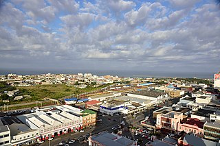
East London is a city on the southeast coast of South Africa in the Buffalo City Metropolitan Municipality of the Eastern Cape province. The city lies on the Indian Ocean coast, largely between the Buffalo River and the Nahoon River, and hosts the country's only river port. As of 2011, East London had a population of over 267,000 with over 755,000 in the metropolitan area.

Bhisho is the capital of the Eastern Cape Province in South Africa. The Office of the Premier, Provincial Legislature and many other government departments are headquartered in the town. The town, three kilometres from King William's Town and 70 kilometres from East London, is also part of Buffalo City.

The Eastern Cape is one of the provinces of South Africa. Its capital is Bhisho, but its two largest cities are East London and Gqeberha.

Knysna is a town with 76,150 inhabitants in the Western Cape province of South Africa. and is one of the destinations on the loosely defined Garden Route tourist route. It lies at 34° 2' 6.3168'' S and 23° 2' 47.2884'' E., and is situated 60 kilometres east of the city of George on the N2 highway, and 33 kilometres west of the Plettenberg Bay on the same road.

Rondebosch is one of the Southern Suburbs of Cape Town, South Africa. It is primarily a residential suburb, with shopping and business districts as well as the main campus of the University of Cape Town.
The following lists events that happened during 1877 in South Africa.

Amatola, Amatole or Amathole are a range of densely forested mountains, situated in the Eastern Cape province of South Africa. The word Amathole means ‘calves’ in Xhosa, and Amathole District Municipality, which lies to the south, is named after these mountains.

Podocarpus henkelii is a South African species of conifer in the family Podocarpaceae. It is grown ornamentally in gardens for its strikingly neat, attractive form and its elegant, drooping foliage.
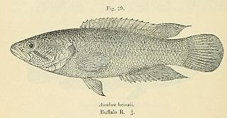
The Eastern Province rocky, also known as rocky kurper, is a species of fish in the family Anabantidae. It is endemic to South Africa.

Colesberg is a town with 17,354 inhabitants in the Northern Cape province of South Africa, located on the main N1 road from Cape Town to Johannesburg.

Grassy Park is a suburb of the City of Cape Town in the Western Cape Province of South Africa.

The Buffalo River is situated in the city of East London on the East Coast of South Africa. It is to the west of the Nahoon River. It is the only navigable river in South Africa. The town of East London was thus established around it.
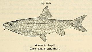
The border barb is a ray-finned fish species in the family Cyprinidae. It is placed with the South African redfins in Pseudobarbus. Like Pseudobarbus. It is tetraploid.

Pacaltsdorp is a suburb of George, Western Cape. In the Apartheid era, it was the coloured township associated with George but administrated independently. The N2 highway provided the natural boundary between the two, enforced by a curfew.

Southern Afrotemperate Forest is a kind of tall, shady, multilayered indigenous South African forest. This is the main forest-type in the south-western part of South Africa, naturally extending from the Cape Peninsula in the west, as far as Port Elizabeth in the east. In this range, it usually occurs in small forest pockets, surrounded by fynbos vegetation.

Kogelberg Nature Reserve is a nature reserve of 3,000 ha comprising the Kogelberg Mountain Range, to the east of Cape Town, South Africa.

Ginsberg is a township on the banks of the Buffalo River that is next to King William's Town, in the Buffalo City Metropolitan Municipality, Eastern Cape, South Africa.
The Tokai Arboretum was the first large-scale silviculture experimental station in Cape Town, South Africa. The area of the main Arboretum, at Tokai Park, is 14 ha. Several adjacent compartments extend the area to 26 ha. The Arboretum was declared a National Monument in 1985, on its 100th anniversary. It contains stands of Eucalyptus and other trees from the original silviculture experiments in South Africa. In the 1990s a Gondwana Garden was created to display the plants typical of the Cape 100 million years ago.

The following outline is provided as an overview of and topical guide to Cape Town:
Tafelsig is a neighbourhood located within the Mitchells Plain urban area of the City of Cape Town in the Western Cape province of South Africa. It is located in the south eastern corner of the Mitchells Plain area.


