
Temburong District, or simply Temburong, is the easternmost district in Brunei. It is an exclave surrounded by Malaysia and the Brunei Bay. Temburong is accessible from Brunei's mainland via the Sultan Haji Omar Ali Saifuddien Bridge. It has a total area of 1,306 km2 (504 sq mi). As of 2016, its population was 10,251; it is the least populous district in Brunei. Bangar is the administrative centre of the Temburong District.

Taliparamba is a Municipality in Taliparamba taluk of Kannur district, Kerala, India. The municipal town spreads over an area of 18.96 square kilometres (7.32 sq mi) and is inhabited by 44,247 number of people.
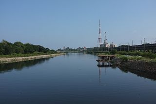
The Cooum River, or simply Koovam, is one of the shortest classified rivers draining into the Bay of Bengal. This river is about 72 km (45 mi) in length, flowing 32 km (20 mi) in the city of Chennai and the rest in rural part. The river is highly polluted in the urban area (Chennai). Along with the Adyar River running parallel to the south and the Kosasthalaiyar River, the river trifurcates the city of Chennai and separates Northern Chennai from Central Chennai. It is also sometimes known as Thiruvallikenni river

Doda district is an administrative district of the Jammu division of Indian-administered Jammu and Kashmir in the disputed Kashmir region.

Tutong is a municipality town in Mukim Pekan Tutong Tutong District, Brunei. It is located about 40 kilometres (25 mi) from the country's capital Bandar Seri Begawan. It is the administrative centre of Tutong District.
Jangaon (Janagama) is a city and the district headquarters of Jangaon district in the Indian state of Telangana. It is also the mandal and divisional headquarters of Jangaon Mandal and Jangaon revenue division respectively. It is about 85 kilometres (53 mi) from the state capital Hyderabad. It lies on the National Highway 163.
Tandlianwala is a town in Punjab, Pakistan and the headquarters of Tandlianwala Tehsil. It is named after a medicinal plant called "Tandla"(digera arvensis) which was present abundantly near this town. It is located 40 km from the city of Faisalabad and 45 km from Okara. It is a sub-division of Faisalabad District and has a Tehsil municipal administration (TMA).

Allenwood is a small Irish village in County Kildare situated on the Grand Canal. Allenwood is located about 47.3 km (29.4 mi) from Dublin and halfway between Rathangan and Clane in north County Kildare. According to the CSO, Allenwood had a total population of 1,685 inhabitants in the 2022 census, an increase 71.8% from the 2016 census. It is one of the fastest growing urban areas in the country.
Shirshi is a village in Kokan on the banks of the Jagbudi River. The village falls under the jurisdiction of the Khed Taluka of Ratnagiri.

Jammu and Kashmir is home to several valleys such as the Kashmir Valley, Chenab Valley, Sindh Valley and Lidder Valley. Some major tourist attractions in Jammu and Kashmir are Srinagar, with its renowned Dal Lake and Mughal Gardens, Gulmarg, Pahalgam, Bhaderwah, Patnitop and Jammu. Every year, thousands of Hindu pilgrims visit holy shrines of Vaishno Devi and Amarnath which has had a significant impact on the state's economy.

Mukim Bangar is a mukim in Temburong District, Brunei. It has a total area of 113 square kilometres (44 sq mi); the population was 2,112 in 2021. The mukim encompasses Bangar, the district's sole town and administrative centre.

Sultan Haji Omar 'Ali Saifuddien Bridge, also known as Temburong Bridge, is a dual-carriageway bridge in Brunei that spans across Brunei Bay, connecting the Bruneian mainland with its semi-exclave of Temburong. It is the longest bridge in Southeast Asia, at 30 kilometres (19 mi) long.

The Chenab Valley is a river valley formed by the Chenab River. The term is also used collectively for Doda, Kishtwar and Ramban districts of Jammu Division in the Indian-administered Jammu and Kashmir. These districts were formerly part of a single district, called Doda.

Thathri is a town and a notified area committee in Doda district in the Indian union territory of Jammu and Kashmir. Thathri valley is located in the foothills of the Himalayan mountains, about 85 km from Batote. Apart from having ample forests, the town contains many small streams flowing through its various parts. It is located on the banks of the Chenab River and the town area is spread over 1.50 sq. Km².
Sabbah Haji is the former Director of Haji Public School, a not-for-profit school established in 2009 by her family in their ancestral village in the Doda district of Jammu and Kashmir, India. Sabbah was born in Dubai in 1982 where her father, Saleem Haji, was a manager in a shipping company. Sabbah's family is from Breswana village of Doda, Jammu and Kashmir. Her family shifted to Dubai in early 1980s and then to Bangalore in 1997. She finally returned to her native village, Breswana, to run the Haji Public School with her family, with the school being the main focus of her life, till she quit in November 2021.
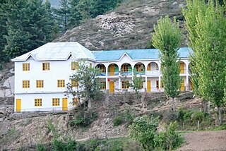
Haji Public School is a non-profit educational institution established in 2009 by the Haji family in Breswana, their ancestral village located in the Doda district of Jammu and Kashmir, Northern India.

The Saint-Cyr River is a tributary of Doda Lake, flowing into the municipality of Eeyou Istchee Baie-James (municipality), in Jamésie, in the area of Nord-du-Québec, Quebec, Canada.
Chinta Valley is a valley and a village located 20 kilometres (12 mi) northeast of Bhaderwah town on Bhaderwah-Jai road. It is covered with thick coniferous forests from all sides with a stream flowing through it known as Chinta Nallah. A village called Thuba divides the valley from Bhaderwah.
Lal Draman is a hill station in Indian union territory of Jammu and Kashmir. It is located at a distance of 25 kilometres (16 mi) north from Doda town near Sazan village, covered with lofty deodar and fir trees. A Grameen-cum-Tourism Mela is organised every year in Lal Draman, depicting the cultural programs of Doda district. Thousand of tourists visits there to enjoy this mela. In 2013, construction of roads started in rural areas including Lal Draman. As of 2020, there is only one 23 kilometres (14 mi) road northwest from Doda town towards Bijarni village and a 3 kilometres (1.9 mi) north by foot from Bijarni to reach the Lal Draman.
Bhal Padri is a hill station situated above a group of small valleys covered with a dense forest located in the Changa, Bhalessa. area of Doda district. It borders Padri Pass, Bhaderwah at a distance of 4 kilometres (2.5 mi) northeast. Rivulets and streams flow through this valley.

