Daggett County is a county in the northeastern corner of the U.S. state of Utah. As of the 2020 United States Census, the population was 935, making it the least populous county in Utah. Its county seat is Manila. The county was named for Ellsworth Daggett, the first surveyor-general of Utah. The small community of Dutch John, located near the state line with Colorado and Wyoming, became an incorporated town in January 2016.

Uintah County is a county in the U.S. state of Utah. As of the 2020 United States Census the population was 35,620. Its county seat and largest city is Vernal. The county was named for the portion of the Ute Indian tribe that lived in the basin.

Bridgeport is an unincorporated community and census-designated place (CDP) in Saginaw County in the U.S. state of Michigan. The CDP had a population of 6,571 at the 2020 census. The community is located within Bridgeport Township.
Brown's Park or Browns Park, originally called Brown's Hole, is an isolated mountain valley along the Green River in Moffat County, Colorado and Daggett County, Utah in the United States. The valley begins in far eastern Utah, approximately 25 miles (40 km) downstream from Flaming Gorge Dam, and follows the river downstream into Colorado, ending at the Gates of Lodore in Dinosaur National Monument. Known as a haven for outlaws such as Butch Cassidy and Tom Horn during the late 19th century and the early 20th century, it is now the location of the Browns Park National Wildlife Refuge. It was also the birthplace of Ann Bassett. She and her sister, Josie Bassett, were considered female outlaws and girlfriends to several of Cassidy's Wild Bunch gang. It is the location of John Jarvie Historic Ranch, where, in 1880, Scotsman John Jarvie built a ranch along the Green River.
Kangley is an unincorporated community in King County, Washington, United States. It is located east of Maple Valley, Washington and north of Kanaskat-Palmer State Park.

This is a directory of properties and districts listed on the National Register of Historic Places in Utah, USA. There are more than 1,800 listed properties in Utah. Each of the 29 counties in Utah has at least two listings on the National Register.

Daggett School District is a public school district in Daggett County, Utah, United States. The district provides education for students living in Daggett County, as well as more than two dozen students from adjacent areas in Wyoming. It is the smallest of the 41 school districts in Utah, with a total of three schools and 181 students.

Dutch John is a town located in eastern Daggett County, Utah, United States, approximately 4 miles (6 km) northeast of the Flaming Gorge Dam on U.S. Route 191. The population was 141 at the 2020 census.

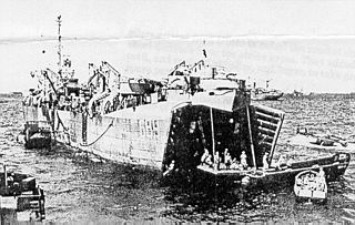
USS LST-689 was an LST-542-class tank landing ship built for the United States Navy during World War II. Late in her career she was renamed Daggett County (LST-689)—after Daggett County, Utah, the only U.S. Naval vessel to bear the name—but never saw active service under that name.

Kirksville is an unincorporated community in Indian Creek Township, Monroe County, in the U.S. state of Indiana.
Linwood was an unincorporated village in north-central Daggett County, Utah, United States, near the Wyoming state line.

Greendale was the community name given to a small ranching area in the Uinta Mountains of south-central Daggett County, Utah, United States.

This is a list of the National Register of Historic Places listings in Daggett County, Utah.
Cedar Creek is a ghost town in Box Elder County, Utah, United States. Founded in the 1860s, Cedar Creek was a farming town. Businesses included a school, an inn, and a store. The interstate highway system built through Cedar Creek and the nearby communities of Snowville and Park Valley. Cedar Creek was abandoned when weather conditions made farming difficult.
Bolivar, also known as Widows, is an unincorporated community in northern Jackson County, Alabama, United States. It is located on Alabama State Route 277, halfway between Bridgeport and Stevenson. It was originally called New Bolivar after many of the citizens of the old community of Bolivar, which was located near the current community of Edgefield near Stevenson, relocated to the railroad well after it was completed through the area in 1854. The old community faded away and New Bolivar never really grew. On original maps from the 1880s, New Bolivar was located where the former North Jackson Hospital stands on Alabama Highway 277.
Crouse Creek is a stream in the Uinta Mountains near the eastern edge of Daggett County, Utah, United States.
Matt Warner was a notable figure from the American Old West who was a farmer, cowboy, rancher, ferryman, cattle rustler, bank robber, justice of the peace, lawman, and bootlegger. Born Erastus Christiansen, he changed his name in his teens when he became an outlaw.

The John Jarvie Historic Ranch District, in the Utah portion of Brown's Park, is a historic district which was listed on the National Register of Historic Places in 1986.
Hiram M. Hook was an American politician who served as the first Mayor of Cheyenne, Wyoming, while it was still a part of the Dakota Territory with a population of around 600 people.


