Daggett County is a county in the northeastern corner of the U.S. state of Utah. As of the 2020 United States Census, the population was 935, making it the least populous county in Utah. Its county seat is Manila. The county was named for Ellsworth Daggett, the first surveyor-general of Utah. The small community of Dutch John, located near the state line with Colorado and Wyoming, became an incorporated town in January 2016.

Duchesne County is a county in the northeast part of the U.S. state of Utah. As of the 2020 United States Census, the population was 19,596. Its county seat is Duchesne, and the largest city is Roosevelt.

Uintah County is a county in the U.S. state of Utah. As of the 2020 United States Census the population was 35,620. Its county seat and largest city is Vernal. The county was named for the portion of the Ute Indian tribe that lived in the basin.
Washington County is a county in the southwestern corner of Utah, United States. As of the 2020 United States Census, the population was 180,279, making it the fifth-most populous county in Utah. Its county seat and largest city is St. George. The county was created in 1852 and organized in 1856. It was named after the first President of the United States, George Washington. A portion of the Paiute Indian Reservation is in western Washington County. Washington County comprises the St. George, UT Metropolitan Statistical Area.

Allenspark is an unincorporated town, a post office, and a census-designated place (CDP) located in and governed by Boulder County, Colorado, United States. The CDP is a part of the Boulder, CO Metropolitan Statistical Area. The Allenspark post office has the ZIP code 80510. At the United States Census 2020, the population of the Allenspark CDP was 568.
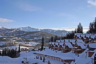
Big Sky is an unincorporated census-designated place (CDP) in Gallatin and Madison counties in southwestern Montana, United States. As of the 2010 census it had a population of 2,308. It is 45 miles (72 km) southwest of Bozeman. This unincorporated community straddles both counties, is not considered a town, and does not have a town government. The primary industry of the area is tourism.
Brown's Park or Browns Park, originally called Brown's Hole, is an isolated mountain valley along the Green River in Moffat County, Colorado and Daggett County, Utah in the United States. The valley begins in far eastern Utah, approximately 25 miles (40 km) downstream from Flaming Gorge Dam, and follows the river downstream into Colorado, ending at the Gates of Lodore in Dinosaur National Monument. Known as a haven for outlaws such as Butch Cassidy and Tom Horn during the late 19th century and the early 20th century, it is now the location of the Browns Park National Wildlife Refuge. It was also the birthplace of Ann Bassett. She and her sister, Josie Bassett, were considered female outlaws and girlfriends to several of Cassidy's Wild Bunch gang. It is the location of John Jarvie Historic Ranch, where, in 1880, Scotsman John Jarvie built a ranch along the Green River.
Denny, California refers to two little mining settlements named Denny in northwestern Trinity County, one in the upper New River watershed within the Trinity Alps Wilderness Area and the other twenty miles downstream along a one-way county roadway.

Dutch John is a town located in eastern Daggett County, Utah, United States, approximately 4 miles (6 km) northeast of the Flaming Gorge Dam on U.S. Route 191. The population was 145 at the 2010 census.
The Rankin Ranch is a historic ranch off Montana Highway 284, north of Townsend in rural Broadwater County, Montana. A National Historic Landmark, it was a longtime summer residence of Jeannette Rankin (1880-1973), whose 1916 election to the United States House of Representatives made her the first woman elected to the House. Her legacy includes a penchant for pacifism, women's rights, and social reform. She served another term from 1941 to 1943 when she was the only member of the House to oppose the declaration of war against Japan in 1941. A small portion of the ranch was designated a National Historic Landmark and listed on the National Register of Historic Places in 1976.
Linwood was an unincorporated village in north-central Daggett County, Utah, United States, near the Wyoming state line.

Desolation Canyon is a remote canyon on the Green River in eastern Utah, United States that is listed on the National Register of Historic Places (NRHP). It is said to be one of the most remote areas in the contiguous United States.
Bridgeport was the community name given to a small ranching area in far eastern Daggett County, Utah, United States, near the Colorado border. The Bridgeport store, saloon and post office were located on the north side of the Green River near the mouth of Jesse Ewing Canyon, near the western end of Browns Park.

Flaming Gorge is a census-designated place in Daggett County, Utah, United States. The population was 83 at the 2010 census.

The James Cant Ranch is a pioneer ranch complex in Grant County in eastern Oregon, United States. The ranch is located on both sides of the John Day River in the John Day Fossil Beds National Monument. The ranch was originally homesteaded by Floyd Officer in 1890. Officer sold the property to James Cant in 1910. Cant increased the size of the property and built a modern ranch complex on the west bank of the river. The National Park Service bought the ranch from the Cant family in 1975, and incorporated the property into the John Day Fossil Beds National Monument. The National Park Service used the main house as a visitor center until 2003. Today, the Cant Ranch complex is preserved as an interpretive site showing visitors an early 20th-century livestock ranch. The James Cant Ranch is listed on the National Register of Historic Places.
Grover is an unincorporated community in southwestern Wayne County, Utah, United States. Originally known as Carcass Creek, Grover is a small ranching community off the county's main recreational corridor.

The Josie Bassett Morris Ranch Complex comprises a small complex of buildings in what is now Dinosaur National Monument in northeastern Uintah County, Utah, United States. The complex is listed as a historic district on the National Register of Historic Places. It is where Josie Bassett Morris, a small-time rancher and occasional accused stock thief, lived until 1963. The ranch, located in Browns Park, Colorado, was established by the Bassett family in the 1870s. Josie grew up there, and through her family came to know a number of outlaws, including Butch Cassidy, who frequented the area. Morris established her own homestead on Cub Creek in Utah in 1914 with help from friends Fred McKnight and the Chew family.

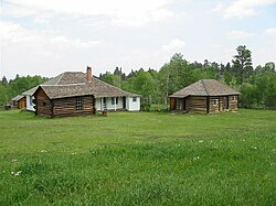
Swett Ranch is a ranch in Daggett County, Utah, United States, a part of which is listed on the National Register of Historic Places (NRHP).

Lucia is a hamlet located 22 miles (35 km) south of Big Sur Village and 38 miles (61 km) north of Hearst Castle. The area is sparsely settled