
Lund is an unincorporated village located in the Escalante Valley of northwestern Iron County, Utah, United States, approximately 35 miles (56 km) northwest of Cedar City. The town, established in the early twentieth century, was a station stop on the Los Angeles and Salt Lake Railroad, and was a community center for early twentieth century homesteaders. The area's population was never large, however, and most early settlers were unsuccessful due to the region's harsh and arid climate.
Black Rock is an unincorporated community and near-ghost town in the Beaver Bottoms in southern Millard County, Utah, United States, approximately 20 miles (32 km) north of Milford.

Gold Hill is an unincorporated community in far western Tooele County, Utah, located near the Nevada state line.
Ajax is a ghost town located in the Rush Valley area of southeastern Tooele County, Utah, United States. The town grew up around a unique department store started in 1869 by a Welsh immigrant named William Ajax. He operated the Ajax Underground Store until his death in 1899, and the settlement came to an end as the other residents left by 1900. All that remains today is a hole in the ground, with a historical marker standing nearby.
Dover is a ghost town located in Sanpete County, Utah, United States. The site lies west of Fayette across the Sevier River.
Mohrland is a ghost town located in Emery County, Utah, United States. Lying in Cedar Creek Canyon near the Carbon County line, Mohrland was Emery County's largest coal mining town, with a history more typical of Carbon County's coal camps than of most Emery County communities.
La Plata is a ghost town on the southern end of Cache County, Utah, United States. Located in the Bear River Mountains on a small tributary of the east fork of the Little Bear River, La Plata was a short-lived silver mining boomtown in the 1890s.

Greendale was the community name given to a small ranching area in the Uinta Mountains of south-central Daggett County, Utah, United States.

Widtsoe is a ghost town in Garfield County, Utah, United States. Located in John's Valley northeast of Bryce Canyon and along the Sevier River at the mouth of Sweetwater Creek, the town existed from about 1908 to 1936.
Dewey is a ghost town in along the Colorado River in southeastern Grand County, Utah, United States.
Blue Creek is a ghost town in the Blue Creek Valley in northeastern Box Elder County, Utah, United States.
Grass Creek is a ghost town in Summit County, Utah, United States. Lying some 8 miles (13 km) northeast of Coalville, it was once an important coal mining town. Grass Creek was inhabited circa 1860–1940.

Duncan's Retreat is a ghost town located just off Utah State Route 9 in the eastern part of Washington County, in southwestern Utah, United States. Lying some 3 miles (4.8 km) east of Virgin and just southwest of Zion National Park, Duncan's Retreat was inhabited about 1861–1895.
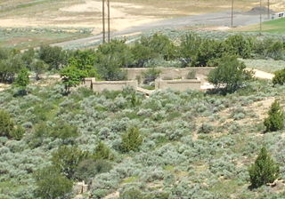
Knightsville is a ghost town located in the East Tintic Mountains on the northern slope of Godiva Mountain, approximately 2 miles (3.2 km) east of Eureka, in the northeastern corner of Juab County in central Utah, United States. A silver mining camp, Knightsville was established and operated as a company town by local mining entrepreneur Jesse Knight. The town was inhabited from 1896 until approximately 1940.
Peerless is a ghost town in Carbon County, Utah, United States. It is located just 3 miles (4.8 km) west of Helper.
Cedar Creek is a ghost town in Box Elder County, Utah, United States. Founded in the 1860s, Cedar Creek was a farming town. Businesses included a school, an inn, and a store. The interstate highway system built through Cedar Creek and the nearby communities of Snowville and Park Valley. Cedar Creek was abandoned when weather conditions made farming difficult.
Consumers is a ghost town in Carbon County, Utah, United States. It is located in the Gordon Valley near several other former coal mining communities that also are now ghost towns. It is less than a mile from the ghost town of National, and also quite near to Clear Creek.
Linwood is a hamlet and census-designated place (CDP) in the town of York, Livingston County, New York, United States. Its population was 74 as of the 2010 census. Linwood had a post office until February 6, 1993; it still has its own ZIP code, 14486.
Diamond is a ghost town in eastern Juab County, Utah, United States. The Diamond Cemetery is listed on the National Register of Historic Places.
Cedarview is a ghost town in eastern Duchesne County, Utah, United States,


