Bromsberrow

Last updated

Bromsberrow
Bromsberrow Heath Post Office.jpg
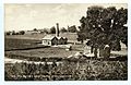
Bromsberrow Heath, the largest settlement in the parish
Gloucestershire UK location map.svg
Red pog.svg
Bromsberrow
Location within Gloucestershire
Population407 (2011) [1]
OS grid reference SO7434
District
Shire county
Region
Country England
Sovereign state United Kingdom
Post town LEDBURY
Postcode district HR8
Dialling code 01531
Police Gloucestershire
Fire Gloucestershire
Ambulance South Western
UK Parliament
List of places
UK
England
Gloucestershire
52°00′14″N2°22′49″W / 52.00382°N 2.38016°W / 52.00382; -2.38016 Coordinates: 52°00′14″N2°22′49″W / 52.00382°N 2.38016°W / 52.00382; -2.38016

Bromsberrow (or Bromesberrow) is part of the Forest of Dean district. The village is close to the meeting point between Gloucestershire, Herefordshire, and Worcestershire. The nearest town is Ledbury, about four miles north in Herefordshire.

Contents

A resident of the village named Emily Bishop (c1879-1961) was recorded extensively singing traditional folk songs by the folklorist Peter Kennedy in 1952. [2]

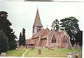
The village was briefly home to Richard Hammond, the former Top Gear presenter, who resided on a farm next to St. Mary's Church. [3]

Identify as Bremesbyrig

Anglo-Saxon Chronicle states that in 910 Aethelflaed constructed a stronghold at "Bremesbyrig"; the location is suspected either being Bromsberry or Bromsgrove. [4] [5]

Related Research Articles

<span class="mw-page-title-main">Worcestershire</span> County of England

Worcestershire is a county in the West Midlands of England. The area that is now Worcestershire was absorbed into the unified Kingdom of England in 927, at which time it was constituted as a county.

<span class="mw-page-title-main">Kidderminster</span> Human settlement in England

Kidderminster is a large market and historic minster town and civil parish in Worcestershire, England, 17 miles (27 km) south-west of Birmingham and 15 miles (24 km) north of Worcester. Located north of the River Stour and east of the River Severn, in the 2011 census, it had a population of 55,530. The town is twinned with Husum, Germany.

<span class="mw-page-title-main">Hereford</span> City in Herefordshire, England

Hereford is a cathedral city, civil parish and the county town of Herefordshire, England. It lies on the River Wye, approximately 16 miles (26 km) east of the border with Wales, 24 miles (39 km) south-west of Worcester and 23 miles (37 km) north-west of Gloucester. With a population of 53,112 in 2021 it is by far the largest settlement in Herefordshire.

<span class="mw-page-title-main">Hwicce</span> Tribal kingdom in Anglo-Saxon England

Hwicce was a tribal kingdom in Anglo-Saxon England. According to the Anglo-Saxon Chronicle, the kingdom was established in 577, after the Battle of Deorham. After 628, the kingdom became a client or sub-kingdom of Mercia as a result of the Battle of Cirencester.

<span class="mw-page-title-main">Leominster</span> Town in Herefordshire, England

Leominster is a market town in Herefordshire, England, at the confluence of the River Lugg and its tributary the River Kenwater. The town is 12 miles north of Hereford and seven miles south of Ludlow in Shropshire. With a population of 11,700, Leominster is the largest of the five towns in the county.

<span class="mw-page-title-main">Bromsgrove</span> Human settlement in England

Bromsgrove is a town in Worcestershire, England, about 16 miles (26 km) northeast of Worcester and 13 miles (21 km) southwest of Birmingham city centre. It had a population of 29,237 in 2001. Bromsgrove is the main town in the larger Bromsgrove District. In the Middle Ages it was a small market town; primarily producing cloth through the early modern period. In the eighteenth and nineteenth centuries it became a major centre for nail making.

<span class="mw-page-title-main">Bromyard</span> Market town in Herefordshire, England

Bromyard is a town in Herefordshire, England, in the valley of the River Frome. It lies near the county border with Worcestershire on the A44 between Leominster and Worcester. Bromyard has a number of traditional half-timbered buildings, including some of the pubs, and the parish church is Norman. For centuries, there was a thriving livestock market. The town is twinned with Athis-de-l'Orne, Normandy.

Border Morris is a collection of individual local dances from villages along the English side of the Wales–England border in the counties of Herefordshire, Worcestershire and Shropshire. They are part of the Morris dance tradition.

<span class="mw-page-title-main">History of Worcestershire</span>

The area now known as Worcestershire has had human presence for over half a million years. Interrupted by two ice ages, Worcestershire has had continuous settlement since roughly 10,000 years ago. In the Iron Age, the area was dominated by a series of hill forts, and the beginnings of industrial activity including pottery and salt mining can be found. It seems to have been relatively unimportant during the Roman era, with the exception of the salt workings.

The history of Herefordshire starts with a shire in the time of Athelstan (895–939), and Herefordshire is mentioned in the Anglo-Saxon Chronicle in 1051. The first Anglo-Saxon settlers, the Magonsætan, were a sub-tribal unit of the Hwicce who occupied the Severn valley. The Magonsætan were said to be in the intervening lands between the Rivers Wye and Severn. The undulating hills of marl clay were surrounded by the Welsh mountains to the west; the Malvern Hills to the east; the Clent Hills of the Shropshire borders to the north, and the indeterminate extent of the Forest of Dean to the south. The shire name first recorded in the Anglo-Saxon Chronicle was derived from "Here-ford", Old English for "Army crossing", the location for the city.

<span class="mw-page-title-main">Wychbold</span> Human settlement in England

Wychbold is a village in the Wychavon district of Worcestershire. The village is situated on the A38 between Droitwich Spa and Bromsgrove, and by Junction 5 of the M5 motorway.

<span class="mw-page-title-main">Whitbourne, Herefordshire</span> Human settlement in England

Whitbourne is a village in Eastern Herefordshire, England on the banks of the River Teme and close to the A44. It is close to Bringsty Common on one side and the border of Worcestershire on the other. Around 400 people live in the village itself with about as many residing in surrounding houses and farms. It has a Welsh Water pumping station, which supplies the town of Bromyard and the surrounding area and which flooded in July 2007.

<span class="mw-page-title-main">Welland, Worcestershire</span> Human settlement in England

Welland is a village and civil parish in the administrative district of Malvern Hills in the county of Worcestershire, England. It has a combined parish council with Little Malvern, with 9 of the 11 councillors. It is about 6 miles (9.7 km) from the town of Malvern, 15 miles from the city of Worcester, and 18 miles from the city of Gloucester. It is surrounded by farms and common land, and is part of the informal region referred to as The Malverns.

Dives and Lazarus is traditional English folk song listed as Child ballad 56 and number 477 in the Roud Folk Song Index. It is considered a Christmas carol and based on the parable of the rich man and Lazarus. The song traditionally used a variety of tunes, but one particular tune, published by Lucy Broadwood in 1893 and used in other traditional songs, inspired many notable works and appeared in several pieces composed by Ralph Vaughan Williams.

"A Virgin Unspotted" is a Christmas carol. It originates from 1661, when the oldest known version was written in "New Carolls for this Merry Time of Christmas". It is said to be based on "A Virgin Most Pure", a similar carol. This carol is in a 3/4 rhythm in the verses, but speeds up to a 6/8 rhythm in the chorus.

<span class="mw-page-title-main">Evolution of Worcestershire county boundaries since 1844</span> This article is about the evolution and complexities of Worcestershires county boundaries.

The administrative boundaries of Worcestershire, England have been fluid for over 150 years since the first major changes in 1844. There were many detached parts of Worcestershire in the surrounding counties, and conversely there were islands of other counties within Worcestershire. The 1844 Counties Act began the process of eliminating these, but the process was not completed until 1966, when Dudley was absorbed into Staffordshire.

<span class="mw-page-title-main">Salwarpe</span> Human settlement in England

Salwarpe is a small village and civil parish in the Wychavon district of Worcestershire, England, less than two miles south west of Droitwich, but in open country. The name is also spelled Salwarp, and in the time of John Leland was recorded as Salop. Since 2003, Salwarpe has shared a parish council with Hindlip and Martin Hussingtree.

<span class="mw-page-title-main">St Mary's Church, Dymock</span>

St Mary's Church, Dymock is a Church of England parish church in the center of the village of Dymock in Gloucestershire, England. It is a Grade I listed building.

References

  1. "Parish population 2011". Archived from the original on 2 April 2015. Retrieved 26 March 2015.
  2. "Emily Bishop, Bromsberrow Heath, Herefordshire 1952 - Peter Kennedy Collection - World and traditional music | British Library - Sounds". sounds.bl.uk. Retrieved 7 January 2021.
  3. Stephenson, David (2 March 2008). "Hamster's drive to be new Parky". Express. Retrieved 19 August 2020.
  4. Swanton, Michael (1998). The Anglo-Saxon Chronicle. Psychology Press. pp. 94–95. ISBN   978-0-415-92129-9 . Retrieved 1 May 2020.
  5. Dyer, Christopher (2000). Bromsgrove: a small town in Worcestershire in the Middle Ages. Occasional Publications. Vol. 9. Worcestershire Historical Society. ISSN   0140-9913.

Commons-logo.svg Media related to Bromesberrow at Wikimedia Commons