
Clarence Valley Council is a local government area in the Northern Rivers region of New South Wales, Australia.

Morningside is a southside suburb in the City of Brisbane, Queensland, Australia. In the 2021 census, Morningside had a population of 11,755 people.

Ceduna is a town in South Australia located on the shores of Murat Bay on the west coast of Eyre Peninsula. It lies west of the junction of the Flinders and Eyre Highways around 786 km northwest of the capital Adelaide. The port town/suburb of Thevenard lies 3 km to the west on Cape Thevenard. It is in the District Council of Ceduna, the federal Division of Grey, and the state electoral district of Flinders.

Peregian Beach is a beach and small coastal town on the Sunshine Coast, Queensland, Australia. It is a suburb split between two local government areas with the eastern coastal in the Shire of Noosa and the western hinterland part in the Sunshine Coast Region. In the 2021 census, the suburb of Peregian Beach had a population of 4,972 people.

Bucklands Beach is a suburb 13 kilometres (8.1 mi) east of Auckland's CBD in New Zealand. The suburb is in the Howick ward, one of the thirteen administrative divisions of Auckland Council.

Yamba is a town in the Northern Rivers region of New South Wales, Australia located at the mouth of the Clarence River.

Donald is a town in Victoria, Australia, located on the Richardson River, at the junction of Sunraysia Highway and Borung Highway, in the Shire of Buloke. At the 2021 census, it had a population of 1,472.
Eastern Beach is a suburb of Auckland, New Zealand. Located on the eastern city of the city centre, the suburb is in the Howick ward, one of the thirteen administrative divisions of Auckland City. Its most common attraction is a popular white-sand palm fringed beach, also called Eastern Beach, with summer temperatures attracting thousands of people from neighbouring suburbs to the beach to enjoy the shallow waters, and shops and parks within close vicinity. At the southern end of the beach is a boat ramp giving high-medium tide access to the dedicated water skiing zone adjacent to the beach. This was a popular area for gathering Pipi and Cockles, but overuse has seen a rāhui or ban placed on the beach. It is part of the Bucklands Beach peninsula.

Boreen Point is a rural locality in the Shire of Noosa, Queensland, Australia. In the 2016 census, Boreen Point had a population of 328 people. The town of Boreen is located within the locality beside the lake, but the town name is rarely used with Boreen Point being the name in common usage.

Angourie is a coastal village in the Clarence Valley Council of New South Wales, Australia. Angourie is located 5 km south of Yamba, New South Wales, and is at the northern tip of Yuraygir National Park. Towns that surround Angourie are Yamba and Wooloweyah.

Maclean is a town in Clarence Valley local government area in the Northern Rivers region of New South Wales, Australia. It is on the Clarence River and near the Pacific Highway. At the 2021 census, Maclean had a population of 2,778, total urban area including Townsend and Gulmarrad is more than 8,304. The Maclean, Yamba and Iluka area known as the Lower Clarence had a combined population of 17,533. Its industries are tourism, sugar cane production, farming and river-prawn trawling. Together with Grafton, Maclean is the shared administrative centre for the Clarence Valley Council local government area.
Heretaunga is a suburb of the city of Upper Hutt, located in the lower (southern) North Island of New Zealand. The settlement, one of the older suburbs in the Hutt Valley, dates from the 1840s when European settlers sought country sections. A prime example of a "leafy" suburb, Heretaunga includes quiet tree-lined streets. It is characterised by large houses, often Edwardian or from the mid-20th century.
The Rathmines is a suburb of the City of Lake Macquarie in New South Wales, Australia on the western shore of Lake Macquarie between the towns of Toronto and Morisset.
Bonnells Bay is a suburb of the City of Lake Macquarie in New South Wales, Australia on a peninsula east of the town of Morisset on the western side of Lake Macquarie.

Como is a rural locality in the Shire of Noosa, Queensland, Australia. In the 2021 census, Como had a population of 54 people.
Elliott Heads is a coastal town and locality in the Bundaberg Region, Queensland, Australia. In the 2021 census, the locality of Elliott Heads had a population of 1,160 people.
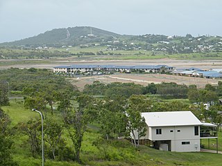
Zilzie is a coastal locality in the Livingstone Shire, Queensland, Australia. In the 2021 census, Zilzie had a population of 2,846 people.

New Beith is a rural residential locality in the City of Logan, Queensland, Australia. In the 2016 census, New Beith had a population of 4,081 people.
The Yaygir, Yuraygir, or Yaegl, are an Australian Aboriginal tribe who traditionally live and lived in and around Yamba and Maclean, New South Wales.
Charlestown is a locality in the South Burnett Region, Queensland, Australia. In the 2021 census, Charlestown had a population of 79 people.
