
The Virgin Islands National Park is an American national park preserving about 60% of the land area of Saint John in the United States Virgin Islands, as well as more than 5,500 acres of adjacent ocean, and nearly all of Hassel Island, just off the Charlotte Amalie, Saint Thomas harbor.

Saint John is one of the Virgin Islands in the Caribbean Sea and a constituent district of the United States Virgin Islands (USVI), an unincorporated territory of the United States.

Le Moule is the sixth-largest commune in the French overseas department of Guadeloupe. It is located on the northeast side of the island of Grande-Terre.

The Jarrell Plantation State Historic Site is a former cotton plantation and state historic site in Juliette, Georgia, United States. Founded as a forced-labor farm worked by John Jarrell and the African American people he enslaved, the site stands today as one of the best-preserved examples of a "middle class" Southern plantation. The Jarrell Plantation's buildings and artifacts all came from the Jarrell family, who farmed the land for over 140 years. Located in the red clay hills of the Georgia piedmont, It was added to the National Register of Historic Places in 1973. It is a Georgia state park in Jones County.

Cinnamon Bay Plantation is an approximately 300-acre (1.2 km2) property situated on the north central coast of Saint John in the United States Virgin Islands adjacent to Cinnamon Bay. The land, part of Virgin Islands National Park, was added to the United States National Register of Historic Places on July 11, 1978. Archaeological excavations of the land document ceremonial activity of the Taínos, as well as historic remains of plantation ruins.

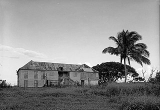
Reef Bay Sugar Factory Historic District is a historic section of Saint John, United States Virgin Islands located on the south central coast adjacent to Reef Bay. The land is the site of a sugar factory. The property was added to the U.S. National Register of Historic Places on July 23, 1981.

Sugar production in the United States Virgin Islands was an important part of the economy of the United States Virgin Islands for over two hundred years. Long before the islands became part of the United States in 1917, the islands, in particular the island of Saint Croix, was exploited by the Danish from the early 18th century and by 1800 over 30,000 acres were under cultivation, earning Saint Croix a reputation as the "Garden of the West Indies". Since the closing of the last sugar factory on Saint Croix in 1966, the industry has become only a memory.
Green Kay is a settlement on the island of Saint Croix in the United States Virgin Islands. It is located 3.3 miles (5.3 km) east of Christiansted.
Sion Hill is a settlement on the island of Saint Croix, in the United States Virgin Islands.
The Bethlehem Middle Works Historic District, in King's Quarter, in Southcentral, in Saint Croix, U.S. Virgin Islands, was listed on the National Register of Historic Places in 1988. It is also known as Estate Bethlehem Middle Works and as Bethlehem Middle Works. It is a 34 acres (14 ha) historic district which included 26 contributing buildings, two contributing structures, and four contributing sites.

The Estate Carolina Sugar Plantation near Coral Bay on Saint John, U.S. Virgin Islands is a historic sugar plantation and later rum distillery.

The Estate Brewers Bay, located near the University of the Virgin Islands and John Brewers Bay Beach about 2 miles (3.2 km) west of Charlotte Amalie on Saint Thomas, U.S. Virgin Islands, is a historic sugar plantation which was listed on the National Register of Historic Places in 1978.
Liever Marches Bay is a shallow bight on the north shore of the island of St. John, U.S. Virgin Islands, just east of Brown Bay, towards the eastern end of the island. It has a 450 feet (140 m) shingle beach.
The L'Esperance Historic District, located east of Cruz Bay off Center Line Rd., on Saint John in the U.S. Virgin Islands, is a historic district which was listed on the National Register of Historic Places in 1981. It is located within Virgin Islands National Park. The listing included two contributing structures and nine contributing sites on 6.3 acres (2.5 ha).

Dennis Bay Historic District is a historic district which was listed on the National Register of Historic Places in 1981. It is located northeast of Cruz Bay off North Shore Rd., in Virgin Islands National Park. The plantation was claimed and cleared by 1728 to operate as a sugar cane plantation.
Estate Botany Bay, near Charlotte Amalie on Saint Thomas in the U.S. Virgin Islands, was listed on the National Register of Historic Places in 1976.
The Jossie Gut Historic District, in Reef Bay Valley / Reef Bay, Virgin Islands, was listed on the National Register of Historic Places in 1981. The listing included two contributing structures and four contributing sites. It is included in Virgin Islands National Park. It is located west of Coral Bay off Center Line Road, in the Central area of the park. It includes remains of a horsemill.
The More Hill Historic District in the East End area of Saint John in the U.S. Virgin Islands, was listed on the National Register of Historic Places in 1981.

Estate Butler's Bay, on the island of Saint Croix in the U.S. Virgin Islands, was established as a sugar plantation by 1764. It was listed on the National Register of Historic Places in 1978. The listing included five contributing buildings, a contributing structure, and five contributing sites.
Hacienda Azucarera La Esperanza is a former 2265-acre sugarcane plantation located in the Manatí river valley in the municipality of Manatí, Puerto Rico which was founded in the 1830s and, by the 1860s, was one of the largest in the island. It remained operational from 1830 to 1880.

