Catherineberg Sugar Mill Ruins

Last updated
Catherineberg-Jockumsdahl-Herman Farm
Catherineberg Sugar Mill Ruins; Saint John, United States Virgin Islands.jpg
Catherineberg Sugar Mill Ruins
USA Virgin Islands location map.svg
Red pog.svg
Nearest city Cruz Bay, U.S. Virgin Islands
Coordinates 18°20′48″N64°45′41″W / 18.34667°N 64.76139°W / 18.34667; -64.76139
Area15 acres (6.1 ha)
MPS Virgin Islands National Park MRA
NRHP reference No. 78000270 [1]
Added to NRHPMarch 30, 1978

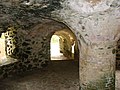
Catherineberg Sugar Mill Ruins is an historic site located in the Virgin Islands National Park, east of Cruz Bay on Saint John, U.S. Virgin Islands. The ruins are an example of an 18th-century sugar and rum factory.

Contents

To reach Catherineberg, turn north on John Head Road from Centerline Road. There is room for several cars to park right next to the windmill.

The "most impressive" ruin is that of an unusual windmill tower. [2]

History

A sugar plantation from the 18th to the 19th centuries, the farm eventually became land for grazing cattle.

In 1733 one of the first significant slave rebellions in the New World took place on Saint John when African slaves took over the island for six months. During the slave revolt, the farm was the headquarters of the Amina warriors.

Today the sugar mill ruins are located in a protected area in the Virgin Islands National Park. It is one of 17 properties in the park that were listed on the U.S. National Register of Historic Places by 1981. [3] The property was added to the U.S. National Register of Historic Places on March 30, 1978. [1]

Architecture

Catherineberg Sugar Mill Ruins are an example of an 18th-century sugar and rum factory. The documented ruins on the site are the windmill, a still, a factory, a horse mill, a stable and oxpound, and two unidentified structures. [2]

Scenes around the Catherineberg Sugar Mill Site:

See also

Related Research Articles

Saint Croix is an island in the Caribbean Sea, and a county and constituent district of the United States Virgin Islands (USVI), an unincorporated territory of the United States.

<span class="mw-page-title-main">Virgin Islands National Park</span> 14,700 acres in St. John, Virgin Islands (US) managed by the National Park Service

The Virgin Islands National Park is an American national park preserving about 60% of the land area of Saint John in the United States Virgin Islands, as well as more than 5,500 acres of adjacent ocean, and nearly all of Hassel Island, just off the Charlotte Amalie, Saint Thomas harbor.

<span class="mw-page-title-main">Hassel Island, U.S. Virgin Islands</span> United States historic place

Hassel Island is a small island of the U.S. Virgin Islands, a United States territory located in the Caribbean Sea. Hassel Island lies in the Charlotte Amalie harbor just south of Saint Thomas and east of Water Island, with which it is part of the sub-district of Water Island.

<span class="mw-page-title-main">Mount Healthy windmill</span> Ruined windmill in British Virgin Islands

Mount Healthy windmill is a ruined windmill on the north side of Tortola in the British Virgin Islands. It was formerly used during the plantation era of the Territory to crush sugar cane. After the collapse of the sugar economy in the early nineteenth century the windmill fell into disuse and became a ruin. It crushed cane for the sugar mill and rum distillery in nearby Brewer's Bay. There are other ruins like the Boiling House, remnants of the Animal Mill Round, distillery, hospital, storage, shed, and housing. The 18th century windmill belonged to the area's wealthiest planter. Slaves harvested and processed sugar cane into sugar at this extensive sugarcane plantation.

<span class="mw-page-title-main">Fort Frederik</span> United States historic place

Fort Frederik, also known as Frederiksfort, is a U.S. National Historic Landmark in Frederiksted, United States Virgin Islands. It was built between 1752 and 1760 by Denmark-Norway to defend the economic interests of the natural deep water port of Frederiksted and to ward off pirates. It has red and white painted walls, making it quite different then yellow and white of Fort Christiansværn on the other side of the island. It is located at the north end of Frederiksted, in St. Croix, south of the junction of Mahogany Road and VI 631. It should not be confused with Frederiks Fort, Fortberg Hill, on St. John, which is also listed on the National Register of Historic Places.

<span class="mw-page-title-main">Cinnamon Bay Plantation</span> United States historic place

Cinnamon Bay Plantation is an approximately 300-acre (1.2 km2) property situated on the north central coast of Saint John in the United States Virgin Islands adjacent to Cinnamon Bay. The land, part of Virgin Islands National Park, was added to the United States National Register of Historic Places on July 11, 1978. Archaeological excavations of the land document ceremonial activity of the Taínos, as well as historic remains of plantation ruins.

<span class="mw-page-title-main">Reef Bay Sugar Factory Historic District</span> United States historic place

Reef Bay Sugar Factory Historic District is a historic section of Saint John, United States Virgin Islands located on the south central coast adjacent to Reef Bay. The land is the site of a sugar factory. The property was added to the U.S. National Register of Historic Places on July 23, 1981.

<span class="mw-page-title-main">Sugar production in the Danish West Indies</span> Historical sugar production in the US Virgin Islands

Sugar production in the United States Virgin Islands was an important part of the economy of the United States Virgin Islands for over two hundred years. Long before the islands became part of the United States in 1917, the islands, in particular the island of Saint Croix, was exploited by the Danish from the early 18th century and by 1800 over 30,000 acres were under cultivation, earning Saint Croix a reputation as the "Garden of the West Indies". Since the closing of the last sugar factory on Saint Croix in 1966, the industry has become only a memory.

Green Kay is a settlement on the island of Saint Croix in the United States Virgin Islands. It is located 3.3 miles (5.3 km) east of Christiansted.

Grove Place is a settlement on the island of Saint Croix in the United States Virgin Islands. It was added to the National Register of Historic Places in 1978.

Sion Hill is a settlement on the island of Saint Croix, in the United States Virgin Islands.

<span class="mw-page-title-main">Whim, U.S. Virgin Islands</span> Village in Saint Croix, United States Virgin Islands

Whim is a settlement on the island of Saint Croix in the United States Virgin Islands.

<span class="mw-page-title-main">Estate Little Princess</span> United States historic place

Estate Little Princess is a historic plantation site located northwest of Christiansted in Saint Croix, U.S. Virgin Islands. It was first owned by governor Frederik Moth in 1738 and rests on 25 acres of land. As of 2011 the estate is under ownership of The Nature Conservancy and serves as headquarters for the Eastern Caribbean/Virgin Islands programs. The property has been turned into a nature preserve and historical tours are given as well. The site was listed on the National Register of Historic Places on June 9, 1980.

The Bethlehem Middle Works Historic District, in King's Quarter, in Southcentral, in Saint Croix, U.S. Virgin Islands, was listed on the National Register of Historic Places in 1988. It is also known as Estate Bethlehem Middle Works and as Bethlehem Middle Works. It is a 34 acres (14 ha) historic district which included 26 contributing buildings, two contributing structures, and four contributing sites.

<span class="mw-page-title-main">Estate Judith's Fancy</span> United States historic place

Estate Judith's Fancy, subdistrict of Saint Croix, U.S. Virgin Islands, 4 miles (6.4 km) northwest of Christiansted is a former sugarcane plantation whose great house was built in 1733. Its surviving 3.6 acres (1.5 ha) property was listed on the National Register of Historic Places in 1978. The listing included six contributing sites.

<span class="mw-page-title-main">Estate Carolina Sugar Plantation</span> United States historic place

The Estate Carolina Sugar Plantation near Coral Bay on Saint John, U.S. Virgin Islands is a historic sugar plantation and later rum distillery.

Estate Grove Place, at Grove Place in the Northwest subdistrict near Frederiksted on St. Croix, U.S. Virgin Islands, is a historic plantation which was listed on the National Register of Historic Places in 1978.

<span class="mw-page-title-main">Estate Brewers Bay</span> United States historic place

The Estate Brewers Bay, located near the University of the Virgin Islands and John Brewers Bay Beach about 2 miles (3.2 km) west of Charlotte Amalie on Saint Thomas, U.S. Virgin Islands, is a historic sugar plantation which was listed on the National Register of Historic Places in 1978.

Slob Historic District, near Christiansted, Virgin Islands, is a historic district which was listed on the National Register of Historic Places in 1987. The listing included nine contributing buildings, three contributing structures, and a contributing site on 9 acres (3.6 ha).

Estate La Reine, near Christiansted on Saint Croix in the U.S. Virgin Islands, dates from around 1750. It was listed on the National Register of Historic Places in 1980. The listing included three contributing buildings, two contributing structures, and a contributing site.

References

  1. 1 2 "National Register Information System". National Register of Historic Places . National Park Service. April 15, 2008.
  2. 1 2 Frederik C. Gjessing (February 1976). "National Register of Historic Places Inventory/Nomination: Cathrineberg Jockumsdahl Herman Farm / Hammer Farm, Herman Farm". National Park Service . Retrieved January 10, 2017. with seven photos from 1973 and 1976
  3. Frederik C. Gjessing (August 2, 1978). "National Register of Historic Places Inventory/Nomination: Virgin Islands National Park Multiple Resource Area". National Park Service . Retrieved January 9, 2017.