
The Virgin Islands National Park is an American national park preserving about 60% of the land area of Saint John in the United States Virgin Islands, as well as more than 5,500 acres of adjacent ocean, and nearly all of Hassel Island, just off the Charlotte Amalie, Saint Thomas harbor.
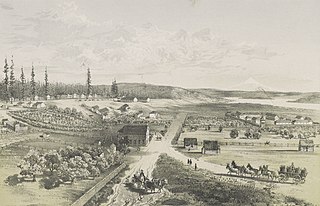
Fort Vancouver National Historic Site is a United States National Historic Site located in the states of Washington and Oregon. The National Historic Site consists of two units, one located on the site of Fort Vancouver in modern-day Vancouver, Washington; the other being the former residence of John McLoughlin in Oregon City, Oregon. The two sites were separately given national historic designation in the 1940s. The Fort Vancouver unit was designated a National Historic Site in 1961, and was combined with the McLoughlin House into a unit in 2003.
San Juan National Historic Site in the Old San Juan section of San Juan, Puerto Rico, is a National Park Service-managed historic site which protects and interprets colonial-era forts such as Castillo San Felipe del Morro, bastions, powder houses, and three fourths of the old city wall.
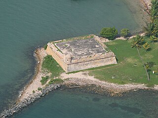
Fortín San Juan de la Cruz, known locally as El Cañuelo, was built on Isla de Cabras, at the western end of the entrance to San Juan Bay, in Puerto Rico. The square coastal fort has massive sandstone walls that date back to the 1630s. Although the U.S. Navy bombarded the fort in 1898, the fort survived. Today the fort is part of the San Juan National Historic Site, which is listed as a UNESCO World Heritage Site and on the National Register of Historic Places. One cannot enter the fort, but one may walk around it.

Cruz Bay, U.S. Virgin Islands is the main town on the island of Saint John in the United States Virgin Islands. According to the 2000 census, Cruz Bay had a population of 2,743.

Salt River Bay National Historic Park and Ecological Preserve is a unit of the National Park Service on the island of St. Croix in the U.S. Virgin Islands. It preserves upland watersheds, mangrove forests, and estuarine and marine environments that support threatened and endangered species. It also contains the Columbus Landing Site, a National Historic Landmark that is the only known site where members of a Columbus expedition set foot on what is now United States territory. The site is marked by Fort Salé, a remaining earthworks fortification from the French period of occupation, about 1617. The park also preserves prehistoric and colonial-era archeological sites including the only existing example of a ball court in the US Virgin Islands.

Fort Baker is one of the components of California's Golden Gate National Recreation Area. The Fort, which borders the City of Sausalito in Marin County and is connected to San Francisco by the Golden Gate Bridge, served as an Army post until the mid-1990s, when the headquarters of the 91st Division moved to Parks Reserve Forces Training Area. It is located opposite Fort Point at the entrance to the San Francisco Bay.

Fort O'Brien State Historic Site, also known as Fort Machias, preserves the remains of a fort located in Machiasport, Maine that was built and destroyed three times over a 90-year period. It was involved in military actions during the American Revolutionary War and the War of 1812, and was listed on the National Register of Historic Places. It is now managed by the Maine Department of Conservation's Bureau of Parks and Lands, and is open between Memorial Day and Labor Day.

Fort Abercrombie State Historical Park, also known as the Fort Abercrombie State Historic Site, is an Alaska state park on Kodiak Island, Alaska. It includes 182 acres (74 ha) of land at the end of Miller Point, located on the eastern shore of Kodiak Island northeast of the city of Kodiak. The park, established in 1969, is noted for its historical World War II fortifications and its scenery, which includes bluffs overlooking the ocean, spruce forests, and meadows. The site was named in honor of the early Alaska explorer and United States Army officer Lt. Col. William R. Abercrombie. The fortifications, whose surviving elements include gun emplacements, underground magazines, and foundational remnants of buildings, were built in 1941 and abandoned after the war ended, having seen no action.

The Fort Point Light, or Fort Point Light Station, is located in Fort Point State Park, in Stockton Springs, Maine. A lighthouse at this point has served as an active aid to navigation since 1835; the present lighthouse dates to 1857, and is listed on the National Register of Historic Places.

Catherineberg Sugar Mill Ruins is an historic site located in the Virgin Islands National Park, east of Cruz Bay on Saint John, U.S. Virgin Islands. The ruins are an example of an 18th-century sugar and rum factory.
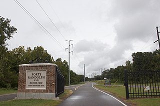
Fort Buhlow is an American Civil War fort site located in Pineville, Louisiana. It was added to the National Register of Historic Places on June 1, 1981. It was one of two forts built for the Confederate States Army by local plantation slave labor in March 1865 to prevent anticipated Union attacks. Alphonse Buhlow was the military engineer for the construction of the forts and this one was named for him.

The Connecticut Valley Railroad Roundhouse and Turntable Site is a former railroad facility located in Fort Saybrook Monument Park off Main Street in Old Saybrook, Connecticut. The roundhouse and turntable were built in 1871 by the Connecticut Valley Railroad, which was later acquired by the New York, New Haven and Hartford Railroad. The rail facilities are built partly on the archaeological remains of Fort Saybrook, the main fortification of the 17th-century Saybrook Colony, and are the only surviving remnant of what was once a large facility, with an icehouse, coal bin, steamboat dock, depot, and signal tower. Archaeological remains of these other facilities are believed to lie under other parts of the park and adjacent properties. The exposed facilities were excavated in 1981-2. Both structures were added to the National Register of Historic Places on April 28, 1994.

Forts Baker, Barry, and Cronkhite near Sausalito, California is a combination of historic sites that, as a group, was listed on the National Register of Historic Places (NRHP) in 1973. Fort Baker is a major part.

Fort Clifton Archeological Site is a historic American Civil War fort archaeological site located at Fort Clifton Park, Colonial Heights, Virginia. The park is the site of Fort Clifton on the Appomattox River where five Union ships sailed on Confederate troops on June 11, 1864. The Confederate Battery, with cannon emplacements, remained in Confederate hands as the cannons drove the Union attackers away. The park has earthworks that criss-cross the property. Fort Clifton Park has hiking trails and Civil War campaign signage on site.
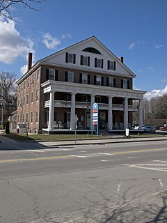
The Windsor House is a historic former hotel building at 54 Main Street in Windsor, Vermont. Built in 1836, it was for many years a mainstay of the village's travel industry, whose famous guests include Theodore Roosevelt. Now converted to other commercial purposes, the building was listed on the National Register of Historic Places in 1971.

The Lind Houses are a series of seven nearly identical houses on Pleasant Street in South Ryegate, Vermont. Built about 1905, they form one of the best-preserved examples of period worker housing in the state. They were listed on the National Register of Historic Places in 1988.

The L'Esperance Historic District, located east of Cruz Bay off Center Line Rd., on Saint Thomas in the U.S. Virgin Islands, is a historic district which was listed on the National Register of Historic Places in 1981. It is located within Virgin Islands National Park. The listing included two contributing structures and nine contributing sites on 6.3 acres (2.5 ha).

Dennis Bay Historic District is a historic district which was listed on the National Register of Historic Places in 1981. It is located northeast of Cruz Bay off North Shore Rd., in Virgin Islands National Park. The plantation was claimed and cleared by 1728 to operate as a sugar cane plantation.


