
The Bernese Alps are a mountain range of the Alps, located in western Switzerland. Although the name suggests that they are located in the Berner Oberland region of the canton of Bern, portions of the Bernese Alps are in the adjacent cantons of Valais, Fribourg and Vaud, the latter being usually named Fribourg Alps and Vaud Alps respectively. The highest mountain in the range, the Finsteraarhorn, is also the highest point in the canton of Bern.

Pinkham's Grant is a township in Coös County, New Hampshire, United States. The grant lies entirely within the White Mountain National Forest. As of the 2020 United States census, the population of the grant was zero.
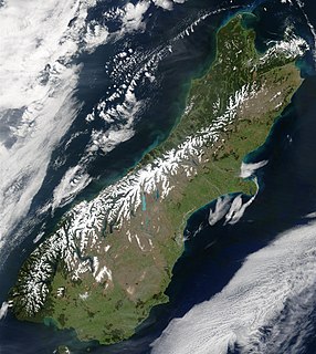
The Southern Alps is a mountain range extending along much of the length of New Zealand's South Island, reaching its greatest elevations near the range's western side. The name "Southern Alps" generally refers to the entire range, although separate names are given to many of the smaller ranges that form part of it.

The Anti-Lebanon Mountains are a southwest–northeast-trending mountain range that forms most of the border between Syria and Lebanon. The border is largely defined along the crest of the range. Most of the range lies in Syria.

The Santa Susana Mountains are a transverse range of mountains in Southern California, north of the city of Los Angeles, in the United States. The range runs east-west, separating the San Fernando Valley and Simi Valley on its south from the Santa Clara River Valley to the north and the Santa Clarita Valley to the northeast. The Oxnard Plain is to the west of the Santa Susana Mountains.

The Transverse Ranges are a group of mountain ranges of southern California, in the Pacific Coast Ranges physiographic region in North America. The Transverse Ranges begin at the southern end of the California Coast Ranges and lie within Santa Barbara, Ventura, Los Angeles, San Bernardino, Riverside and Kern counties. The Peninsular Ranges lie to the south. The name Transverse Ranges is due to their east–west orientation, making them transverse to the general northwest–southeast orientation of most of California's coastal mountains.

The Sangre de Cristo Mountains are the southernmost subrange of the Rocky Mountains. They are located in southern Colorado and northern New Mexico in the United States. The mountains run from Poncha Pass in South-Central Colorado, trending southeast and south, ending at Glorieta Pass, southeast of Santa Fe, New Mexico. The mountains contain a number of fourteen thousand foot peaks in the Colorado portion, as well as all the peaks in New Mexico which are over twelve thousand feet.

Monte Rosa is a mountain massif in the eastern part of the Pennine Alps. It is between Italy's and Switzerland's (Valais). Monte Rosa is the second highest mountain in the Alps and western Europe, after Mont Blanc.

Blue Mountain, Blue Mountain Ridge, or the Blue Mountains of Pennsylvania is a ridge of the Appalachian Mountains in the Lehigh Valley region of eastern Pennsylvania. Forming the southern and eastern edge of the Ridge-and-Valley Appalachians physiographic province in Pennsylvania, Blue Mountain extends 150 miles (240 km) from the Delaware Water Gap on the New Jersey border in the east to Big Gap in Franklin County in south-central Pennsylvania at its southwestern end.

The Pir Panjal Range is a group of mountains in the Lesser Himalayan region, running from east-southeast (ESE) to west-northwest (WNW) across the Indian territories of Himachal Pradesh and Jammu and Kashmir and then Pakistan's Azad Kashmir and Punjab. The average elevation varies from 1,400 m (4,600 ft) to 4,100 m (13,500 ft). The Himalayas show a gradual elevation towards the Dhauladhar and Pir Panjal ranges. Pir Panjal is the largest range of the Lesser Himalayas. Near the bank of the Sutlej River, it dissociates itself from the Himalayas and forms a divide between the Beas and Ravi rivers on one side and the Chenab on the other. The renowned Galyat mountains are also located in this range.

The Annamite Range or the Annamese Mountains is a major mountain range of eastern Indochina, extending approximately 1,100 km (680 mi) through Laos, Vietnam, and a small area in northeast Cambodia. The mountain range is also referred to variously as Annamese Range, Annamese Mountains, Annamese Cordillera, Annamite Mountains and Annamite Cordillera. The name "Annam" is the Vietnamese pronunciation and terminology of Chinese: 安南, meaning "to pacify the south" referring to Vietnam. The French adopted the word and used "Annamese" or "Annamite" to refer to the Vietnamese.
Schunemunk Mountain is the highest mountain in Orange County, New York. The 1,664-foot (507 m) summit is located in the town of Blooming Grove, with other portions in Cornwall and Woodbury. The community of Mountain Lodge Park is built up its western slope.

The Saltoro Mountains are a subrange of the Karakoram Range. They are located in the southeast Karakoram on the southwest side of the Siachen Glacier, one of the two longest glaciers outside the polar regions. The name given to this range is shared with the Saltoro Valley which is located to the west of this range, downslope on the Pakistan side of the Saltoro Range which generally follows the Actual Ground Position Line. Saltoro Kangri peak, Saltoro River, and Saltoro Valley are features on this range. The Actual Ground Position Line (AGPL) between Indian and Pakistan held area runs through this range, where the high peaks and passes of the Siachen area are held by India, whereas Pakistan occupies the lower peaks and valleys to the west.
Piz Kesch (German) or Piz d'Es-cha (Rumantsch) is a peak in the Albula Alps of the Rhaetian Alps in Switzerland. At 3,418 metres (11,214 ft), it is the highest peak in the Albula Alps and the municipality of Bergün, Grisons.

The Allgäu Alps are a mountain range in the Northern Limestone Alps, located in Bavaria and Baden-Württemberg in Germany and Tyrol and Vorarlberg in Austria. The range lies directly east of Lake Constance.

Saltonstall Mountain, also known as Saltonstall Ridge, with a high point of (est.) 320 feet (98 m) above sea level, is a traprock mountain ridge located 3 miles (5 km) east of New Haven, Connecticut and 1.75 miles (2.8 km) north of Long Island Sound. It is part of the Metacomet Ridge that extends from Long Island Sound near New Haven, Connecticut, north through the Connecticut River Valley of Massachusetts to the Vermont border. Saltonstall Mountain is known for its 100 foot (30 m) scenic cliff faces and sharp ridgeline, unique microclimate ecosystems, rare plant communities, and for Lake Saltonstall, a 3 miles (5 km) long by 0.3 miles (400 m) wide municipal reservoir nearly enclosed by the mountain. Saltonstall Mountain is traversed by a number of hiking trails managed by the South Central Connecticut Regional Water Authority (SCCRWA) and Branford Land Trust.
Mission Ridge, also known as Mission Mountain, is a ridge in the Bridge River-Lillooet Country of the South-Central Interior of British Columbia, Canada, extending westward from the town of Lillooet along the north side of Seton Lake to Mission Pass, which is immediately above and to the north of the lakeside community of Shalalth. The road over the pass is also known as Mission Mountain, which is short for "Mission Mountain Road". Mission Creek lies on the north side of the pass, and is a tributary of the Bridge River, the lower reaches of which lie on the north side of the ridge, and which was the only road access into the upper Bridge River Country before the construction of a road through the Bridge River Canyon in the mid-1950s opened that region up to road access from the lower Bridge River valley and the town of Lillooet via the community or Moha. Most, or virtually all, of the ridge, is Indian Reserves, notably Slosh 1, under the administration of the Seton Lake Indian Band, and Bridge River 1, which is under the administration of the Bridge River Indian Band. Parts of the ridge's eastern end are in reserves controlled by the Lillooet Indian Band, including its final spires above Lillooet, which were dubbed St. Mary's Mount by the Reverend Lundin Brown in the 1860s, though that name never stuck and is ungazetted.

The Canelo Hills are a range of low mountains or hills in eastern Santa Cruz County, Arizona. The range consists of a series of northwest–southeast trending ridges extending from the Sonoita Creek valley southwest of Sonoita to the Parker Canyon Lake area in southwest Cochise County, Arizona. The Canelo Hills merge with the Huachuca Mountains to the southeast. The San Rafael Valley lies to the southwest of the range and the Patagonia Mountains lie to the west across the Harshaw Creek valley. The Canelo Hills Cienega Reserve and the ghost town of Canelo, Arizona, are located on the eastern side of the hills.
Indira Col West is a mountain pass at 5,988 metres (19,646 ft)) altitude on the Indira Ridge of Siachen Muztagh in Karakoram Range. It is on the border between Indian-controlled Siachen Glacier and the Chinese-controlled Trans-Karakoram Tract, close to the tripoint of India, Pakistan, and China. The India-Pakistan Actual Ground Position Line (AGPL) in the Siachen area ends near the pass. It is possible to ascend the pass from both the north and south sides controlled by China and India respectively.

The Gitschen is a mountain of the Urner Alps, overlooking Lake Lucerne in the canton of Uri. It lies on the range north of the Surenen Pass, culminating at the Brunnistock.

