Bubaque Airport | |||||||||||
|---|---|---|---|---|---|---|---|---|---|---|---|
 Unpaved runway of Bubaque Airport, Guinea-Bissau | |||||||||||
| Summary | |||||||||||
| Airport type | Public | ||||||||||
| Serves | Bubaque, Guinea-Bissau | ||||||||||
| Elevation AMSL | 80 ft / 24 m | ||||||||||
| Coordinates | 11°18′00″N15°50′20″W / 11.30000°N 15.83889°W | ||||||||||
| Map | |||||||||||
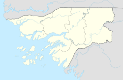 BQE Location of airport in Guinea-Bissau | |||||||||||
 | |||||||||||
| Runways | |||||||||||
| |||||||||||
Bubaque Airport( IATA : BQE, ICAO : GGBU) is an airport serving the island town of Bubaque, in Guinea-Bissau. It is the Bijagos Archipelago's only airfield.
Contents
The airport is on the north end of the island. North approach and departure will be over the water. The 1.2-kilometre (3,900 ft) runway is unpaved.
The airport is located 70 km south of the capital Bissau. It is 22 meters above sea level.
The Bissau VOR-DME (Ident: BIS) is located on the Osvaldo Vieira International Airport at Bissau, 75 kilometres (40 nmi) north-northeast of Bubaque. [3]