Buchbrunn

Last updated
Buchbrunn
Buchbrunn St. Maria Magdalena 003.jpg
Church of Saint Mary Magdalene
DEU Buchbrunn COA.svg
Location of Buchbrunn within Kitzingen district
Buchbrunn in KT.svgCastell
Germany adm location map.svg
Red pog.svg
Buchbrunn
Bavaria location map.svg
Red pog.svg
Buchbrunn
Coordinates: 49°46′N10°08′E / 49.767°N 10.133°E / 49.767; 10.133
Country Germany
State Bavaria
Admin. region Unterfranken
District Kitzingen
Municipal assoc. Kitzingen
Government
   Mayor (202026) Hermann Queck [1]
Area
  Total4.57 km2 (1.76 sq mi)
Elevation
249 m (817 ft)
Population
 (2022-12-31) [2]
  Total1,128
  Density250/km2 (640/sq mi)
Time zone UTC+01:00 (CET)
  Summer (DST) UTC+02:00 (CEST)
Postal codes
97320
Dialling codes 09321
Vehicle registration KT
Website www.buchbrunn.de

Buchbrunn is a municipality in the district of Kitzingen, Lower Franconia, Bavaria, Germany. It is placed in the Bayrische Planungsregion 2.

Contents

History

Several archaeological troves in the boundary of Buchbrunn show that the village which is documented for the first time in 1244 has been a settling area from time immemorial. Among the miscellaneous feudal lords during the 13th and 14th century occur the Lords of Buchbrunn and the Benedictine Sisters' abbey of Kitzingen. Later the Margraves of Ansbach and the Counts of Schwarzenberg possessed important rights on the spot that became Bavarian in 1814. The coat of arms featuring a beech tree (Buche in German) and a well (Brunnen) is based on an old seal of the village court from the 17th century. Today one is even confronted with this symbol for Buchbrunn on the village square, where a beech has been planted alongside the old well. Since 1978 the village is part of the Verwaltungsgemeinschaft Kitzingen and has about 1.000 residents.

Churches

Lutheran

In ab. 1470/80 a new church was built using the romanesque spire of the predecessor chapel. In 1683 the nave was extended and the spire was heightened. Inside one can find an altar crucifix from ab. 1480, a well worked baptismal font furnished with the benefactor's coat of arms and a painting influenced by Lucas Cranach the Elder and Younger which shows a last supper administered by Martin Luther and Philip Melanchthon.

Parish registers

The Lutheran registers start in 1556 and are stored in the Bischöfliche Zentralarchiv in Regensburg.

Catholic

The church Mariä Himmelfahrt was sanctified in 1805. The baroque décor from the time between 1680 and 1780 derives from churches in Würzburg and Kitzingen that were suspended during the Napoleonic period.

Cemetery

In 1611 it was displaced to the outskirts of the village. The ornamented stone lectern from this time is still existing in the middle of the God's acre. The round arch entry portal shows the date 1611 and the crest of Ansbach.

Education

School

The Verbandsschule Buchbrunn , attended by ab. 450 students is an elementary school (grade 1-4) as well as the Hauptschule (grade 5-9) of the Verwaltungsgemeinschaft Kitzingen. It has subsidiaries in Mainstockheim (grade 1-4) and in Kaltensondheim (grade 1-3). Secondary schools of choice are e. g. the Armin-Knab-Gymnasium in Kitzingen, the Richard-Rother Realschule in Kitzingen or Friedrich-Bernbeck-Schule Staatliche Wirtschaftschule in Kitzingen.

Traffic

Railroad line

Buchbrunn is near the railway station Buchbrunn-Mainstockheim (schedule) on the railway line from Nürnberg (1 hour) to Würzburg (15 minutes) which was established in 1865. The old railway station building was torn down in the 1970s. In former times it featured a station restaurant that attracted many promenaders because of the nice outlook it provided on the valley of the river Main. The restaurant building is still standing today and used as a residential house.

Roads

A country road supplemented with a bicycle lane connects Buchbrunn with the city of Kitzingen. The village is as well tangented to the road from Mainstockheim to the Bundesstraße 8 which provides access to Repperndorf and Kitzingen again in the Nürnberg direction and to the Autobahns A7 and A3 as well as to the village of Biebelried in the Würzburg direction. For completion one could as well mention the more or less unofficial shortcuts via concreted field paths to Kitzingen (across the Eselsberg), Mainstockheim (and via this way the city of Dettelbach as well), Repperndorf, Neuhof (hamlet near Biebelried) as well as the Mainfrankenpark.

Sport

The TSV Buchbrunn (official website featuring a detailed chronicle) was founded in 1947 and is best known for its soccer and table tennis teams. It also has compartments for children's gymnastics and others.

Related Research Articles

Kitzingen is a Landkreis (district) in Bavaria, Germany. It is bounded by the districts of Schweinfurt, Bamberg, Neustadt (Aisch)-Bad Windsheim and Würzburg.

Neustadt (Aisch)-Bad Windsheim is a Landkreis (district) in Bavaria, Germany. It is bounded by the districts of Würzburg, Kitzingen, Bamberg, Erlangen-Höchstadt, Fürth and Ansbach, and by the state of Baden-Württemberg.

Würzburg is a Landkreis (district) in the northwestern part of Bavaria, Germany. Neighboring districts are Main-Spessart, Schweinfurt, Kitzingen, Neustadt (Aisch)-Bad Windsheim, and the district Main-Tauber in Baden-Württemberg. The city Würzburg is not part of the district, although it is completely enclosed by it.

<span class="mw-page-title-main">Marktbreit</span> Town in Bavaria, Germany

Marktbreit am Main is a town in the district of Kitzingen in the Regierungsbezirk Unterfranken in Bavaria, Germany. It is situated at the most southern point of the Main river. Marktbreit is the birthplace of Alois Alzheimer who first identified the symptoms of what is now known as Alzheimer's disease. With its suburb Gnodstadt, Marktbreit has around 3,700 inhabitants.

<span class="mw-page-title-main">Königsfeld, Bavaria</span> Municipality in Bavaria, Germany

Königsfeld is a community located in the Upper Franconian district of the Bamberg in Bavaria, and a member of the administrative community (Verwaltungsgemeinschaft) of Steinfeld.

<span class="mw-page-title-main">Mainbernheim</span> Town in Bavaria, Germany

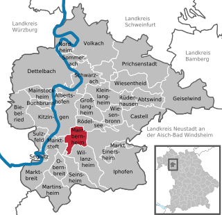
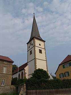
Mainbernheim is a municipality in Bavaria, Germany,4 kilometers to the south of Kitzingen in the direction of Nürnberg. It was first recorded in the chronicles of 889, during the reign of King Arnulf, the church being recognized by the influential bishopric of nearby Würzburg. The town was the site of a tariff house of the dukes of Ansbach and in thrall until 1397 to the duchy in the south, during the reign of King Wenceslaus. Mainbernheim was granted full rights as a city, although taxation privileges for Ansbach were extended until 1795.

<span class="mw-page-title-main">Buchloe</span> Town in Bavaria, Germany

Buchloe is a community raised to town status in 1954, lying in Ostallgäu district in Bavaria. Together with the neighbouring communities of Jengen, Lamerdingen and Waal, Buchloe belongs to the Verwaltungsgemeinschaft of Buchloe.

<span class="mw-page-title-main">Abenberg</span> Town in Bavaria, Germany

Abenberg is a town in the Middle Franconian district of Roth, in Bavaria, Germany. It is situated 9 km west of Roth bei Nürnberg and 25 km southwest of Nuremberg.

<span class="mw-page-title-main">Iphofen</span> Town in Bavaria, Germany

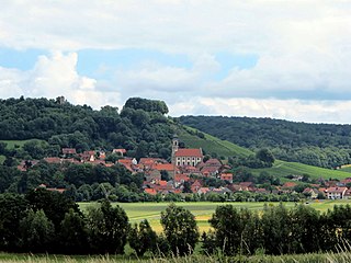
Iphofen is a town in the district of Kitzingen in Bavaria, Germany. It has a population of around 4,500. Iphofen is known for its rare complete medieval town wall and other historic buildings as well as for being a location of wine production.

<span class="mw-page-title-main">Sondheim vor der Rhön</span> Municipality in Bavaria, Germany

Sondheim vor der Rhön is a municipality in the district Rhön-Grabfeld, Bavaria, Germany. It is administrated by the Verwaltungsgemeinschaft Ostheim. As of 2002 it had a population of 1123, and covers an area of 18.58 km2.

<span class="mw-page-title-main">Mespelbrunn</span> Municipality in Bavaria, Germany

Mespelbrunn is a community in the Aschaffenburg district in the Regierungsbezirk of Lower Franconia (Unterfranken) in Bavaria, Germany and a member of the Verwaltungsgemeinschaft of Mespelbrunn, whose seat is in Heimbuchenthal.

<span class="mw-page-title-main">Gerach</span> Municipality in Bavaria, Germany

Gerach is a community in the Upper Franconian district of Bamberg and a member of the administrative community (Verwaltungsgemeinschaft) of Baunach. It lies in the Naturpark Haßberge roughly 20 km north of Bamberg and roughly 10 km south of Ebern.

<span class="mw-page-title-main">Aidhausen</span> Municipality in Bavaria, Germany

Aidhausen is a municipality in the district of Haßberge in Bavaria in Germany, it is a member of the Verwaltungsgemeinschaft Hofheim in Unterfranken.

<span class="mw-page-title-main">Castell, Bavaria</span> Municipality in Bavaria, Germany

Castell is a municipality in the district of Kitzingen in Bavaria in Germany. It was the seat of the Counts of Castell. Today it is part of the municipal association Wiesentheid. It has around 800 inhabitants.

<span class="mw-page-title-main">Aura im Sinngrund</span> Municipality in Bavaria, Germany

Aura im Sinngrund is a community in the Main-Spessart district in the Regierungsbezirk of Lower Franconia (Unterfranken) in Bavaria, Germany and a member of the Verwaltungsgemeinschaft of Burgsinn.

<span class="mw-page-title-main">Gössenheim</span> Municipality in Bavaria, Germany

Gössenheim is a community in the Main-Spessart district in the Regierungsbezirk of Lower Franconia (Unterfranken) in Bavaria, Germany and a member of the Verwaltungsgemeinschaft of Gemünden am Main.

<span class="mw-page-title-main">Mittelsinn</span> Municipality in Bavaria, Germany

Mittelsinn is a municipality in the Main-Spessart district in the Regierungsbezirk of Lower Franconia (Unterfranken) in Bavaria, Germany and a member of the Verwaltungsgemeinschaft of Burgsinn.

<span class="mw-page-title-main">Obersinn</span> Municipality in Bavaria, Germany

Obersinn is a market community in the Main-Spessart district in the Regierungsbezirk of Lower Franconia (Unterfranken) in Bavaria, Germany and a member of the Verwaltungsgemeinschaft of Burgsinn.

<span class="mw-page-title-main">Roden, Bavaria</span> Municipality in Bavaria, Germany

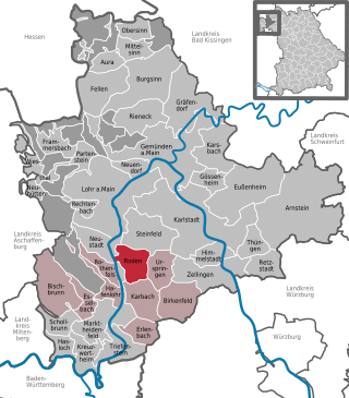
Roden is a community in the Main-Spessart district in the Regierungsbezirk of Lower Franconia (Unterfranken) in Bavaria, Germany and a member of the Verwaltungsgemeinschaft of Marktheidenfeld.

<span class="mw-page-title-main">Erlenbach bei Marktheidenfeld</span> Municipality in Bavaria, Germany

Erlenbach bei Marktheidenfeld is a community in the Main-Spessart district in the Regierungsbezirk of Lower Franconia in Bavaria, Germany and a member of the Verwaltungsgemeinschaft of Marktheidenfeld. It has given itself the title Weinort mit Herz – Wine Town with Heart.

References