
Elko County is a county in the northeastern corner of Nevada, United States. As of the 2020 census, the population was 53,702. Its county seat is Elko. The county was established on March 5, 1869, from Lander County.

The Humboldt–Toiyabe National Forest (HTNF) is the principal U.S. National Forest in the U.S. state of Nevada, and has a smaller portion in Eastern California. With an area of 6,289,821 acres (25,454.00 km2), it is the largest U.S. National Forest outside of Alaska.
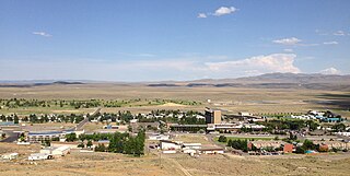
Jackpot is an unincorporated community and census-designated place (CDP) in Elko County, Nevada, United States. The population was 855 as of the 2020 census. Located less than one mile (1.6 km) from the Idaho border on US 93, Jackpot has been a popular casino gaming destination for residents of Idaho and other neighboring states since its founding.
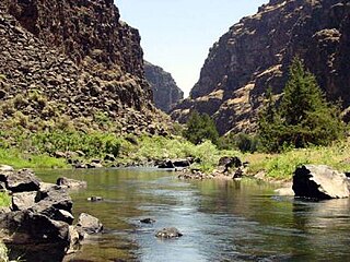
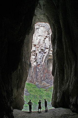
The Bruneau River is a 153-mile-long (246 km) tributary of the Snake River, in the U.S. states of Idaho and Nevada. It runs through a narrow canyon cut into ancient lava flows in southwestern Idaho. The Bruneau Canyon, which is up to 1,200 feet (370 m) deep and 40 miles (64 km) long, features rapids and hot springs, making it a popular whitewater trip.

Jarbidge is an unincorporated community in Elko County, Nevada, United States. Located at the bottom of the Jarbidge River's canyon near the north end of the Jarbidge Mountains, it lies within the Jarbidge Ranger District of the Humboldt-Toiyabe National Forest and is near the northwest edge of the Jarbidge Wilderness, approximately 10 miles (16 km) south of the Idaho–Nevada border.

The Yellowstone hotspot is a volcanic hotspot in the United States responsible for large scale volcanism in Idaho, Montana, Nevada, Oregon, and Wyoming, formed as the North American tectonic plate moved over it. It formed the eastern Snake River Plain through a succession of caldera-forming eruptions. The resulting calderas include the Island Park Caldera, Henry's Fork Caldera, and the Bruneau-Jarbidge caldera. The hotspot currently lies under the Yellowstone Caldera. The hotspot's most recent caldera-forming supereruption, known as the Lava Creek Eruption, took place 640,000 years ago and created the Lava Creek Tuff, and the most recent Yellowstone Caldera. The Yellowstone hotspot is one of a few volcanic hotspots underlying the North American tectonic plate; another example is the Anahim hotspot.

The Jarbidge Wilderness is a wilderness area located in the Jarbidge Mountains of northern Elko County in northeastern Nevada, United States. It is contained within the Jarbidge Ranger District of the Humboldt-Toiyabe National Forest.

The Jarbidge River is a 51.8-mile-long (83.4 km), high elevation river in Elko County, Nevada and Owyhee County, Idaho in the United States. The Jarbidge originates as two main forks in the Jarbidge Mountains of northeastern Nevada and then flows through basalt and rhyolite canyons on the high plateau of the Owyhee Desert before joining the Bruneau River.

The Jarbidge Mountains are a mountain range in northern Elko County, Nevada, United States. The range includes multiple sub-ranges, including the Bruneau Range, Buck Creek Mountains, Copper Mountains, Elk Mountains, Fox Creek Range, Ichabod Range, Marys River Range, Salmon River Range and Wild Horse Range. The central core of the range, including most of the peaks above 10,500 feet (3,200 m), extends southward approximately 5 miles (8 km) from a point near the small community of Jarbidge.

The Northern Basin and Range ecoregion is a Level III ecoregion designated by the United States Environmental Protection Agency (EPA) in the U.S. states of Oregon, Idaho, Nevada, Utah, and California. It contains dissected lava plains, rolling hills, alluvial fans, valleys, and scattered mountain ranges in the northern part of the Great Basin. Although arid, the ecoregion is higher and cooler than the Snake River Plain to the north and has more available moisture and a cooler climate than the Central Basin and Range to the south. Its southern boundary is determined by the highest shoreline of Pleistocene Lake Bonneville, which once inundated the Central Basin and Range. The western part of the region is internally drained; its eastern stream network drains to the Snake River system.

The Fox Creek Range is a mountain range in Elko County, Nevada, United States. It is mostly contained within the Jarbidge Ranger District of the Humboldt-Toiyabe National Forest. The range is considered to be a sub-range of the Jarbidge Mountains.

The Copper Mountains are a mountain range in Elko County, Nevada, United States.

The Murphy Complex Fire was a 2007 wildfire that included acreage upon the Bureau of Land Management (BLM) Bruneau and Jarbidge Field Offices of Idaho, BLM Elko Field Office of Nevada, and Forest Service Mountain City and Jarbidge Districts of Nevada. It burned an estimated 652,016 acres (263,862 ha) of land. By acreage, it was the third largest wildfire in the United States between 1997 and 2009. The fire affected Owyhee and Twin Falls counties in Idaho, and Elko County, Nevada. Nearly three times as much acreage burned in the two Idaho counties as burned in Nevada. Aerial crews were primarily responsible for fighting the fire in Castleford, Idaho. About 560 wildfire firefighters were involved including a Type 1 team that specializes in fighting large wildfires. This was the third large fire in as many years on land managed by the Jarbidge Field Office in Idaho's Twin Falls District. Because of this, the BLM held a workshop on large wildfires in the district on May 12–14, 2009.
The Bruneau – Jarbidge Rivers Wilderness is located on the high basalt plateaus of Owyhee County in southwestern Idaho in the western United States. The wilderness area is named after and protects much of the Bruneau and Jarbidge Rivers and their canyons. Whitewater rafting is a popular recreational activity in this wilderness area, which has rivers up to Class V. About 40 miles (64 km) of the Bruneau River and about 28.8 miles (46.3 km) of the Jarbidge River are classified as a wild river.

Salmon Falls Creek is a tributary of the Snake River, flowing from northern Nevada into Idaho in the United States. Formed in high mountains at the northern edge of the Great Basin, Salmon Falls Creek flows northwards 121 miles (195 km), draining an arid and mountainous basin of 2,103 square miles (5,450 km2). The Salmon Falls Creek valley served as a trade route between the Native American groups of the Snake River Plain and Great Basin. Today, most of its water is used for irrigation.

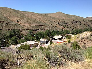
Charleston is a ghost town in Elko County, Nevada, United States. It lies along the Bruneau River just south of the Mountain City and Jarbidge Ranger Districts of the Humboldt-Toiyabe National Forest and is near the southwest edge of the Jarbidge Wilderness.

Sheep Creek is a 63-mile (101 km) long tributary of the Bruneau River. Beginning at an elevation of 6,126 feet (1,867 m) east of Owyhee in northern Elko County, Nevada, it flows generally north into Owyhee County, Idaho and the Owyhee Desert, where it is roughly paralleled by Idaho State Highway 51. It then flows to its mouth in the Bruneau – Jarbidge Rivers Wilderness, at an elevation of 3,415 feet (1,041 m). In 2009, 25.6 miles (41.2 km) of the creek were designated as wild by the Omnibus Public Land Management Act, which also created the Bruneau – Jarbidge Rivers Wilderness.
Copper Basin is a basin located between the Copper Mountains and Fox Creek Range of northern Elko County, Nevada, United States. The basin, located on the border of the Mountain City and Jarbidge ranger districts within the Humboldt-Toiyabe National Forest, is known for its displays of wildflowers during early summer. It is accessed via Elko County Route 748, also known as Charleston-Jarbidge Road, by way of either Charleston or Jarbidge.
Murphy Hot Springs is an unincorporated community in Owyhee County, Idaho, United States.
