Buckner, Kentucky

Last updated

Buckner, Kentucky
CDP
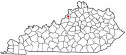
KYMap-doton-Buckner.PNG
Location of Buckner, Kentucky
Coordinates: 38°23′25″N85°27′13″W / 38.39028°N 85.45361°W / 38.39028; -85.45361
Country United States
State Kentucky
County Oldham
Area
[1]
  Total8.82 sq mi (22.83 km2)
  Land8.64 sq mi (22.37 km2)
  Water0.18 sq mi (0.46 km2)
Elevation
[2]
761 ft (232 m)
Population
 (2020)
  Total5,785
  Density669.72/sq mi (258.59/km2)
Time zone UTC-5 (Eastern (EST))
  Summer (DST) UTC-4 (EDT)
ZIP code
40010
Area code 502
FIPS code 21-10648
GNIS feature ID2402727 [2]

Buckner is a census-designated place (CDP) in Oldham County, Kentucky, United States. The population was 4,000 at the 2000 census.

Contents

Oldham County High School is located in Buckner.

Geography

According to the United States Census Bureau, the CDP has a total area of 7.5 square miles (19 km2), of which 7.4 square miles (19 km2) is land and 0.2 square miles (0.52 km2) (2.00%) is water.

Demographics

Historical population
CensusPop.Note
2000 4,000
2020 5,785
U.S. Decennial Census [3]

As of the census [4] of 2000, there were 4,000 people, 580 households, and 512 families residing in the CDP. The population density was 543.8 inhabitants per square mile (210.0/km2). There were 597 housing units at an average density of 81.2 per square mile (31.4/km2). The racial makeup of the CDP was 80.75% White, 18.25% African American, 0.07% Native American, 0.25% Asian, 0.38% from other races, and 0.30% from two or more races. Hispanic or Latino of any race were 0.72% of the population.

There were 580 households, out of which 49.5% had children under the age of 18 living with them, 80.5% were married couples living together, 5.9% had a female householder with no husband present, and 11.7% were non-families. 9.5% of all households were made up of individuals, and 2.9% had someone living alone who was 65 years of age or older. The average household size was 3.07 and the average family size was 3.28.

In the CDP, the population was spread out, with 14.3% under the age of 18, 12.5% from 18 to 24, 46.0% from 25 to 44, 23.8% from 45 to 64, and 3.5% who were 65 years of age or older. The median age was 36 years. For every 100 females, there were 349.4 males. For every 100 females age 18 and over, there were 461.0 males.

The median income for a household in the CDP was $81,548, and the median income for a family was $83,323. Males had a median income of $50,395 versus $31,484 for females. The per capita income for the CDP was $15,867. About 1.9% of families and 1.7% of the population were below the poverty line, including none of those under age 18 and 24.3% of those age 65 or over.

Related Research Articles

<span class="mw-page-title-main">Brickerville, Pennsylvania</span> Census-designated place in Pennsylvania, United States

Brickerville is an unincorporated community and census-designated place (CDP) in Elizabeth Township, Lancaster County, Pennsylvania, United States, with a ZIP code of 17543. The population was 1,309 at the 2010 census.

<span class="mw-page-title-main">Forestdale, Alabama</span> Unincorporated community in Alabama, United States

Forestdale is an unincorporated community and census-designated place (CDP) in Jefferson County, Alabama, United States. It is north of the Birmingham city neighborhood of Ensley. At the 2020 census, the population was 10,409.

<span class="mw-page-title-main">Moores Mill, Alabama</span> Census-designated place in Alabama, United States

Moores Mill is an unincorporated community and census-designated place (CDP) in Madison County, Alabama, United States, and is included in the Huntsville-Decatur Combined Statistical Area. The population was 6,729 at the 2020 census, up from 5,682 at the 2010 census.

<span class="mw-page-title-main">Bayview-Montalvin, California</span> Former CDP in California, United States

Bayview-Montalvin is a former census-designated place (CDP) in Contra Costa County, California, United States. The population was 5,004 at the 2000 census.

<span class="mw-page-title-main">Parkwood, California</span> Census-designated place in California, United States

Parkwood is a census-designated place (CDP) in Madera County, California, United States. It is part of the Madera Metropolitan Statistical Area. The population was 2,307 at the 2020 census.

<span class="mw-page-title-main">Crestline, California</span> Census-designated place in California, United States

Crestline is a census-designated place in the San Bernardino Mountains of San Bernardino County, California, USA. The population was 10,770 at the 2010 census, up from 10,218 at the 2000 census.

<span class="mw-page-title-main">Kennedy, California</span> Census-designated place in California, United States

Kennedy is a census-designated place (CDP) in San Joaquin County, California, United States. The population was 3,356, at the 2020 census, up from 3,254 at the 2000 census.

<span class="mw-page-title-main">Park View, Iowa</span> CDP in Iowa, USA

Park View is a census-designated place (CDP) in Scott County, Iowa, United States. The population was 2,709 at the time of the 2020 census; up from 2,389 at the 2010 census.

<span class="mw-page-title-main">Naval Academy, Maryland</span> Census-designated place in Maryland, United States

Naval Academy is a census-designated place (CDP) in Anne Arundel County, Maryland, United States, which covers the campus of the United States Naval Academy. The population was 4,802 at the 2010 census.

<span class="mw-page-title-main">White Earth, Minnesota</span> Census-designated place in Minnesota, United States

White Earth is a census-designated place (CDP) in Becker County, Minnesota, United States. The population was 580 at the 2010 census.

<span class="mw-page-title-main">Nellieburg, Mississippi</span> Census-designated place in Mississippi, United States

Nellieburg is an unincorporated community and census-designated place (CDP) in Lauderdale County, Mississippi, United States. The population was 1,316 at the 2020 census. It is a suburb of Meridian.

<span class="mw-page-title-main">Yah-ta-hey, New Mexico</span> CDP in New Mexico, United States

Yah-ta-hey is a census-designated place (CDP) in McKinley County, New Mexico, United States. As of the 2000 census, the CDP population was 580. The English name for this place is an approximation of a Navajo greeting, though the actual Navajo name means "like a devil", in reference to J.B. Tanner, who operated the trading post located here; the same name is used for Aneth, Utah, where Tanner also worked.

<span class="mw-page-title-main">Sherwood, Hamilton County, Ohio</span> Census-designated place in Ohio, United States

Sherwood is a census-designated place (CDP) in Hamilton County, Ohio, United States. The population was 3,633 at the 2020 census.

Flint Creek is an unincorporated area and census-designated place (CDP) in Delaware County, Oklahoma, United States. The population was 732 at the 2010 census, up from 580 in 2000.

<span class="mw-page-title-main">Monarch Mill, South Carolina</span> CDP in South Carolina, United States

Monarch Mill is a census-designated place (CDP) in Union County, South Carolina, United States. The population was 1,811 at the 2010 census.

<span class="mw-page-title-main">Serenada, Texas</span> CDP in Texas, United States

Serenada is a census-designated place (CDP) in Williamson County, Texas, United States. The population was 2,098 at the 2020 census. Those living in Serenada have Georgetown addresses.

<span class="mw-page-title-main">Lyndhurst, Virginia</span> CDP in Virginia, United States

Lyndhurst is a census-designated place (CDP) in Augusta County, Virginia, United States. The population was 1,490 at the 2010 census. It is part of the Staunton–Waynesboro Micropolitan Statistical Area.

<span class="mw-page-title-main">Verlot, Washington</span> CDP in Washington, United States

Verlot is a census-designated place (CDP) in Snohomish County, Washington, United States. The population was 285 at the 2010 census.

<span class="mw-page-title-main">Loveland Park, Ohio</span> Census-designated place in Ohio, United States

Loveland Park is a census-designated place (CDP) located in Symmes Township, Hamilton County and Deerfield Township, Warren County, in the southwestern part of the U.S. state of Ohio. The CDP is named after the city of Loveland. The population was 1,737 at the 2020 census.

<span class="mw-page-title-main">Westerly (CDP), Rhode Island</span> CDP in Rhode Island, United States

Westerly is a census-designated place (CDP) in the town of Westerly in Washington County, Rhode Island, United States. The population was 17,682 at the 2000 census. The CDP includes the majority of the town of Westerly's population, with only the rural eastern and coastal southern portions of towns excluded.

References

  1. "2020 U.S. Gazetteer Files". United States Census Bureau. Retrieved March 18, 2022.
  2. 1 2 U.S. Geological Survey Geographic Names Information System: Buckner, Kentucky
  3. "Census of Population and Housing". Census.gov. Retrieved June 4, 2016.
  4. "U.S. Census website". United States Census Bureau . Retrieved January 31, 2008.