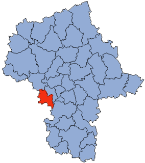
Gmina Puszcza Mariańska is a rural gmina in Żyrardów County, Masovian Voivodeship, in east-central Poland. Its seat is the village of Puszcza Mariańska, which lies approximately 10 kilometres (6 mi) south-west of Żyrardów and 52 km (32 mi) south-west of Warsaw.

Adamówek is a village in the administrative district of Gmina Mszczonów, within Żyrardów County, Masovian Voivodeship, in east-central Poland. It lies approximately 5 kilometres (3 mi) south of Mszczonów, 15 km (9 mi) south-east of Żyrardów, and 45 km (28 mi) south-west of Warsaw.
Badów Górny is a village in the administrative district of Gmina Mszczonów, within Żyrardów County, Masovian Voivodeship, in east-central Poland. It lies approximately 3 kilometres (2 mi) south of Mszczonów, 14 km (9 mi) south-east of Żyrardów, and 44 km (27 mi) south-west of Warsaw.
Wręcza is a village in the administrative district of Gmina Mszczonów, within Żyrardów County, Masovian Voivodeship, in east-central Poland. It lies approximately 6 kilometres (4 mi) north-west of Mszczonów, 6 km (4 mi) south of Żyrardów, and 44 km (27 mi) south-west of Warsaw.
Budy Zaklasztorne is a village in the administrative district of Gmina Puszcza Mariańska, within Żyrardów County, Masovian Voivodeship, in east-central Poland. It lies approximately 3 kilometres (2 mi) north-west of Puszcza Mariańska, 10 km (6 mi) south-west of Żyrardów, and 53 km (33 mi) south-west of Warsaw.

Radziwiłłów is a village in the administrative district of Gmina Puszcza Mariańska, within Żyrardów County, Masovian Voivodeship, in east-central Poland. It lies approximately 5 kilometres (3 mi) west of Puszcza Mariańska, 12 km (7 mi) south-west of Żyrardów, and 55 km (34 mi) south-west of Warsaw.
Adamów is a village in the administrative district of Gmina Radziejowice, within Żyrardów County, Masovian Voivodeship, in east-central Poland. It lies approximately 3 kilometres (2 mi) north-east of Radziejowice, 10 km (6 mi) east of Żyrardów, and 38 km (24 mi) south-west of Warsaw.
Adamów-Parcel is a village in the administrative district of Gmina Radziejowice, within Żyrardów County, Masovian Voivodeship, in east-central Poland. It lies approximately 3 kilometres (2 mi) north-east of Radziejowice, 11 km (7 mi) east of Żyrardów, and 37 km (23 mi) south-west of Warsaw.
Benenard is a village in the administrative district of Gmina Radziejowice, within Żyrardów County, Masovian Voivodeship, in east-central Poland. It lies approximately 9 kilometres (6 mi) west of Radziejowice, 4 km (2 mi) south of Żyrardów, and 45 km (28 mi) south-west of Warsaw.
Budy Józefowskie is a village in the administrative district of Gmina Radziejowice, within Żyrardów County, Masovian Voivodeship, in east-central Poland. It lies approximately 6 kilometres (4 mi) north of Radziejowice, 11 km (7 mi) east of Żyrardów, and 34 km (21 mi) south-west of Warsaw.
Chroboty is a village in the administrative district of Gmina Radziejowice, within Żyrardów County, Masovian Voivodeship, in east-central Poland. It lies approximately 8 kilometres (5 mi) north-west of Radziejowice, 3 km (2 mi) east of Żyrardów, and 41 km (25 mi) south-west of Warsaw.
Korytów is a village in the administrative district of Gmina Radziejowice, within Żyrardów County, Masovian Voivodeship, in east-central Poland. It lies approximately 6 kilometres (4 mi) north-west of Radziejowice, 4 km (2 mi) south-east of Żyrardów, and 41 km (25 mi) south-west of Warsaw.
Krze Duże is a village in the administrative district of Gmina Radziejowice, within Żyrardów County, Masovian Voivodeship, in east-central Poland. It lies approximately 4 kilometres (2 mi) east of Radziejowice, 13 km (8 mi) south-east of Żyrardów, and 37 km (23 mi) south-west of Warsaw.
Radziejowice is a village in Żyrardów County, Masovian Voivodeship, in east-central Poland. It is the seat of the gmina called Gmina Radziejowice. It lies approximately 10 kilometres (6 mi) south-east of Żyrardów and 40 km (25 mi) south-west of Warsaw.
Słabomierz is a village in the administrative district of Gmina Radziejowice, within Żyrardów County, Masovian Voivodeship, in east-central Poland. It lies approximately 4 kilometres (2 mi) west of Radziejowice, 8 km (5 mi) south-east of Żyrardów, and 42 km (26 mi) south-west of Warsaw.
Zboiska is a village in the administrative district of Gmina Radziejowice, within Żyrardów County, Masovian Voivodeship, in east-central Poland. It lies approximately 3 kilometres (2 mi) south-east of Radziejowice, 13 km (8 mi) south-east of Żyrardów, and 39 km (24 mi) south-west of Warsaw.
Jesionka is a village in the administrative district of Gmina Wiskitki, within Żyrardów County, Masovian Voivodeship, in east-central Poland. It lies approximately 9 kilometres (6 mi) south-west of Wiskitki, 7 km (4 mi) south-west of Żyrardów, and 50 km (31 mi) south-west of Warsaw.
Smolarnia is a village in the administrative district of Gmina Wiskitki, within Żyrardów County, Masovian Voivodeship, in east-central Poland. It lies approximately 9 kilometres (6 mi) south-west of Wiskitki, 10 km (6 mi) west of Żyrardów, and 52 km (32 mi) south-west of Warsaw.
Tomaszew is a village in the administrative district of Gmina Wiskitki, within Żyrardów County, Masovian Voivodeship, in east-central Poland. It lies approximately 5 kilometres (3 mi) south-west of Wiskitki, 5 km (3 mi) west of Żyrardów, and 48 km (30 mi) south-west of Warsaw.