Related Research Articles

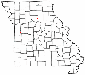
Montgomery City is a city in and the county seat of Montgomery County, Missouri, United States. The population was 2,811 at the 2020 census.

Rocky Comfort is an unincorporated community and census-designated place in northeastern McDonald County, Missouri, United States, on Route 76. It is part of the Fayetteville–Springdale–Rogers, AR-MO Metropolitan Statistical Area.

Grovespring is an unincorporated community in Wright County, Missouri, United States. It is located on Missouri Route 5, approximately 20 miles (32 km) south of Lebanon, Missouri in neighbouring Laclede County.
Montier is a census-designated place in southwestern Shannon County, Missouri, United States. As of the 2020 census, the population was 49.
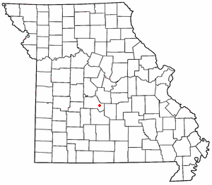
Montreal is an unincorporated community in southeast Camden County, Missouri, United States. It is located approximately eight miles east-southeast of Camdenton and 12 miles northwest of Richland on Route 7.
Dawn is an unincorporated community and census-designated place (CDP) in Livingston County, Missouri, United States. As of the 2020 census it had a population of 100.
Ravanna is a census-designated place in Mercer County, Missouri, United States. It is located approximately seven miles northeast of Princeton on U.S. Route 136. The population was 60 at the 2020 census.
Mineola is an unincorporated community in western Montgomery County, Missouri, United States. The community is located on Missouri Supplemental Route J and is about one mile south from Interstate 70. Montgomery City is approximately six miles north of the community. It is on the east bank of the Loutre River. Graham Cave within Graham Cave State Park is on the north side of I-70 just north of the community and Mount Horeb Baptist Church is approximately 4.5 miles to the southwest.
Deering is an unincorporated community in Pemiscot County, Missouri, United States. It is located fifteen miles west of Caruthersville.

Hollywood is an unincorporated community in southern Dunklin County, Missouri, United States. It is located less than one mile from Route 164, approximately twelve miles south of Kennett.
Bluffton is an unincorporated community in western Montgomery County, Missouri, United States. It is located on Route 94, approximately ten miles west of Hermann, near the Missouri River.
Prairie Hill is an unincorporated community in eastern Chariton County, Missouri, United States. The community is located at the intersection of Missouri routes W and HH approximately seven miles north-northeast of Salisbury. The Thomas Hill Reservoir dam is seven miles to the northeast in adjacent Randolph County.
Conception is a census-designated place in eastern Nodaway County, Missouri, United States. It is located about 11 mi (18 km) southeast of Maryville on U.S. Route 136. It is very near Conception Junction. Conception is home to Conception Abbey.
Prices Branch is an unincorporated community in Montgomery County, Missouri, United States. The community is located on State Highway JJ and Price's Branch Road and is approximately 13.4 miles (21.6 km) east of Montgomery City.
New Market is a census designated place in northern Platte County, in the U.S. state of Missouri. It lies within the Kansas City metropolitan area. The population was 88 at the 2020 census.
Aurora Springs is an unincorporated community and census-designated place in northern Miller County, in the U.S. state of Missouri. The community is located on Saline Creek, just south of Eldon and west of U.S. Route 54.
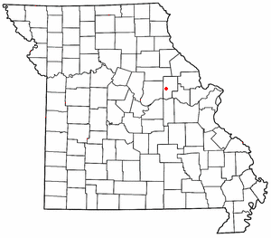
Big Spring is a census-designated places in Montgomery County, in the U.S. state of Missouri.
Coon Creek is a stream in Audrain and Montgomery counties in the U.S. state of Missouri. It is a tributary of the West Fork Cuivre River.
Danville is an unincorporated, small, rural village in Montgomery County, in the U.S. state of Missouri. It is located just off Interstate 70 at a marked turnoff. There is a combined gas station-food store-lunch counter-florist shop just off the interstate, an automotive repair shop in the village, and a quarry operation just outside it; and no other businesses or services.
Elkhorn Creek is a stream in Montgomery County in the U.S. state of Missouri. It is a tributary of the West Fork of the Cuivre River.
References
- 1 2 3 U.S. Geological Survey Geographic Names Information System: Buell, Missouri
- ↑ "ArcGIS REST Services Directory". United States Census Bureau. Retrieved September 5, 2022.
- ↑ U.S. Geological Survey Geographic Names Information System: Buell, Missouri
- ↑ "Montgomery County Place Names, 1928–1945". The State Historical Society of Missouri. Archived from the original on June 24, 2016. Retrieved November 11, 2016.
- ↑ "Post Offices". Jim Forte Postal History. Retrieved November 11, 2016.
- ↑ "Census of Population and Housing". Census.gov. Retrieved June 4, 2016.
Municipalities and communities of Montgomery County, Missouri, United States | ||
|---|---|---|
| Cities |  | |
| Village | ||
| Townships | ||
| CDPs | ||
| Other communities | ||
| | This Montgomery County, Missouri state location article is a stub. You can help Wikipedia by expanding it. |