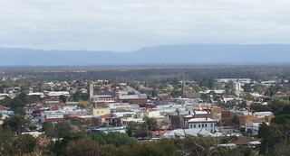
Ballarat is a city in the Central Highlands of Victoria, Australia. At the 2021 Census, Ballarat had a population of 116,201, making it the third largest city in Victoria.

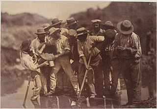
The Eureka Rebellion was a series of events involving gold miners who revolted against the British administration of the colony of Victoria, Australia during the Victorian gold rush. It culminated in the Battle of the Eureka Stockade, which took place on 3 December 1854 at Ballarat between the rebels and the colonial forces of Australia. The fighting resulted in an official total of 27 deaths and many injuries, the majority of casualties being rebels. There was a preceding period beginning in 1851 of peaceful demonstrations and civil disobedience on the Victorian goldfields. The miners had various grievances, chiefly the cost of mining permits and the officious way the system was enforced.

The Victorian gold rush was a period in the history of Victoria, Australia approximately between 1851 and the late 1860s. It led to a period of extreme prosperity for the Australian colony, and an influx of population growth and financial capital for Melbourne, which was dubbed "Marvellous Melbourne" as a result of the procurement of wealth.

Stawell, is an Australian town in the Wimmera region of Victoria 237 kilometres (147 mi) west-north-west of the state capital, Melbourne. Located within the Shire of Northern Grampians local government area, it is a seat of local government for the shire and its main administrative centre. At the 2021 census, Stawell had a population of 6,220.

The Eureka Flag was flown at the Battle of the Eureka Stockade, which took place on 3 December 1854 at Ballarat in Victoria, Australia. It was the culmination of the 1851–1854 Eureka Rebellion on the Victorian goldfields, where miners protested against the cost of mining permits and the officious way the colonial authorities enforced the system along with other grievances. An estimated crowd of over 10,000 demonstrators swore allegiance to the flag as a symbol of defiance at Bakery Hill on 29 November 1854. It was then flown over the Eureka Stockade during the battle which left an official total of 27 deaths. Around 120 miners were arrested, and many others were badly wounded.

The Courier-Mail is an Australian newspaper published in Brisbane. Owned by News Corp Australia, it is published daily from Monday to Saturday in tabloid format. Its editorial offices are located at Bowen Hills, in Brisbane's inner northern suburbs, and it is printed at Murarrie, in Brisbane's eastern suburbs. It is available for purchase throughout Queensland, most regions of Northern New South Wales and parts of the Northern Territory.

Clunes is a town in Victoria, Australia, 36 kilometres north of Ballarat, in the Shire of Hepburn. At the 2016 census it had a population of 1,728.

Creswick is a town in west-central Victoria, Australia, 18 kilometres north of Ballarat and 122 kilometres northwest of Melbourne, in the Shire of Hepburn. It is 430 metres above sea level. At the 2016 census, Creswick had a population of 3,170. Creswick was named after the Creswick family, the pioneer settlers of the region.

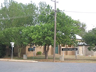
Mangoplah is a town approximately 36 kilometres (22 mi) south of Wagga Wagga in the Riverina region of New South Wales, Australia. At the 2016 census, Mangoplah had a population of 309. The name of the town is believed to mean "Kooris singing" in the Wiradjuri aboriginal language.

Black Hill is a suburb of Ballarat, Victoria, Australia in the northeast of the city. It is named after the major landmark, Black Hill, on which there was extensive and highly profitable open-cut gold mining from the early 1850s during the Victoria gold rush. The hill was originally given its indigenous name, Bowdun, by surveyor William Urquhart.

Graniteville is a small, unincorporated community and census-designated place (CDP) located in Nevada County, California, United States. The town sits on the San Juan ridge separating the Middle and South Forks of the Yuba River, approximately 26 miles (42 km) northeast of Nevada City. The elevation of Graniteville is 4,977 feet (1,517 m) above sea level.
Lake City is an unincorporated community in Nevada County, California. It lies at an elevation of 3300 ft. about 10 miles northeast of Nevada City as the crow flies, and about three miles southeast of North Columbia, and three miles southwest of North Bloomfield. It is located at the junction of modern day North Bloomfield, Back Bone and Lake City Roads. It was an important mining and transportation center in the second half of the 19th century.

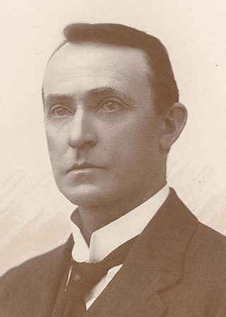
David John O'Keefe was an Australian politician and journalist. He was a member of the Australian Labor Party (ALP) and served in both houses of federal parliament, as a Senator for Tasmania and holding the House of Representatives (1922–1925). He subsequently entered state parliament, serving as Speaker of the Tasmanian House of Assembly (1934–1942). Prior to entering politics he had been the editor of the Zeehan and Dundas Herald on Tasmania's west coast.

Bakery Hill is an inner city suburb of Ballarat in Victoria, Australia. It is the smallest suburb in the city of Ballarat in terms of both area and population, which at the 2021 census was just 180 people. The area is a mix of residential and commercial, as it has been since it came into existence at the beginning of the gold rush. In the present time it is mainly known for its restaurants and pubs, as well as fast food. The suburb boundaries are that of Mair, East, Barkly, Steinfield and Peel Streets.

During the Australian gold rushes, starting in 1851, significant numbers of workers moved from elsewhere in Australia and overseas to where gold had been discovered. Gold had been found several times before, but the colonial government of New South Wales had suppressed the news out of the fear that it would reduce the workforce and destabilise the economy.
The Ballarat Star was a newspaper in Ballarat, Victoria, Australia, first published on 22 September 1855. Its publication ended on 13 September 1924 when it was merged with its competitor, the Ballarat Courier.

Eyres House is an historic residential property, located at 810 Ligar Street Soldiers Hill in the Victorian gold rush city of Ballarat, Victoria, Australia. Later named Balmoral, the house was constructed between 1901 and 1905 for Joseph Bryant, and having passed through as series of private hands, is now under the ownership of the Ballarat Health Services for use as a day centre and intermittent residential service for people with memory loss and confusion.

Bald Hills is a locality in central Victoria, Australia, in the Hepburn Shire local government area, 107 kilometres (66 mi) west of the state capital, Melbourne, and 14 kilometres (8.7 mi) north of Ballarat. The area is about 442 metres (1,450 ft) above sea level.
William Garnet South was a police officer in Alice Springs and Chief Protector of Aborigines. He was also, for a short period, proprietor of the Stuart Arms Hotel in Alice Springs.
Cunningar is a locality in the Hilltops Council local government area, within the South West Slopes region of New South Wales, Australia. It is located immediately to the east of the town of Harden. There is a parish of the County of Harden of the same name, which comprises a part of the area of the locality.


