Bullet Tree Falls

Last updated
Bullet Tree Falls
May 2017 Bullet Tree Falls aerial 17b.jpg
Aerial view of the main road in Bullet Tree Falls
Belize location map.svg
Red pog.svg
Bullet Tree Falls
Coordinates: 17°10′05″N89°06′40″W / 17.168°N 89.111°W / 17.168; -89.111
Country Flag of Belize.svg  Belize
District Cayo District
Constituency Cayo North
Elevation
69 m (226 ft)
Population
 (2010)
  Total2,124 [1]
Time zone UTC-6 (Central)
Climate Am

Bullet Tree Falls is a village located along the Mopan River in Cayo District, Belize. It lies approximately five kilometers (three miles) northwest of San Ignacio. [2] [3] According to the 2010 census, Bullet Tree Falls has a population of 2,124 people in 426 households. [1] The population consists mainly of Spanish-speaking mestizos, along with a smaller number of Maya and Creoles. [2] [3] [4]

Contents

Bullet Tree Falls
Bullet Tree Falls

Demographics

At the time of the 2010 census, Bullet Tree Falls had a population of 2,124. Of these, 91.0% were Mestizo, 3.4% Mixed, 1.1% Creole, 1.0% Yucatec Maya, 0.9% Caucasian, 0.8% Mopan Maya, 0.7% Ketchi Maya, 0.3% East Indian and 0.1% Mennonite. [5]

Government

Bullet Tree Falls is governed by a seven-person village council. As of 2019, the chairperson of the council is Thai Wu. [6]

History

Bullet Tree Falls was first established as a small logging camp in the 1800s. [7] During the Caste War of Yucatán, many Maya families migrated to Bullet Tree Falls from villages further north such as El Chorro and Yaloch. [2] [7] By 1917, there were approximately one hundred and forty people living in the village in twenty-three households. [7] During the early and mid 20th century, an influx of mestizos migrated to the village from Guatemala and Mexico, many of them working as chicleros. [4] [7] During the early days of the chicle and timber industries in Belize, the village was an important trading post. [8]

The first Creoles settled in Bullet Tree Falls in the 1950s, arriving from San Ignacio. [9] In 1961, Hurricane Hattie caused significant damage to the village, destroying a school building and church. [7] [10] During the 1960s and 1970s, several Mopan Maya families moved to Bullet Tree Falls from the Toledo District. [7] By 1970, the population of the village had grown to approximately 700. [7] In 1988, the Salvador Fernandez Bridge was completed, replacing an older wooden bridge. [10]

Attractions

Tubing down the Mopan River is a popular tourist activity in Bullet Tree Falls. Tubing down the Mopan river in Bullet Tree Falls.JPG
Tubing down the Mopan River is a popular tourist activity in Bullet Tree Falls.

Bullet Tree Falls has developed a small tourist economy facilitated by its location between San Ignacio and the El Pilar Maya archeological site. [2] The village hosts several lodges and a small botanical garden. [11] Buses between Bullet Tree Falls and San Ignacio run several times a day and taxi service is available to San Ignacio and El Pilar. [11]

Related Research Articles

<span class="mw-page-title-main">Demographics of Belize</span> Demographics of country

Demographics of the population of Belize include population density, ethnicity, education level, health of the populace, economic status, religious affiliations and other aspects.

<span class="mw-page-title-main">Benque Viejo del Carmen</span> Town in Cayo District, Belize

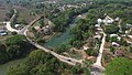
Benque Viejo del Carmen ("Benque") is the westernmost town in Belize, 130 km (81 mi) by road west and south of Belize City, at the Guatemalan border. San Ignacio lies 13 km to the east and Melchor de Mencos just across the border. The Mopan River runs along the town's north and west edges.

<span class="mw-page-title-main">Cayo District</span> District of Belize

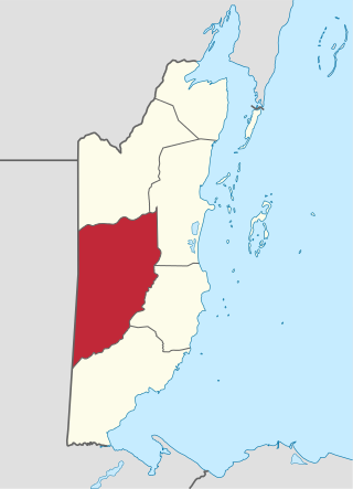
Cayo District is a district located in the west part of Belize. It is the most extensive, second-most populous and third-most densely populated of the six districts of Belize. The district's capital is the town of San Ignacio.

<span class="mw-page-title-main">San Ignacio, Belize</span> Town in Cayo, Belize

San Ignacio and Santa Elena are towns in western Belize. San Ignacio serves as the cultural-economic hub of Cayo District. It got its start from mahogany and chicle production during British colonisation. Over time it attracted people from the surrounding areas, which led to the diverse population of the town today. San Ignacio is the largest settlement in Cayo District and the second largest in the country, after Belize City.

<span class="mw-page-title-main">Spanish Lookout</span> Place in Cayo District, Belize

Spanish Lookout is a settlement in the Cayo District of Belize in Central America. According to the 2010 census, Spanish Lookout had a population of 2,253 people in 482 households. Spanish Lookout is a community of Mennonites.

Roaring Creek is a small village in the Cayo District of Belize, just north-west of Belmopan. Its name is derived from the creek waterfalls which flow into the Belize River next to the Guanacaste Park area.

Armenia is a village in the Cayo District of Belize, along the nation's Hummingbird Highway south of the capitol, Belmopan.

Blackman Eddy is a village located on the banks of the Belize River in the Cayo District, Belize. The George Price Highway runs through the middle of the village.

La Democracia is a populated settlement located in the nation of Belize. It is a mainland village that is located in Belize District.

<span class="mw-page-title-main">Hispanic and Latin American Belizean</span>

Hispanic and Latin American Belizeans are Belizeans of full or partial Hispanic and Latin American descent. Currently, they comprise around 52.9% of Belize's population.

<span class="mw-page-title-main">San Antonio, Toledo</span> Place in Toledo, Belize

San Antonio is a village in the Toledo District of Belize. It is the largest Maya settlement in Belize, with a population of approximately 1,000 people, predominantly Mopan Maya. About 88% of the inhabitants are Catholic, with 8% belonging to other Christian denominations, and 4% being non-denominational. Along with 29 other mission parishes in the Toledo District, it is pastored by Jesuits from St. Peter Claver church in Punta Gorda.

Camalote is a village located along the George Price Highway in Cayo District, Belize. It lies approximately five kilometers west of Belmopan.

More Tomorrow is a small village located along the Belize River in Cayo District, Belize. It is the oldest recognized village in the country of Belize, being over 266 yrs old. It was originally used as a trading post along the Belize River for travelers transporting goods from Guatemala to Belize City, and then out to the Caribbean. It is approximately 5 miles from the George Price Highway, and about 20 minutes from Belmopan, the capital of Belize.

<span class="mw-page-title-main">The Church of Jesus Christ of Latter-day Saints in Belize</span>

The Church of Jesus Christ of Latter-day Saints in Belize refers to the Church of Jesus Christ of Latter-day Saints and its members in Belize. The first branch was organized in Belize City in 1980. In 2022, there were 5,534 members in 12 congregations.

Branch Mouth is a village in the Cayo District of central interior Belize. It is situated north of San Ignacio and named for its placement near the confluence of the Macal and Mopan Rivers where the Belize River is formed. The village is in an agricultural region with the most frequent crops being citrus and banana. It is one of 192 municipalities administered at the village level in the country for census-taking purposes.

<span class="mw-page-title-main">Cotton Tree, Belize</span> Village in Belize

Cotton Tree is a village in the Cayo District of central interior Belize. The village is situated 5km to the northeast of Belmopan along the Western Highway. The surrounding area is agricultural with the most frequent crops being citrus and banana. It is one of 192 municipalities administered at the village level in the country for census taking purposes.

Franks Eddy is a village in the Cayo District of central interior Belize. The village is in an agricultural region with the most frequent crops being citrus and banana. It is one of 192 municipalities administered at the village level in the country for census taking purposes.

Ontario is a village in the Cayo District of central interior Belize. The village is in an agricultural region with the most frequent crops being citrus and banana. It is one of 192 municipalities administered at the village level in the country for census taking purposes.

Ringtail Village is a village in the Cayo District of central interior Belize. The village is in an agricultural region with the most frequent crops being citrus and banana. It is one of 192 municipalities administered

at the village level in the country for census taking purposes.

Seven Miles, occasionally referred to as Seven Miles El Progresso, is a village in the Cayo District of central interior Belize. The village is in an agricultural region with the most frequent crops being citrus and banana. It is one of 192 municipalities administered at the village level in the country for census-taking purposes.

References

  1. 1 2 "Belize Population and Housing Census: 2010 Country Report" (PDF). Statistical Institute of Belize. Archived from the original (PDF) on 27 January 2016. Retrieved 25 July 2015.
  2. 1 2 3 4 Pridgeon, Elizabeth (19 February 2010). "Bullet Tree Falls". The Belize Times. Archived from the original on 26 May 2011.
  3. 1 2 Eltringham, Peter; Fisher, John; Stewart, Iain (2001). The Rough Guide to the Maya World: Guatemala, Belize, Southern Mexico, Honduras, El Salvador . London: Rough Guides. p.  269. ISBN   1858287421.
  4. 1 2 Gordon, Andrew (28 February 2020). "Rastafarianism in Bullet Tree Falls, Belize: Exploring the Effects of International Trends". Societies. 10 (1): 1–16. doi: 10.3390/soc10010024 .
  5. Population & Housing Census
  6. "Village Council Election Results: Bullet Tree, Cayo District" (PDF). Elections and Boundaries Department, Government of Belize. July 29, 2019. Archived from the original (PDF) on September 25, 2019. Retrieved September 25, 2019.
  7. 1 2 3 4 5 6 7 Sullivan, Paul (November 1978). "The Founding and Growth of Bullet Tree Falls". Belizean Studies. 6 (6): 1–22.
  8. Silva, Hector David (July 2010). Brief History of the Cayo District. SEYT. p. 74.
  9. Gordon, Andrew J. (2016). Agents of Change in Bullet Tree Falls: How a Village in Belize Responded to Influences of Globalization. Wadsworth Publishing. p. 10. ISBN   1133604498.
  10. 1 2 "History of Immaculate Conception R. C. School". Immaculate Conception Roman Catholic School. Archived from the original on 2 June 2013.
  11. 1 2 3 Vorhees, Mara (2008). Lonely Planet Belize: Cayo District. Lonely Planet. ASIN   B002RI96MG.