
Lower Juba is an administrative region (gobol) in southern Somalia. With its capital at Kismayo, it lies in the autonomous Jubaland region. It has green forests and wildlife including lions, giraffes, hippos, crocodiles, and hyenas.
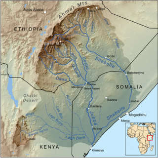
The Jubba River or Juba River is a river in southern Somalia which flows through the region of Jubaland. It begins at the border with Ethiopia, where the Dawa and Ganale Dorya rivers meet, and flows directly south to the Somali Sea, where it empties at the Goobweyn juncture. The Jubba basin covers an area of 749,000 km2 (289,000 sq mi). The Somali regional state of Jubaland, formerly called Trans-Juba, is named after the river.
Kismayo is a port city in the southern Lower Juba province of Somalia. It is the commercial capital of the autonomous Jubaland region.
The Bajuni Islands are an archipelago in southern Somalia. They are situated in the Somali sea off the southern coast of Jubaland, from Kismayo to Ras Kiyamboni.
The Marehan is a Somali clan, which is part of one of the largest Somali clan families, the Darod.

Garissa is the capital of Garissa County, Kenya. It is situated in the former North Eastern Province.
The fall of Kismayo occurred on January 1, 2007, when the troops of Somalia's Transitional Federal Government (TFG) and Ethiopian forces entered the Somali city of Kismayo unopposed. It came after the Islamic Courts Union's forces faltered and fled in the Battle of Jilib, abandoning their final stronghold.

Mai-Mai, commonly spelled Maay Maay, is one of the Somali languages. It is mainly spoken in Somalia and adjacent parts of Ethiopia and Kenya. In Somalia, it is spoken in South West state, Jubaland state, and Banadir.
Ceel Buur is a town located in the region of Galguduud in central Somalia.

Oltre Giuba or Trans-Juba was an Italian colony in the territory of Jubaland in present-day southern Somalia. It lasted from 1924 until 1926, when it was absorbed into Italian Somaliland. Transjuba is the former name of Jubaland, a federal member state of Somalia.

The Somali Civil War (2009–present) is the ongoing phase of the Somali Civil War which is concentrated in southern and central Somalia. It began in late January 2009 with the present conflict mainly between the forces of the Federal Government of Somalia assisted by African Union peacekeeping troops and al-Shabaab militants who pledged allegiance to al-Qaeda during 2012.
Paul Reichard was a German explorer who traveled extensively in the African continent. His discoveries led to the establishment of the German East Africa Protectorate.

This is a 2012 timeline of events in the Somali Civil War (2009–present).
The Battle of Kismayo was an offensive led by the Kenya Defence Forces, under the codename Operation Sledge Hammer, to seize the port city of Kismayo, Somalia, from Al-Shabaab from 28 September 2012. Members of the Raskamboni movement militia were part of the amphibious force.
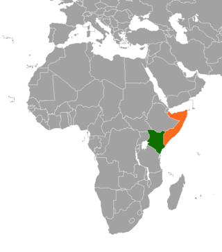
Kenya–Somalia relations are bilateral relations between Kenya and Somalia. Both countries are members of the African Union and Non-Aligned Movement.

Jubaland, or the Juba Valley, is a Federal Member State in southern Somalia. Jubba River, stretching from Dolow to the Indian Ocean, while its western side flanks the North Eastern Province in Kenya, which was carved out of Jubaland during the colonial period.
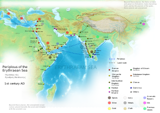
Nikon was a proto-Somali ancient coastal emporium in the Horn of Africa. It was described in the 1st century CE Greco-Roman travelogue the Periplus of the Erythraean Sea as being situated in the vicinity of Port Dunford in the southern Jubaland region of present-day Somalia.

Karl Ludwig Jühlke was a German explorer. He was a leading member of the team which in 1885 set the groundwork for creating the colony of German East Africa. His killing in Kismayo at the end of 1886 by a Somali, who remains unnamed in sources, provoked strong government anger in Berlin where it was reported as a murder undertaken on instructions which came, it was not unreasonable to conclude, from the Sultan of Zanzibar.
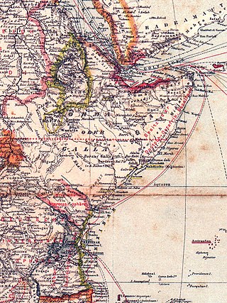
German colonial efforts on the Somali coast were pursued from 1885 to 1890. Representatives of the German East Africa Company signed friendship and protection treaties with local rulers in the coastal cities of Somalia in 1885 and 1886 with the aim of acquiring areas north of Wituland. In 1888 and 1890, respectively, the project, which overlapped with British and Italian claims, was abandoned.

When the central government of Somalia collapsed in 1991, the once firmly regulated Somali charcoal trade reopened. In the 1990s, the Somali Civil War, destructive El Niño floods, and reduced access to the European market caused the former prosperous banana industry to collapse, leading to an increase in reliance on the charcoal trade.
