
The Swan River is a major river in the southwest of Western Australia. The river runs through the metropolitan area of Perth, Western Australia's capital and largest city.

Bassendean is a north-eastern suburb of Perth, Western Australia. Its local government area is the Town of Bassendean.

Great Eastern Highway is a 590-kilometre-long (370 mi) road that links the Western Australian capital of Perth with the city of Kalgoorlie. A key route for road vehicles accessing the eastern Wheatbelt and the Goldfields, it is the western portion of the main road link between Perth and the eastern states of Australia. The highway forms the majority of National Highway 94, although the alignment through the Perth suburbs of Guildford and Midland, and the eastern section between Coolgardie and Kalgoorlie are not included. Various segments form parts of other road routes, including National Route 1, Alternative National Route 94, and State Route 51.

Crown Perth is a resort and casino located in Burswood, Western Australia, near the Swan River. The resort consists of a casino, a convention centre with meeting rooms, theatre and two ballrooms along with 32 restaurants and bars, a nightclub and recreational facilities. It also features three hotels: the 405-room Crown Metropol Perth, the 291-room Crown Promenade Perth and the 500-room luxury hotel Crown Towers Perth, which was opened in December 2016. The Crown Perth is one of several Crown Resorts located in capital cities across the country.
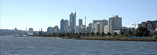
Perth Water is a section of the Swan River on the southern edge of the central business district of Perth, Western Australia. It is between the Causeway to the east, and Narrows Bridge to the west – a large wide but shallow section of river, and the northern edge of the suburb South Perth. It is considered a landmark of the City of Perth.

Burswood is an inner southeastern suburb of Perth, Western Australia, located immediately across the Swan River from Perth's central business district (CBD). Its local government area is the Town of Victoria Park. Burswood is the location of the State Tennis Centre, Perth Stadium, Belmont Park Racecourse, and the Crown Perth casino and hotel complex.

The Causeway is an arterial traffic crossing in Perth, Western Australia, linking the inner-city suburbs of East Perth and Victoria Park. It is carried over the Swan River at the eastern end of Perth Water by two bridges on either side of Heirisson Island. The current Causeway is the third structure to have been built across the river at this point.

Guildford is a suburb of Perth, Western Australia, 12 km northeast of the city centre within the City of Swan. Guildford was founded in 1829 as one of the earliest settlements of the Swan River Colony. It is one of only three towns in the metropolitan area listed on the Register of the National Trust.
Perth is the capital city of Western Australia. It was established by Britain as the Swan River Colony in 1829. The area had been explored by Europeans as early as 1697, and occupied by the Indigenous Whadjuk Noongar people for millennia.

Bayswater is a suburb 6 kilometres (4 mi) north-east of the central business district (CBD) of Perth, the capital of Western Australia. It is just north of the Swan River, within the City of Bayswater local government area. It is predominantly a low-density residential suburb consisting of single-family detached homes. However, there are several clusters of commercial buildings, most notably in the suburb's town centre, around the intersection of Whatley Crescent and King William Street and a light industrial area in the suburb's east.

Perth Stadium, currently known as Optus Stadium for sponsorship reasons, is a multi-purpose stadium in Perth, Western Australia, located in the suburb of Burswood. It was completed in late 2017 and officially opened on 21 January 2018. The stadium's total capacity is 61,266, including standing room, making it the third-largest stadium in Australia. The stadium can be extended up to 65,000 seats for rectangular sports.

Claise Brook is a stream which empties into Claisebrook Cove before running into the Swan River in Perth, Western Australia. The area surrounding the stream is on the outskirts of the Perth CBD and is part of the suburb of East Perth. Claise Brook was once an important water course from which the numerous interconnected fresh water lakes north of Perth emptied into during the wet season before entering the Swan River.

Bunbury Bridge was a single-track, timber railway bridge in East Perth in Western Australia. The bridge crossed the Swan River near Claise Brook and was built for passenger and freight traffic to Bunbury on the South Western Railway.
Dallas Reginald Dempster was an Australian businessman notable for the original development of Perth's Burswood Resort and Casino and the proposed Kwinana Petrochemical Plant, both of which were among the Western Australian government transactions examined by the 1990–92 WA Inc Royal Commission. In November 2013 The West Australian newspaper named Dempster as one of Western Australia's 100 most influential business leaders (1829–2013).
There are few canals in Australia. Of the canals constructed, only a small number are navigable waterways. The following list provides a summary of known navigable waterways and other types of constructed or artificial waterways in Australia.
The Castlemaine Brewery was opened in 1896 by Howard Norman Sleigh at Riverside Road in East Fremantle, Western Australia and boasted a successful trading history until 1927 when the company was taken over by the Swan Brewery.
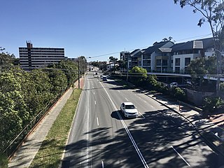
Guildford Road is a major road in Perth, Western Australia, linking the inner-city suburb of Mount Lawley with Guildford in the north-east. The ten-kilometre-long (6.2 mi) road runs mostly parallel to the Swan River, on its northern side, and is part of State Route 51, which runs between Perth's CBD and Midvale. Guildford Road is maintained and controlled by Main Roads Western Australia, which uses the internal designation "H026 Guildford Road" for Guildford Road, as well as Bridge Street and James Street in Guildford. In the 1930s, the name Great Eastern Highway was coined to describe the road, but was actually used for the road on the other side of the Swan River.

Garratt Road Bridge consists of two adjacent bridges over the Swan River, linking the suburbs of Bayswater and Ascot in Perth, Western Australia. The upstream bridge was built in 1935, while the matching downstream bridge was built in 1972. The site was significant prior to the construction of Garratt Road Bridge – it featured in Aboriginal mythology, and was in the near vicinity of 1880s bridges for pedestrians and trains. From that time there were various proposal to provide a vehicular crossing between Bayswater and Bassendean. Interest peaked in 1928, but plans were delayed due to the Great Depression. The first bridge, designed by Main Roads Chief Engineer Ernest Godfrey, was constructed in 1934–35. It allowed two lanes of traffic to cross the Swan River, alongside pedestrians on an adjacent footbridge.

The Belmont Railway Line was a branch railway in Western Australia that extended from the Eastern Railway at Bayswater to Belmont near the Ascot Racecourse. The line closed in 1956.
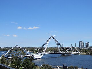
Matagarup Bridge is a suspension pedestrian bridge crossing over the Swan River in Perth, Western Australia. Situated approximately half-way between Heirisson Island and the Goongoongup Bridge, it provides pedestrian access between Burswood and East Perth. The bridge connects visitors to the Burswood Peninsula, including the Perth Stadium, with public transport and car parks in East Perth and the Perth central business district.

