
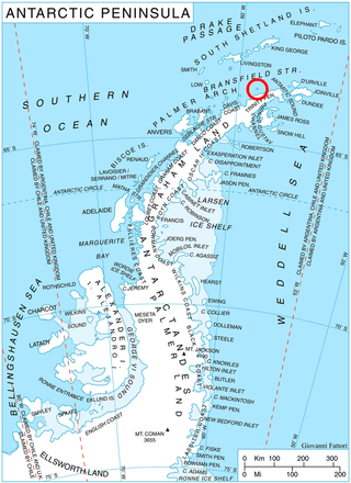
James Ross Island is a large island off the southeast side and near the northeastern extremity of the Antarctic Peninsula, from which it is separated by Prince Gustav Channel. Rising to 1,630 metres (5,350 ft), it is irregularly shaped and extends 64 km in a north–south direction. It was charted in October 1903 by the Swedish Antarctic Expedition under Otto Nordenskiöld, who named it for Sir James Clark Ross, the leader of a British expedition to this area in 1842 that discovered and roughly charted a number of points along the eastern side of the island. The style, "James" Ross Island is used to avoid confusion with the more widely known Ross Island in McMurdo Sound.
Astrolabe Island, located at 63°17′S58°40′W, is an island 5 km (3 mi) long, lying in the Bransfield Strait 23 km (14 mi) northwest of Cape Ducorps, Trinity Peninsula in Antarctica. It was discovered by the French expedition, 1837–40, under Captain Jules Dumont d'Urville, and named by him for his chief expedition ship, the Astrolabe. The island was photographed from the air and triangulated by FIDASE, 1956–57.
Abel Nunatak is the easternmost of two isolated nunataks on the south side of Broad Valley, Trinity Peninsula. It is a volcanic feature and an inferred vent of the James Ross Island Volcanic Group.

Aitkenhead Glacier is a 10-mile (16 km) long glacier flowing east-southeast from the Detroit Plateau, Graham Land, into Prince Gustav Channel. It was mapped from surveys by the Falkland Islands Dependencies Survey (FIDS) (1960–61), and named by the United Kingdom Antarctic Place-Names Committee for Neil Aitkenhead, a FIDS geologist at Hope Bay (1959–60).
Kanitz Nunatak is the rocky peak rising to 659 m in the southern foothills of Laclavère Plateau on Trinity Peninsula, Antarctic Peninsula. Situated 8.43 km south of Ami Boué Bluff, 9.81 km east-southeast of Dabnik Peak, 6.15 km north of Cain Nunatak and 9.84 km west by south of Theodolite Hill. Overlooking Broad Valley to the south.
Buttress Hill is a flat-topped hill, 690 metres (2,260 ft) high, with steep rock cliffs on the west side, standing 2 nautical miles (4 km) east of the most northern of the Seven Buttresses on Tabarin Peninsula in the northeastern extremity of the Antarctic Peninsula. It is an inferred volcanic vent of the James Ross Island Volcanic Group and was charted in 1946 by the Falkland Islands Dependencies Survey, so named because of its proximity to the Seven Buttresses.
The Camel Nunataks are two similar rock nunataks rising to 450 metres (1,480 ft), 1 nautical mile (2 km) apart, and 8 nautical miles (15 km) north of View Point and 8.68 km northwest of Garvan Point, Trinity Peninsula. The name is descriptive and has been in use amongst Falkland Islands Dependencies Survey personnel at Hope Bay since about 1959.
Cone Nunatak is a nunatak, 350 metres (1,150 ft) high, which appears conical on its north side but has brown rock cliffs on its south face, lying 3 nautical miles (6 km) south-southeast of Buttress Hill on the Tabarin Peninsula, at the northeast extremity of the Antarctic Peninsula. It represents a volcanic vent of the James Ross Island Volcanic Group.
Vortex Island is an island 0.5 nautical miles (0.9 km) long and 245 m high, lying in the northeast part of Prince Gustav Channel about 2 nautical miles (3.7 km) west-southwest of Corry Island, close south of Trinity Peninsula. Islands in this area were first seen by a party under J. Gunnar Andersson of the Swedish Antarctic Expedition, 1901–04. Vortex Island was first charted by the Falkland Islands Dependencies Survey (FIDS) in August 1945. The FIDS survey party was forced to lie idle there by a whirlwind snowstorm, thus suggesting the name.
Tufft Nunatak is a small nunatak 3 nautical miles (6 km) southwest of Mount Bradley and 4.6 km south of Senokos Nunatak, Trinity Peninsula in Graham Land, Antarctica. Named by United Kingdom Antarctic Place-Names Committee (UK-APC) for Roger Tufft of the Falkland Islands Dependencies Survey (FIDS), a member of the reconnaissance party for the Detroit Plateau journey in February 1957.
Panhard Nunatak is the nearest nunatak to the coast on the north side of Russell East Glacier, surmounting Smokinya Cove in Trinity Peninsula, Antarctica. Named by United Kingdom Antarctic Place-Names Committee (UK-APC) for René Panhard (1841–1908), French engineer who in 1891 was jointly responsible with E. Levassor for a motor car design which originated the principles on which most subsequent developments were based.
Gamma Hill is a distinctive ice-covered hill on Tabarin Peninsula, Antarctica, rising more than 300 metres (980 ft) on the shore of Fridtjof Sound. It is an inferred volcanic vent of the James Ross Island Volcanic Group.
Misty Pass is a pass, 700 metres (2,300 ft) high, between the head of Broad Valley and Ogoya Glacier descending north to Bransfield Strait, situated 8 nautical miles (15 km) southeast of Cape Ducorps on Trinity Peninsula, Antarctica. It was mapped by the Falkland Islands Dependencies Survey in 1946, and so named because clouds pouring east through the pass had been noted by the survey party to herald bad weather.
The Tongue Rocks are a small set of ice-free volcanic rocks lying between Eagle Island and Beak Island, off Trinity Peninsula, Antarctica. They are part of the James Ross Island Volcanic Group and were named by United Kingdom Antarctic Place-Names Committee (UK-APC) in association with Eagle and Beak Islands.
Rosamel Island is a circular island 1.9 km (1.2 mi) in diameter with precipitous cliffs of volcanic rock rising to a snow-covered peak 435 m (1,427 ft) high, lying west of Dundee Island in the south entrance to Antarctic Sound. It is part of the James Ross Island Volcanic Group.
Levassor Nunatak is a conspicuous horseshoe-shaped nunatak 1 nautical mile (2 km) inland in the middle of Cugnot Ice Piedmont, Trinity Peninsula, Antarctica. It was mapped from surveys by the Falkland Islands Dependencies Survey (1960–61), and was named by the UK Antarctic Place-Names Committee for French engineer Émile Levassor, who in 1891 was jointly responsible with René Panhard for a motor car design which originated the principles on which most subsequent developments were based.
Skomlya Hill is a rocky hill rising to 353 m at the base of a promontory that projects from Trinity Peninsula in Graham Land, Antarctica, 5.5 km eastwards into Prince Gustav Channel and ending in View Point. Surmounting Duse Bay to the northeast and Eyrie Bay to the southwest.
Kumata Hill is the partly ice-free hill rising to 552 m on the east side of Stepup Col on Trinity Peninsula in Graham Land, Antarctica. It is surmounting Broad Valley to the north and Cugnot Ice Piedmont to the south.
Hitar Petar Nunatak is the rocky hill rising to 434 m on the coast of Prince Gustav Channel, facing Alectoria Island and next south of the terminus of Aitkenhead Glacier on Trinity Peninsula in Graham Land, Antarctica.
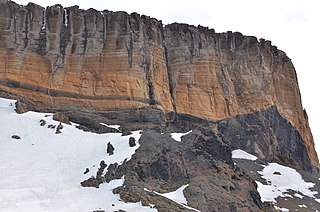
The James Ross Island Volcanic Group is a stratigraphic unit of Cenozoic age distributed on James Ross Island and Vega Island of the James Ross Island group, the Tabarin and Trinity peninsulas of Graham Land and surrounding islands in the Prince Gustav and Antarctic sounds.
