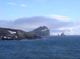
Deception Island is an island in the South Shetland Islands close to the Antarctic Peninsula with a large and safe natural harbor. This island is the caldera of an active volcano, which seriously damaged local scientific stations in 1967 and 1969. The island previously held a whaling station; it is now the most popular tourist destination with over 15,000 visitors per year. Two research stations are operated by Argentina and Spain during the summer season. While various countries have asserted sovereignty, it is still administered under the Antarctic Treaty System.
The Advisory Committee on Antarctic Names is an advisory committee of the United States Board on Geographic Names responsible for recommending commemorative names for features in Antarctica.

The Shackleton Range is a mountain range in Antarctica. Rising at Holmes Summit to 1,875 metres (6,152 ft), it extends in an east–west direction for about 160 kilometres (99 mi) between the Slessor and Recovery glaciers.

The Pensacola Mountains are a large group of mountain ranges of the Transantarctic Mountains System, located in the Queen Elizabeth Land region of Antarctica.
The Queen Maud Mountains are a major group of mountains, ranges and subordinate features of the Transantarctic Mountains, lying between the Beardmore and Reedy Glaciers and including the area from the head of the Ross Ice Shelf to the Antarctic Plateau in Antarctica. Captain Roald Amundsen and his South Pole party ascended Axel Heiberg Glacier near the central part of this group in November 1911, naming these mountains for the Norwegian queen Maud of Wales. Despite the name, they are not located within Queen Maud Land.
The Britannia Range is an Antarctic mountain range bounded by the Hatherton and Darwin glaciers on the north and the Byrd Glacier on the south, westward of the Ross Ice Shelf. Discovered by the British National Antarctic Expedition (1901–04) under Scott.

James Ross Island is a large island off the southeast side and near the northeastern extremity of the Antarctic Peninsula, from which it is separated by Prince Gustav Channel. Rising to 1,630 metres (5,350 ft), it is irregularly shaped and extends 64 km in a north–south direction. It was charted in October 1903 by the Swedish Antarctic Expedition under Otto Nordenskiöld, who named it for Sir James Clark Ross, the leader of a British expedition to this area in 1842 that discovered and roughly charted a number of points along the eastern side of the island. The style, "James" Ross Island is used to avoid confusion with the more widely known Ross Island in McMurdo Sound.
The UK Antarctic Place-Names Committee is a United Kingdom government committee, part of the Foreign and Commonwealth Office, responsible for recommending names of geographical locations within the British Antarctic Territory (BAT) and the South Georgia and the South Sandwich Islands (SGSSI). Such names are formally approved by the Commissioners of the BAT and SGSSI respectively, and published in the BAT Gazetteer and the SGSSI Gazetteer maintained by the Committee. The BAT names are also published in the international Composite Gazetteer of Antarctica maintained by SCAR.

Adelaide Island is a large, mainly ice-covered island, 139 kilometres (75 nmi) long and 37 kilometres (20 nmi) wide, lying at the north side of Marguerite Bay off the west coast of the Antarctic Peninsula. The Ginger Islands lie off the southern end. Mount Bodys is the easternmost mountain on Adelaide Island, rising to over 1,220 m. The island lies within the Argentine, British and Chilean Antarctic claims.

Snow Hill Island is an almost completely snowcapped island, 33 km (21 mi) long and 12 km (7.5 mi) wide, lying off the east coast of the Antarctic Peninsula. It is separated from James Ross Island to the north-east by Admiralty Sound and from Seymour Island to the north by Picnic Passage. It is one of several islands around the peninsula known as Graham Land, which is closer to Argentina and South America than any other part of the Antarctic continent.
The Seal Nunataks are a group of 16 islands called nunataks emerging from the Larsen Ice Shelf east of Graham Land, Antarctic Peninsula. The Seal Nunataks have been described as separate volcanic vents of ages ranging from Miocene to Pleistocene. There are unconfirmed reports of Holocene volcanic activity.

Black Island, in the Ross Archipelago, is immediately west of White Island. It was first named by the Discovery Expedition (1901–04) because of its lack of snow. The island's northernmost point is named Cape Hodgson, commemorating Thomas Vere Hodgson, one of the oldest members of the Discovery Expedition.
The Mühlig-Hofmann Mountains is a major group of associated mountain features extending east to west for 100 km (62 mi) between the Gjelsvik Mountains and the Orvin Mountains in Queen Maud Land, East Antarctica. With its summit at 3,148 metres (10,328 ft), the massive Jøkulkyrkja Mountain forms the highest point in the Mühlig-Hofmann Mountains.
Cone Nunatak is a nunatak, 350 metres (1,150 ft) high, which appears conical on its north side but has brown rock cliffs on its south face, lying 3 nautical miles (6 km) south-southeast of Buttress Hill on the Tabarin Peninsula, at the northeast extremity of the Antarctic Peninsula. It represents a volcanic vent of the James Ross Island Volcanic Group.
Cape Purvis is a cape forming the south extremity of Dundee Island, off the north tip of Antarctic Peninsula. Its topography is that of a promontory which forms a mesa. The rest of the island is smooth.
San Jose Pass is a pass trending NW-SE and rising to about 200 m between Lachman Crags and Stickle Ridge on James Ross Island. On either side of this pass there are exposures of fossiliferous Cretaceous rocks. Following work in the area, named "Paso San Jose" after Saint Joseph by an Argentine Antarctic Expedition.
Argo Point is a scoria cone in Jason Peninsula, Antarctica, at a height of 360 metres (1,180 ft) above sea level. Associated with the Seal Nunataks, the cone has a diameter of 300 metres (980 ft) and its snow-filled crater has a gap on its northern side. The cone is constructed on a formation of lava and scoria over 175 metres (574 ft) thick, which may lie on Jurassic rocks.
The McMurdo Volcanic Group is a large group of Cenozoic volcanic rocks in the western Ross Sea and central Transantarctic Mountains areas of Antarctica. It is one of the largest provinces of alkaline volcanism in the world, having formed as a result of continental rifting along the West Antarctic Rift System.
Berry Hill is a hill rising to 370 m between Lachman Crags and Cape Lachman on James Ross Island. The hill is notable for an exposure of volcanic rocks and probable glacial beds of Pliocene age. Named by the United Kingdom Antarctic Place-Names Committee (UK-APC), 1987, after Alfred Thomas Berry, Chief Steward in Discovery II, 1929–39; in charge of stores on Operation Tabarin at Port Lockroy, 1943–44, and Hope Bay, 1944–45.
