
Mount Terror is a large shield volcano that forms the eastern part of Ross Island, Antarctica. It has numerous cinder cones and domes on the flanks of the shield and is mostly under snow and ice. It is the second largest of the four volcanoes which make up Ross Island and is somewhat overshadowed by its neighbour, Mount Erebus, 30 km (19 mi) to the west. Mount Terror was named in 1841 by Sir James Clark Ross for his second ship, HMS Terror. The captain of Terror was Francis Crozier, a close friend of Ross for whom the nearby Cape Crozier is named.

James Ross Island is a large island off the southeast side and near the northeastern extremity of the Antarctic Peninsula, from which it is separated by Prince Gustav Channel. Rising to 1,630 metres (5,350 ft), it is irregularly shaped and extends 64 km in a north–south direction. It was charted in October 1903 by the Swedish Antarctic Expedition under Otto Nordenskiöld, who named it for Sir James Clark Ross, the leader of a British expedition to this area in 1842 that discovered and roughly charted a number of points along the eastern side of the island. The style, "James" Ross Island is used to avoid confusion with the more widely known Ross Island in McMurdo Sound.

Snow Hill Island is an almost completely snowcapped island, 33 km (21 mi) long and 12 km (7.5 mi) wide, lying off the east coast of the Antarctic Peninsula. It is separated from James Ross Island to the north-east by Admiralty Sound and from Seymour Island to the north by Picnic Passage. It is one of several islands around the peninsula known as Graham Land, which is closer to Argentina and South America than any other part of the Antarctic continent.

The Seal Nunataks are a group of 16 islands called nunataks emerging from the Larsen Ice Shelf east of Graham Land, Antarctic Peninsula. The Seal Nunataks have been described as separate volcanic vents of ages ranging from Miocene to Pleistocene. There are unconfirmed reports of Holocene volcanic activity.

Cain Nunatak is the westernmost of two isolated nunataks on the south side of Broad Valley, situated 3.37 km east-northeast of Kumata Hill on Trinity Peninsula, Antarctica. It is a volcanic feature and an inferred vent of the James Ross Island Volcanic Group.
Kienle Nunataks are three aligned nunataks to the north of Mount Terror in northeastern Ross Island, Antarctica. The nunataks trend east–west for 1 nautical mile (2 km) and rise to about 1,700 metres (5,600 ft). The central nunatak is 2.5 nautical miles (5 km) north-northeast of the Mount Terror summit. At the suggestion of P.R. Kyle, they were named by the Advisory Committee on Antarctic Names after Juergen Kienle of the Geophysical Institute, University of Alaska Fairbanks, a United States Antarctic Program team leader for the investigation of volcanic activity and seismicity on Mount Erebus in six field seasons, 1980–81 through 1985–86.
The New Zealand Geological Survey Antarctic Expedition (NZGSAE) describes a series of scientific explorations of the continent Antarctica. The expeditions were notably active throughout the 1950s and 1960s.
Centipede Nunatak is a narrow nunatak that is 0.3 nautical miles (0.6 km) long, located 0.8 nautical miles (1.5 km) north-northwest of Ford Rock in central Hut Point Peninsula, Ross Island. The name is allusive; snow that cuts across parts of the nunatak gives it a segmented appearance resembling that of a centipede. It was named by the Advisory Committee on Antarctic Names in 2000.
Cone Nunatak is a nunatak, 350 metres (1,150 ft) high, which appears conical on its north side but has brown rock cliffs on its south face, lying 3 nautical miles (6 km) south-southeast of Buttress Hill on the Tabarin Peninsula, at the northeast extremity of the Antarctic Peninsula. It represents a volcanic vent of the James Ross Island Volcanic Group.
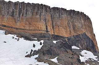
Organpipe Nunatak is a nunatak rising to 150 m in the glacier flowing west into Holluschickie Bay, in northwest James Ross Island. Named descriptively following British Antarctic Survey (BAS) geological work on the island, 1985–86, from the excellent columnar jointing exhibited on the feature.
Stuckless Glacier is a broad glacier in the southwest part of Black Island, Ross Archipelago. If flows southwest between Rowe Nunataks and Cape Beck to Moraine Strait, McMurdo Ice Shelf. Named by Advisory Committee on Antarctic Names (US-ACAN) (1999) after John S. Stuckless, Department of Geology, Northern Illinois University, DeKalb, who, in several seasons from 1972–73, investigated the geochemistry of McMurdo volcanic rocks, correlating samples from several Ross Island sites with DVDP core samples obtained in McMurdo Dry Valleys.
Palisade Nunatak is a substantial rock nunatak just north of Rohss Bay and 2 nautical miles (3.7 km) southeast of Hidden Lake on James Ross Island. Mapped from surveys by Falkland Islands Dependencies Survey (FIDS) (1960–61). This distinctive ridge-backed nunatak with vertical columnar structure is the largest outcrop of hard intrusive rock on James Ross Island. Named by United Kingdom Antarctic Place-Names Committee (UK-APC) for its resemblance to a palisade.
Sentinel Buttress is a prominent crag containing a volcanic breccia sequence, rising to 535 m east of Palisade Nunatak at the head of Rohss Bay, James Ross Island. So named by the United Kingdom Antarctic Place-Names Committee (UK-APC) in 1987 from its commanding position in the area.
The Kea Nunataks are a line of several nunataks 1.2 nautical miles (2.2 km) southeast of the summit of Mount Bird, Ross Island, Antarctica. The feature trends northwest–southeast and is 1.5 nautical miles (3 km) long. This is one of several features near Mount Bird assigned the native name of a New Zealand mountain bird, in this case a kea. It was named by the New Zealand Geographic Board in 2000.
Rowe Nunataks is a cluster of nunataks 3 nautical miles (6 km) northwest of Cape Beck in the southwest part of Black Island, Ross Archipelago. Named by Advisory Committee on Antarctic Names (US-ACAN) (1999) after C.A. Rowe, Geophysical Institute, University of Alaska, Fairbanks, who investigated volcanic activity and seismicity at nearby Mount Erebus, 1984–85 and 1985–86.
Argo Point is a scoria cone in Jason Peninsula, Antarctica, at a height of 360 metres (1,180 ft) above sea level. Associated with the Seal Nunataks, the cone has a diameter of 300 metres (980 ft) and its snow-filled crater has a gap on its northern side. The cone is constructed on a formation of lava and scoria over 175 metres (574 ft) thick, which may lie on Jurassic rocks.

The geology of the Isle of Mull in Scotland is dominated by the development during the early Palaeogene period of a ‘volcanic central complex’ associated with the opening of the Atlantic Ocean. The bedrock of the larger part of the island is formed by basalt lava flows ascribed to the Mull Lava Group erupted onto a succession of Mesozoic sedimentary rocks during the Palaeocene epoch. Precambrian and Palaeozoic rocks occur at the island's margins. A number of distinct deposits and features such as raised beaches were formed during the Quaternary period.
The James Ross Island Volcanic Group is a stratigraphic unit of Cenozoic age distributed on James Ross Island and Vega Island of the James Ross Island group, the Tabarin and Trinity peninsulas of Graham Land and surrounding islands in the Prince Gustav and Antarctic sounds.
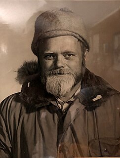
Lieutenant Commander James Florian Brandau, US Navy, retired, served multiple tours in Antarctica as a helicopter pilot as part of the U.S. Navy squadron VX-6. Several geological features in Antarctica are named in his honor, and he is featured in the literature and lore from there.