The Pas-de-Calais is a department in northern France named after the French designation of the Strait of Dover, which it borders. It has the most communes of all the departments of France, 890, and is the 8th most populous. It had a population of 1,465,278 in 2019. The Calais Passage connects to the Port of Calais on the English Channel. The Pas-de-Calais borders the departments of Nord and Somme and is connected to the English county of Kent via the Channel Tunnel.
Nord-Pas-de-Calais ; Picard: Nord-Pas-Calés); is a former administrative region of France. Since 1 January 2016, it has been part of the new region Hauts-de-France. It consisted of the departments of Nord and Pas-de-Calais. Nord-Pas-de-Calais borders the English Channel (west), the North Sea (northwest), Belgium and Picardy (south). The majority of the region was once part of the historical Southern Netherlands, but gradually became part of France between 1477 and 1678, particularly during the reign of king Louis XIV. The historical French provinces that preceded Nord-Pas-de-Calais are Artois, French Flanders, French Hainaut and (partially) Picardy. These provincial designations are still frequently used by the inhabitants.

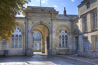
Calais is a port city in the Pas-de-Calais department, of which it is a subprefecture. Although Calais is by far the largest city in Pas-de-Calais, the department's prefecture is its third-largest city of Arras. The population of the city proper is 67,544; that of the urban area is 144,625 (2020). Calais overlooks the Strait of Dover, the narrowest point in the English Channel, which is only 34 km (21 mi) wide here, and is the closest French town to England. The White Cliffs of Dover can easily be seen on a clear day from Calais. Calais is a major port for ferries between France and England, and since 1994, the Channel Tunnel has linked nearby Coquelles to Folkestone by rail.

Calais is a city in Washington County, Maine, United States. As of the 2020 census, it had a population of 3,079, making Calais the third least-populous city in Maine. The city has three Canada–US border crossings over the St. Croix River connecting to St. Stephen, New Brunswick, Canada.

William de St-Calais was a medieval Norman monk, abbot of the abbey of Saint-Vincent in Le Mans in Maine, who was nominated by King William I of England as Bishop of Durham in 1080. During his term as bishop, St-Calais replaced the canons of his cathedral chapter with monks, and began the construction of Durham Cathedral. In addition to his ecclesiastical duties, he served as a commissioner for the Domesday Book of 1086. He was also a councillor and advisor to both King William I and his son, King William II, known as William Rufus. Following William Rufus' accession to the throne in 1087, St-Calais is considered by scholars to have been the new king's chief advisor.

Boursin is a commune in the Pas-de-Calais department in the Hauts-de-France region in northern France.

The Burghers of Calais is a sculpture by Auguste Rodin in twelve original castings and numerous copies. It commemorates an event during the Hundred Years' War, when Calais, a French port on the English Channel, surrendered to the English after an eleven-month siege. The city commissioned Rodin to create the sculpture in 1884 and the work was completed in 1889.

Coquelles is a commune in the Pas-de-Calais department near Calais in northern France.

Bonningues-lès-Calais is a commune in the Pas-de-Calais department in the Hauts-de-France region in northern France.

Brévillers is a commune in the Pas-de-Calais department in the Hauts-de-France region in northern France.

Caffiers is a commune in the Pas-de-Calais department in the Hauts-de-France region of France.

Campagne-lès-Guines is a commune in the Pas-de-Calais department in the Nord-Pas de Calais region of France.

Fréthun is a commune in the Pas-de-Calais department in the Hauts-de-France region of France.

Nielles-lès-Calais is a commune in the Pas-de-Calais department in the Hauts-de-France region of France.

Thièvres is a commune in the Pas-de-Calais department in the Hauts-de-France region of France.

Andres is a commune in the Pas-de-Calais department in northern France.
The 13th constituency of the Pas-de-Calais was a former French legislative constituency which existed until 2012. It was one of 14 French legislative constituencies in the Pas-de-Calais department (62) located in the Nord-Pas-de-Calais region.

The 4th constituency of the Pas-de-Calais is a French legislative constituency in the Pas-de-Calais département.

The 7th constituency of the Pas-de-Calais is a French legislative constituency in the Pas-de-Calais département.

Hauts-de-France is the northernmost region of France, created by the territorial reform of French regions in 2014, from a merger of Nord-Pas-de-Calais and Picardy. Its prefecture is Lille. The new region came into existence on 1 January 2016, after regional elections in December 2015. The Conseil d'État approved Hauts-de-France as the name of the region on 28 September 2016, effective the following 30 September.


