Caleruega

Last updated
Caleruega
Municipality and town
Calleruega01.jpg
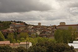
View of Caleruega, 2010
Bandera de Caleruega.svg
Caleruega Escudo.svg
Map-caleruega-spain.png
Location of Caleruega
Country Spain
Autonomous community Flag of Castile and Leon.svg Castile and León
Province Flag Burgos Province.svg Burgos
Comarca Ribera del Duero
Government
   Mayor José Ignacio Delgado (PRCAL)
Area
  Total47.63 km2 (18.39 sq mi)
Elevation
960 m (3,150 ft)
Population
 (2018) [1]
  Total433
  Density9.1/km2 (24/sq mi)
Time zone UTC+1 (CET)
  Summer (DST) UTC+2 (CEST)
Postal code
09451
Website http://www.caleruega.es/

Caleruega is a small town and municipality in the autonomous community of Castile-Leon, Spain. It is part of the Province of Burgos. The town is a few miles south of the Monastery of Santo Domingo de Silos.

Contents

People from Caleruega

Related Research Articles

<span class="mw-page-title-main">Liborina</span> Municipality and town in Antioquia Department, Colombia

Liborina is a town and municipality in the Colombian department of Antioquia. The population was 7,928 at the 2018 census.

<span class="mw-page-title-main">Villatuelda</span> Village and municipality

Villatuelda is a Spanish village and municipality in the province of Burgos, part of the autonomous community of Castile and León. It has a population of approximately 60 people and it is 30 km from Aranda de Duero.

<span class="mw-page-title-main">Alba de Cerrato</span> Municipality in Castile and León, Spain

Alba de Cerrato is a municipality located in the province of Palencia, Castile and León, Spain.

Baños de Valdearados is a municipality and town located in the province of Burgos, Castile and León, Spain. According to the 2004 census (INE), the municipality has a population of 424 inhabitants.

<span class="mw-page-title-main">Peñaranda de Duero</span> Municipality and town in Castile and León, Spain

Peñaranda de Duero is a village and municipio located in the province of Burgos, Castile and León, Spain. According to the 2004 census (INE), the municipality has a population of 583 inhabitants.

<span class="mw-page-title-main">La Sequera de Haza</span> Municipality in Castile and León, Spain

La Sequera de Haza is a municipality located in the province of Burgos, Castile and León, Spain. According to the 2004 census (INE), the municipality has a population of 53 inhabitants.

<span class="mw-page-title-main">Sotillo de la Ribera</span> Municipality and town in Castile and León, Spain

Sotillo de la Ribera is a municipality and town located in the province of Burgos, Castile and León, Spain. According to the 2004 census (INE), the municipality has a population of 603 inhabitants.

<span class="mw-page-title-main">Terradillos de Esgueva</span> Municipality and town in Castile and León, Spain

Terradillos de Esgueva is a municipality and town located in the province of Burgos, Castile and León, Spain. According to the 2022 census (INE), the municipality has a population of 69 inhabitants.

<span class="mw-page-title-main">Tórtoles de Esgueva</span> Municipality in Castile and León, Spain

Tórtoles de Esgueva is a municipality located in the province of Burgos, Castile and León, Spain. According to the 2004 census (INE), the municipality has a population of 529 inhabitants.

<span class="mw-page-title-main">Orcajo</span> Municipality in Aragon, Spain

Orcajo is a municipality located in the province of Zaragoza, Aragon, Spain. According to the 2004 census (INE), the municipality has a population of 39 inhabitants.

<span class="mw-page-title-main">Sestrica</span> Municipality in Aragon, Spain

Sestrica is a municipality located in the province of Zaragoza, Aragon, Spain. According to the 2004 census (INE), the municipality has a population of 460 inhabitants.

<span class="mw-page-title-main">Vera de Moncayo</span> Municipality in Aragon, Spain

Vera de Moncayo is a municipality located in the province of Zaragoza, Aragon, Spain. According to the 2004 census (INE), the municipality has a population of 432 inhabitants.

<span class="mw-page-title-main">Villanueva de Gállego</span> Place in Aragon, Spain

Villanueva de Gállego is a municipality located in the province of Zaragoza, Aragon, Spain. According to the 2004 census (INE), the municipality has a population of 3,662 inhabitants.

<span class="mw-page-title-main">Granja de Moreruela</span> Place in Castile and León, Spain

Granja de Moreruela is a municipality located in the province of Zamora, Castile and León, Spain. According to the 2004 census (INE), the municipality has a population of 337 inhabitants.

<span class="mw-page-title-main">San Martín de Valderaduey</span> Place in Castile and León, Spain

San Martín de Valderaduey is a municipality located in the Sanabria comarca, province of Zamora, Castile and León, Spain. According to the 2004 census (INE), the municipality has a population of 86 inhabitants. The town's main church is from the 10th century.

<span class="mw-page-title-main">Tábara</span> Place in Castile and León, Spain

Tábara is a municipality located in the province of Zamora, Castile and León, Spain. According to the 2004 census (INE), the municipality has a population of 950 inhabitants. Tábara is the capital of the Tierra de Tábara comarca.

<span class="mw-page-title-main">Torregamones</span> Place in Castile and León, Spain

Torregamones is a municipality located in the province of Zamora, Castile and León, Spain. According to the 2007 census (INE), the municipality has a population of 310 inhabitants. It plays a relative importance in the comarca of Sayago, as a link between Portugal and this zone of the province of Zamora. Apart from Portugal, Torregamones abuts with Villardiegua de la Ribera to the north, Moralina to the east and also Gamones to the south.

<span class="mw-page-title-main">Valtiendas</span> Municipality in Castile and León, Spain

Valtiendas is a municipality located in the province of Segovia, Castile and León, Spain. According to the 2004 census (INE), the municipality has a population of 161 inhabitants.

References

  1. Municipal Register of Spain 2018. National Statistics Institute.


41°49′N3°29′W / 41.817°N 3.483°W / 41.817; -3.483