This article needs additional citations for verification .(May 2024) |
Salas de los Infantes | |
|---|---|
Municipality and city | |
 Santa Cecilia church (15th century) | |
 Flag  Coat of arms | |
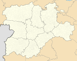 Salas de los Infantes Location  Salas de los Infantes Salas de los Infantes (Spain) | |
| Coordinates: 42°01′23″N3°16′53″W / 42.02306°N 3.28139°W | |
| Country | |
| Autonomous community | |
| Comarca | Sierra de la Demanda |
| Municipality | Salas de los Infantes |
| Government | |
| • Mayor | Marta Arroyo (PP) |
| Area | |
• Total | 31.319 km2 (12.092 sq mi) |
| • Land | 31 km2 (12 sq mi) |
| • Water | 0.00 km2 (0 sq mi) |
| Elevation | 964 m (3,163 ft) |
| Population (2025-01-01) [1] | |
• Total | 1,959 |
| Time zone | UTC+1 (CET) |
| • Summer (DST) | UTC+2 (CEST) |
| Postal code | 09600 |
| Website | http://www.salasdelosinfantes.net/ |
Salas de los Infantes is a municipality and city in Burgos province between La Rioja, Soria and Burgos city in Spain. It is hilly with many foothills and mountains. The mountain range Sierra de la Demanda with the black lagoon, La Laguna Negra, is nearby.