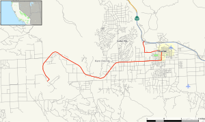
California State Route 202

Last updated

California 202.svg

State Route 202

California State Route 202 Map.svg

Map of Kern County in south central California with SR 202 highlighted in red
Route information
Defined by Streets and Highways Code § 502
Maintained by Caltrans
Length 10.53 mi [1] (16.95 km)
Major junctions
West end California Correctional Institution
East endCalifornia 58.svg SR 58 near Tehachapi
Location
Counties Kern
Highway system
California 201.svg SR 201 SR 203 California 203.svg

State Route 202 (SR 202) is a state highway in California, United States. It connects the California Correctional Institution to Route 58 in Tehachapi.

A state highway, state road, or state route is usually a road that is either numbered or maintained by a sub-national state or province. A road numbered by a state or province falls below numbered national highways in the hierarchy. Roads maintained by a state or province include both nationally numbered highways and un-numbered state highways. Depending on the state, "state highway" may be used for one meaning and "state road" or "state route" for the other.

California State of the United States of America

California is a state in the Pacific Region of the United States. With 39.6 million residents, California is the most populous U.S. state and the third-largest by area. The state capital is Sacramento. The Greater Los Angeles Area and the San Francisco Bay Area are the nation's second and fifth most populous urban regions, with 18.7 million and 8.8 million residents respectively. Los Angeles is California's most populous city, and the country's second most populous, after New York City. California also has the nation's most populous county, Los Angeles County, and its largest county by area, San Bernardino County. The City and County of San Francisco is both the country's second-most densely populated major city after New York City and the fifth-most densely populated county, behind only four of the five New York City boroughs.

California Correctional Institution

California Correctional Institution (CCI) is a supermax state prison located in Cummings Valley, west of the city of Tehachapi in southern California. CCI is sometimes referred to as "Tehachapi prison" or "Tehachapi". As stated by the California Department of Corrections and Rehabilitation, its overall mission is "to incarcerate and control felons, while providing the opportunity for meaningful work, training and other programs. The prison provides programs for those inmates who are willing to work and participate fully in available programs."

Contents

A portion of SR 202 is overlapped with SR 58 Business. That portion follows the alignment of decommissioned U.S. Route 466.

Route description

The road begins with its western terminus at the California Correctional Institution in Cummings Valley along West Valley Boulevard, its name for part of the route. SR 202 then heads eastward through a farmland area before entering a suburb area of Tehachapi. The road then abruptly turns north toward SR 58 Business where it is concurrent with the business route through town to its eastern end at State Route 58 with an interchange. [2]

Tehachapi, California City in California in US

Tehachapi is a city in Kern County, California, in the Tehachapi Mountains, at an elevation of 3,970 feet (1,210 m) between the San Joaquin Valley and the Mojave Desert.

California State Route 58 highway in California

State Route 58 is an east-west highway across the California Coast Ranges, the southern San Joaquin Valley, the Tehachapi Mountains, which border the southern Sierra Nevada, and the Mojave Desert. It runs between its western terminus near Santa Margarita and its eastern terminus in Barstow. It has junctions with Interstate 5 near Buttonwillow, State Route 99 in Bakersfield, State Route 202 in Tehachapi, State Route 14 in Mojave, and U.S. Route 395 at Kramer Junction. SR 58 gives good access to Edwards Air Force Base. At various points it is known as the Calf Canyon Highway, Carrisa Highway, Bakersfield-McKittrick Highway, Rosa Parks Highway, Rosedale Highway, Barstow-Bakersfield Highway, Kern County Korean War Veterans Memorial Highway, and Mojave-Barstow Highway.

SR 202 is part of the National Highway System, [3] a network of highways that are considered essential to the country's economy, defense, and mobility by the Federal Highway Administration. [4]

National Highway System (United States) highway system in the United States

The National Highway System (NHS) is a network of strategic highways within the United States, including the Interstate Highway System and other roads serving major airports, ports, rail or truck terminals, railway stations, pipeline terminals and other strategic transport facilities. Altogether, it constitutes the largest highway system in the world.

Federal Highway Administration government agency

The Federal Highway Administration (FHWA) is a division of the United States Department of Transportation that specializes in highway transportation. The agency's major activities are grouped into two programs, the Federal-aid Highway Program and the Federal Lands Highway Program. Its role had previously been performed by the Office of Road Inquiry, Office of Public Roads and the Bureau of Public Roads.

Major intersections

Except where prefixed with a letter, postmiles were measured on the road as it was in 1964, based on the alignment that existed at the time, and do not necessarily reflect current mileage. R reflects a realignment in the route since then, M indicates a second realignment, L refers an overlap due to a correction or change, and T indicates postmiles classified as temporary (for a full list of prefixes, see the list of postmile definitions). [5] Segments that remain unconstructed or have been relinquished to local control may be omitted. The entire route is in Kern County.

California postmile measurement

California uses a postmile highway location marker system on all of its state highways, including U.S. Routes and Interstate Highways. The postmile markers indicate the distance a route travels through individual counties, as opposed to milestones that indicate the distance traveled through a state. The postmile system is the only route reference system used by the California Department of Transportation (Caltrans).

In 1963 and 1964, the California Division of Highways implemented a major renumbering of its state highways. The majority of sign routes—those marked for the public—kept their numbers; the main changes were to the legislative routes, which had their numbers changed to match the sign routes. A large number of formerly unsigned routes received sign numbers corresponding to their new legislative numbers. A smaller change was the removal and truncating of many U.S. Routes in favor of the Interstate Highways, and the renumbering of State Routes that conflicted with Interstate numbers. Some U.S. Routes that were officially removed continued to be signed until the replacement Interstates were completed.

Kern County, California County in California, United States

Kern County is a county in the U.S. state of California. As of the 2010 census, the population was 839,631. Its county seat is Bakersfield.

LocationPostmile
[5] [1] [6]
DestinationsNotes
R1.48 California Correctional Institution West end of SR 202
Tehachapi R8.87Tucker Road, Valley Boulevard
11.43Business plate green.svg
California 58.svg SR 58 Bus. east (Tehachapi Boulevard) / Red Apple Avenue
West end of SR 58 Bus. overlap
12.01California 58.svg SR 58  Mojave, Bakersfield Interchange; east end of SR 58 Bus. overlap; east end of SR 202
1.000 mi = 1.609 km; 1.000 km = 0.621 mi

    See also

    Related Research Articles

    California State Route 45 highway in California

    State Route 45 is a state highway in the U.S. State of California that travels in a north–south direction from Route 113 in Knights Landing to Route 32 in Hamilton City.

    California State Route 129 highway in California

    State Route 129 is a state highway in the U.S. state of California in Santa Cruz County. The highway connects State Route 1 in Watsonville east to U.S. Route 101.

    California State Route 269 highway in California

    State Route 269 is a state highway in California, United States, which runs from Avenal to State Route 145.

    California State Route 229 highway in California

    State Route 229 is a short state highway in the U.S. state of California. The route runs from State Route 58 to State Route 41. It connects the small town of Creston with the rural state routes. Also, in conjunction with SR 58 and SR 41, it provides a slower, more scenic route between the Central Coast and the San Joaquin Valley.

    California State Route 151 highway in California

    State Route 151 is a state highway in the U.S. state of California. The route runs from Shasta Dam to Interstate 5 near Shasta Lake City, California. Its routing is in Shasta County, California.

    California State Route 217 highway in California

    State Route 217 is a short, two-and-a-half-mile-long, spur route in the U.S. state of California. The entire route is a freeway.

    California State Route 236 highway in California

    State Route 236 is a state highway in the U.S. state of California. It is a short 18-mile (29 km) "C" shaped highway that links to State Route 9 at both ends in the Santa Cruz Mountains. 236 links Route 9 with Governor's Camp in Big Basin State Park near the Waterman Gap.

    California State Route 167 highway in California

    State Route 167 is a state highway in the U.S. state of California in Mono County. From U.S. Route 395 it runs north of Mono Lake eastward to the Nevada state line where it meets State Route 359. At the west point of this highway, it runs almost directly east to west, and can be seen almost 15 miles (24 km) into the distance as a straight line.

    California State Route 284 highway in California

    State Route 284 is a short state highway in Plumas County, California. It is a spur route off from State Route 70 in Chilcoot connecting to Frenchman Lake.

    California State Route 169 highway in California

    State Route 169 is a state highway in northern California.

    California State Route 172 highway in California

    State Route 172 is a state highway in the U.S. state of California in Tehama County. It is a loop route off of State Route 36.

    California State Route 182 highway in California

    State Route 182 is a state highway in the U.S. state of California in Mono County. The route connects U.S. Route 395 in Bridgeport to State Route 338 at the Nevada state line via the East Walker River valley.

    California State Route 197 highway in California

    State Route 197 is a state highway in the U.S. state of California in Del Norte County near Crescent City. It is a bypass connecting U.S. Highways 199 and 101. It runs along the north bank of the Smith River.

    California State Route 200 highway in California

    State Route 200 is a state highway in the U.S. state of California near Arcata in Humboldt County. It is a cut-off connecting U.S. Route 101 and State Route 299. It runs along the north bank of the Mad River, to the north of the 101-299 junction.

    California State Route 201 highway in California

    State Route 201 is a state highway in the Central Valley of California, United States. It connects Route 99 in Kingsburg with Route 245. Route 63 bridges a discontinuity in the middle of the route.

    California State Route 223 highway in California

    State Route 223 is a state route in Kern County, California, and is locally known as Bear Mountain Boulevard. It is a truck route, connecting the agricultural land south of Bakersfield and east of SR 99/I-5, and the city of Arvin, to three major transportation corridors without having to drive through Bakersfield. It connects to I-5 for goods traveling north and east of Sacramento. It connects to SR 99 for goods traveling to major San Joaquin Valley communities. It also connects to SR 58, for goods traveling to all points southeast, except for Los Angeles. For goods traveling south, trucks use SR 99 while cars can use Wheeler Ridge Road, which is a north-south county road that connects to I-5 south of SR 99.

    California State Route 263 highway in California

    State Route 263 is a state highway in the U.S. state of California in Siskiyou County. It is also part of Business Loop 5 due to being a parallel route of Interstate 5 to the west. Route 263 connects Route 3 near the north city limits of Yreka to Route 96 eight miles north. It was once part of U.S. Route 99.

    California State Route 265 highway in California

    State Route 265, part of Weed Boulevard, is a state highway in the U.S. state of California in Siskiyou County.

    California State Route 273 highway in California

    State Route 273 is a state highway in Shasta County, California, United States. The route takes a more direct approach to the cities of Anderson and Redding, passing through their downtown districts. Interstate 5 is a bypass of this route, as it connects both ends. This route was part of former U.S. Route 99.

    References

    1. 1 2 California Department of Transportation (July 2007). "Log of Bridges on State Highways". Sacramento: California Department of Transportation.
    2. Microsoft; Nokia (2011-01-13). "California State Route 202" (Map). Bing Maps . Microsoft. Retrieved 2011-01-13.
    3. Federal Highway Administration (March 25, 2015). National Highway System: California (South) (PDF) (Map). Scale not given. Washington, DC: Federal Highway Administration. Retrieved September 15, 2017.
    4. Natzke, Stefan; Neathery, Mike & Adderly, Kevin (June 20, 2012). "What is the National Highway System?". National Highway System. Washington, DC: Federal Highway Administration. Retrieved July 1, 2012.
    5. 1 2 California Department of Transportation. "State Truck Route List". Sacramento: California Department of Transportation. Archived from the original (XLS file) on June 30, 2015. Retrieved June 30, 2015.
    6. California Department of Transportation, All Traffic Volumes on CSHS, 2007

    Route map: Google

    KML file (edithelp)
    KML is from Wikidata