
The ionosphere is the ionized part of the upper atmosphere of Earth, from about 48 km (30 mi) to 965 km (600 mi) above sea level, a region that includes the thermosphere and parts of the mesosphere and exosphere. The ionosphere is ionized by solar radiation. It plays an important role in atmospheric electricity and forms the inner edge of the magnetosphere. It has practical importance because, among other functions, it influences radio propagation to distant places on Earth. It also affects GPS signals that travel through this layer.

The magnetopause is the abrupt boundary between a magnetosphere and the surrounding plasma. For planetary science, the magnetopause is the boundary between the planet's magnetic field and the solar wind. The location of the magnetopause is determined by the balance between the pressure of the dynamic planetary magnetic field and the dynamic pressure of the solar wind. As the solar wind pressure increases and decreases, the magnetopause moves inward and outward in response. Waves along the magnetopause move in the direction of the solar wind flow in response to small-scale variations in the solar wind pressure and to Kelvin–Helmholtz instability.
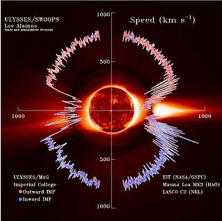
The solar wind is a stream of charged particles released from the Sun's outermost atmospheric layer, the corona. This plasma mostly consists of electrons, protons and alpha particles with kinetic energy between 0.5 and 10 keV. The composition of the solar wind plasma also includes a mixture of particle species found in the solar plasma: trace amounts of heavy ions and atomic nuclei of elements such as carbon, nitrogen, oxygen, neon, magnesium, silicon, sulfur, and iron. There are also rarer traces of some other nuclei and isotopes such as phosphorus, titanium, chromium, and nickel's isotopes 58Ni, 60Ni, and 62Ni. Superimposed with the solar-wind plasma is the interplanetary magnetic field. The solar wind varies in density, temperature and speed over time and over solar latitude and longitude. Its particles can escape the Sun's gravity because of their high energy resulting from the high temperature of the corona, which in turn is a result of the coronal magnetic field. The boundary separating the corona from the solar wind is called the Alfvén surface.
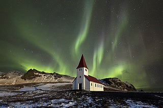
An aurora , also commonly known as the northern lights or southern lights, is a natural light display in Earth's sky, predominantly seen in high-latitude regions. Auroras display dynamic patterns of brilliant lights that appear as curtains, rays, spirals, or dynamic flickers covering the entire sky.

Space weather is a branch of space physics and aeronomy, or heliophysics, concerned with the varying conditions within the Solar System and its heliosphere. This includes the effects of the solar wind, especially on the Earth's magnetosphere, ionosphere, thermosphere, and exosphere. Though physically distinct, space weather is analogous to the terrestrial weather of Earth's atmosphere. The term "space weather" was first used in the 1950s and popularized in the 1990s. Later, it prompted research into "space climate", the large-scale and long-term patterns of space weather.

A geomagnetic storm, also known as a magnetic storm, is a temporary disturbance of the Earth's magnetosphere caused by a solar wind shock wave.

Cluster II was a space mission of the European Space Agency, with NASA participation, to study the Earth's magnetosphere over the course of nearly two solar cycles. The mission was composed of four identical spacecraft flying in a tetrahedral formation. As a replacement for the original Cluster spacecraft which were lost in a launch failure in 1996, the four Cluster II spacecraft were successfully launched in pairs in July and August 2000 onboard two Soyuz-Fregat rockets from Baikonur, Kazakhstan. In February 2011, Cluster II celebrated 10 years of successful scientific operations in space. In February 2021, Cluster II celebrated 20 years of successful scientific operations in space. As of March 2023, its mission was extended until September 2024. The China National Space Administration/ESA Double Star mission operated alongside Cluster II from 2004 to 2007.

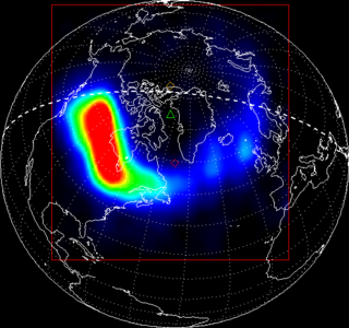
A Birkeland current is a set of electrical currents that flow along geomagnetic field lines connecting the Earth's magnetosphere to the Earth's high latitude ionosphere. In the Earth's magnetosphere, the currents are driven by the solar wind and interplanetary magnetic field and by bulk motions of plasma through the magnetosphere. The strength of the Birkeland currents changes with activity in the magnetosphere. Small scale variations in the upward current sheets accelerate magnetospheric electrons which, when they reach the upper atmosphere, create the Auroras Borealis and Australis.

The Global Geospace Science (GGS) Wind satellite is a NASA science spacecraft designed to study radio waves and plasma that occur in the solar wind and in the Earth's magnetosphere. It was launched on 1 November 1994, at 09:31:00 UTC, from launch pad LC-17B at Cape Canaveral Air Force Station (CCAFS) in Merritt Island, Florida, aboard a McDonnell Douglas Delta II 7925-10 rocket. Wind was designed and manufactured by Martin Marietta Astro Space Division in East Windsor Township, New Jersey. The satellite is a spin-stabilized cylindrical satellite with a diameter of 2.4 m and a height of 1.8 m.

Ørsted is an Earth science satellite launched in 1999 to study the Earth's geomagnetic field. It is Denmark's first satellite, named after Hans Christian Ørsted (1777–1851), a Danish physicist and professor at the University of Copenhagen, who discovered electromagnetism in 1820.

The Super Dual Auroral Radar Network (SuperDARN) is an international scientific radar network consisting of 35 high frequency (HF) radars located in both the Northern and Southern Hemispheres. SuperDARN radars are primarily used to map high-latitude plasma convection in the F region of the ionosphere, but the radars are also used to study a wider range of geospace phenomena including field aligned currents, magnetic reconnection, geomagnetic storms and substorms, magnetospheric MHD waves, mesospheric winds via meteor ionization trails, and interhemispheric plasma convection asymmetries. The SuperDARN collaboration is composed of radars operated by JHU/APL, Virginia Tech, Dartmouth College, the Geophysical Institute at the University of Alaska Fairbanks, the Institute of Space and Atmospheric Studies at the University of Saskatchewan, the University of Leicester, Lancaster University, La Trobe University, the Solar-Terrestrial Environment Laboratory at Nagoya University, the British Antarctic Survey and the Institute for Space Astrophysics and Planetology.

The plasmasphere, or inner magnetosphere, is a region of the Earth's magnetosphere consisting of low-energy (cool) plasma. It is located above the ionosphere. The outer boundary of the plasmasphere is known as the plasmapause, which is defined by an order of magnitude drop in plasma density. In 1963 American scientist Don Carpenter and Soviet astronomer Konstantin Gringauz proved the plasmasphere and plasmapause's existence from the analysis of very low frequency (VLF) whistler wave data. Traditionally, the plasmasphere has been regarded as a well behaved cold plasma with particle motion dominated entirely by the geomagnetic field and, hence, co-rotating with the Earth.

Canadian Geospace Monitoring (CGSM) is a Canadian space science program that was initiated in 2005. CGSM is funded primarily by the Canadian Space Agency, and consists of networks of imagers, meridian scanning photometers, riometers, magnetometers, digital ionosondes, and High Frequency SuperDARN radars. The overarching objective of CGSM is to provide synoptic observations of the spatio-temporal evolution of the ionospheric thermodynamics and electrodynamics at auroral and polar latitudes over a large region of Canada.

C/NOFS, or Communications/Navigation Outage Forecasting System was a USAF satellite developed by the Air Force Research Laboratory (AFRL) Space Vehicles Directorate to investigate and forecast scintillations in the Earth's ionosphere. It was launched by an Orbital Sciences Corporation Pegasus-XL launch vehicle at 17:02:48 UTC on 16 April 2008 and decayed on 28 November 2015.
Ionospheric storms are storms which contain varying densities of energised electrons in the ionosphere as produced from the Sun. Ionospheric storms are caused by geomagnetic storms. They are categorised into positive and negative storms, where positive storms have a high density of electrons and negative storms contain a lower density. The total electron content (TEC) is used to measure these densities, and is a key variable used in data to record and compare the intensities of ionospheric storms.
The impact of the solar wind onto the magnetosphere generates an electric field within the inner magnetosphere - the convection field. Its general direction is from dawn to dusk. The co-rotating thermal plasma within the inner magnetosphere drifts orthogonal to that field and to the geomagnetic field Bo. The generation process is not yet completely understood. One possibility is viscous interaction between solar wind and the boundary layer of the magnetosphere (magnetopause). Another process may be magnetic reconnection. Finally, a hydromagnetic dynamo process in the polar regions of the inner magnetosphere may be possible. Direct measurements via satellites have given a fairly good picture of the structure of that field. A number of models of that field exists.
In the height region between about 85 and 200 km altitude on Earth, the ionospheric plasma is electrically conducting. Atmospheric tidal winds due to differential solar heating or due to gravitational lunar forcing move the ionospheric plasma against the geomagnetic field lines thus generating electric fields and currents just like a dynamo coil moving against magnetic field lines. That region is therefore called ionospheric dynamo region. The magnetic manifestation of these electric currents on the ground can be observed during magnetospheric quiet conditions. They are called Sq-variations and L-variations (L=lunar) of the geomagnetic field. Additional electric currents are generated by the varying magnetospheric electric convection field. These are the DP1-currents and the polar DP2-currents. Finally, a polar-ring current has been derived from the observations which depends on the polarity of the interplanetary magnetic field. These geomagnetic variations belong to the so-called external part of the geomagnetic field. Their amplitudes reach at most about 1% of the main internal geomagnetic field Bo.

In solar physics, a solar particle event (SPE), also known as a solar energetic particle event or solar radiation storm, is a solar phenomenon which occurs when particles emitted by the Sun, mostly protons, become accelerated either in the Sun's atmosphere during a solar flare or in interplanetary space by a coronal mass ejection shock. Other nuclei such as helium and HZE ions may also be accelerated during the event. These particles can penetrate the Earth's magnetic field and cause partial ionization of the ionosphere. Energetic protons are a significant radiation hazard to spacecraft and astronauts.

The solar storms of August 1972 were a historically powerful series of solar storms with intense to extreme solar flare, solar particle event, and geomagnetic storm components in early August 1972, during solar cycle 20. The storm caused widespread electric- and communication-grid disturbances through large portions of North America as well as satellite disruptions. On 4 August 1972 the storm caused the accidental detonation of numerous U.S. naval mines near Haiphong, North Vietnam. The coronal mass ejection (CME)'s transit time from the Sun to the Earth is the fastest ever recorded.

A space hurricane is a huge, funnel-like, spiral geomagnetic storm that occurs above the polar Ionosphere of Earth, during extremely quiet conditions. They are related to the aurora borealis phenomenon, as the electron precipitation from the storm's funnel produces gigantic, cyclone-shaped auroras. Scientists believe that they occur in the polar regions of planets with magnetic fields.
